Chavanat
Chavanat | |
|---|---|
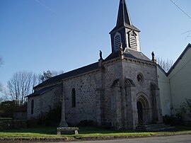 The church in Chavanat | |
show Location of Chavanat | |
 Chavanat | |
| Coordinates: 45°57′13″N 1°57′54″E / 45.9536°N 1.965°ECoordinates: 45°57′13″N 1°57′54″E / 45.9536°N 1.965°E | |
| Country | France |
| Region | Nouvelle-Aquitaine |
| Department | Creuse |
| Arrondissement | Guéret |
| Canton | Ahun |
| Intercommunality | CC Creuse Sud Ouest |
| Government | |
| • Mayor (2020–2026) | Gaël Vallaeys |
| Area 1 | 12.73 km2 (4.92 sq mi) |
| Population (Jan. 2018)[1] | 144 |
| • Density | 11/km2 (29/sq mi) |
| Time zone | UTC+01:00 (CET) |
| • Summer (DST) | UTC+02:00 (CEST) |
| INSEE/Postal code | 23060 /23250 |
| Elevation | 471–647 m (1,545–2,123 ft) (avg. 500 m or 1,600 ft) |
| 1 French Land Register data, which excludes lakes, ponds, glaciers > 1 km2 (0.386 sq mi or 247 acres) and river estuaries. | |


Chavanat (Occitan: Chavanac) is a commune in the Creuse department in the Nouvelle-Aquitaine region in central France.
Geography[]
An area of forestry and farming comprising the village and several hamlets, situated in the valley of the river Thaurion, some 8 miles (13 km) west of Aubusson at the junctions of the D3, D10 and the D941 roads.
Population[]
| Year | Pop. | ±% |
|---|---|---|
| 1962 | 140 | — |
| 1968 | 182 | +30.0% |
| 1975 | 202 | +11.0% |
| 1982 | 154 | −23.8% |
| 1990 | 144 | −6.5% |
| 1999 | 127 | −11.8% |
| 2008 | 130 | +2.4% |
Sights[]
- The church, dating from the thirteenth century.
See also[]
References[]
- ^ "Populations légales 2018". INSEE. 28 December 2020.
| Wikimedia Commons has media related to Chavanat. |
This Creuse geographical article is a stub. You can help Wikipedia by . |
Categories:
- Communes of Creuse
- Creuse geography stubs