Boussac-Bourg
Boussac-Bourg | |
|---|---|
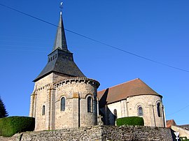 The church in Boussac-Bourg | |
show Location of Boussac-Bourg | |
 Boussac-Bourg | |
| Coordinates: 46°21′43″N 2°14′07″E / 46.3619°N 2.2353°ECoordinates: 46°21′43″N 2°14′07″E / 46.3619°N 2.2353°E | |
| Country | France |
| Region | Nouvelle-Aquitaine |
| Department | Creuse |
| Arrondissement | Aubusson |
| Canton | Boussac |
| Intercommunality | CC Creuse Confluence |
| Government | |
| • Mayor (2008–2014) | Maurice Santinon |
| Area 1 | 38.69 km2 (14.94 sq mi) |
| Population (Jan. 2018)[1] | 701 |
| • Density | 18/km2 (47/sq mi) |
| Time zone | UTC+01:00 (CET) |
| • Summer (DST) | UTC+02:00 (CEST) |
| INSEE/Postal code | 23032 /23600 |
| Elevation | 310–499 m (1,017–1,637 ft) (avg. 425 m or 1,394 ft) |
| 1 French Land Register data, which excludes lakes, ponds, glaciers > 1 km2 (0.386 sq mi or 247 acres) and river estuaries. | |


Boussac-Bourg is a commune in the Creuse department in the Nouvelle-Aquitaine region in central France.
Geography[]
A farming area comprising the village and several hamlets situated in the valley of the small river Béroux, some 23 miles (37 km) northwest of Guéret, at the junction of the D916 and the D997. The Petite Creuse river forms much of the southern border of the commune.
Population[]
| Year | Pop. | ±% |
|---|---|---|
| 1962 | 844 | — |
| 1968 | 887 | +5.1% |
| 1975 | 882 | −0.6% |
| 1982 | 892 | +1.1% |
| 1990 | 899 | +0.8% |
| 1999 | 788 | −12.3% |
| 2008 | 789 | +0.1% |
Sights[]
- The two churches, built alongside each other: Notre-Dame and St. Martin, both dating from the eleventh century.
- A rural museum, housed in an old factory.
See also[]
References[]
- ^ "Populations légales 2018". INSEE. 28 December 2020.
| Wikimedia Commons has media related to Boussac-Bourg. |
This Creuse geographical article is a stub. You can help Wikipedia by . |
Categories:
- Communes of Creuse
- Creuse geography stubs