Arlington, Nebraska
Arlington, Nebraska | |
|---|---|
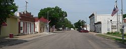 Downtown Arlington: Eagle Street | |
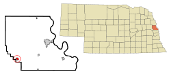 Location of Arlington, Nebraska | |
| Coordinates: 41°27′15″N 96°21′26″W / 41.45417°N 96.35722°WCoordinates: 41°27′15″N 96°21′26″W / 41.45417°N 96.35722°W | |
| Country | United States |
| State | Nebraska |
| County | Washington |
| Area | |
| • Total | 0.51 sq mi (1.32 km2) |
| • Land | 0.51 sq mi (1.32 km2) |
| • Water | 0.00 sq mi (0.00 km2) |
| Elevation | 1,188 ft (362 m) |
| Population | |
| • Total | 1,243 |
| • Estimate (2019)[3] | 1,315 |
| • Density | 2,578.43/sq mi (996.21/km2) |
| Time zone | UTC-6 (Central (CST)) |
| • Summer (DST) | UTC-5 (CDT) |
| ZIP code | 68002 |
| Area code(s) | 402 |
| FIPS code | 31-01990[4] |
| GNIS feature ID | 0827050[5] |

Arlington is a village in Washington County, Nebraska, United States. The population was 1,243 at the 2010 census. Arlington is named after Arlington, Virginia.[6]
History[]
Arlington was originally called Bell Creek (after nearby Bell Creek) and under the latter name was platted in 1869 when the Sioux City and Pacific Railroad was extended to that point.[7] Due to similarity in name with another place in Nebraska, Bell Creek was renamed Arlington, after the city of Arlington, Virginia, in 1882.[7][8][9] Arlington was home to the Marshall Nurseries, an internationally acclaimed nursery credited with inventing the fraxinus pennsylvanica tree species, one of the most common green ash trees planted in the United States of America.[10] Recent history includes the accidental damage to the north wall of the post office.[11]
Geography[]
Arlington is located at 41°27′15″N 96°21′26″W / 41.45417°N 96.35722°W (41.454244, -96.357246).[12]
According to the United States Census Bureau, the village has a total area of 0.60 square miles (1.55 km2), all land.[13]
Notable person[]
Arlington was once home to Molly Ringwald's great-great grandmother.[14]
Demographics[]
| Historical population | |||
|---|---|---|---|
| Census | Pop. | %± | |
| 1890 | 412 | — | |
| 1900 | 579 | 40.5% | |
| 1910 | 645 | 11.4% | |
| 1920 | 695 | 7.8% | |
| 1930 | 622 | −10.5% | |
| 1940 | 569 | −8.5% | |
| 1950 | 593 | 4.2% | |
| 1960 | 740 | 24.8% | |
| 1970 | 910 | 23.0% | |
| 1980 | 1,117 | 22.7% | |
| 1990 | 1,178 | 5.5% | |
| 2000 | 1,197 | 1.6% | |
| 2010 | 1,243 | 3.8% | |
| 2019 (est.) | 1,315 | [3] | 5.8% |
| U.S. Decennial Census[15] | |||
2010 census[]
As of the census[2] of 2010, there were 1,243 people, 495 households, and 344 families living in the village. The population density was 2,071.7 inhabitants per square mile (799.9/km2). There were 524 housing units at an average density of 873.3 per square mile (337.2/km2). The racial makeup of the village was 97.9% White, 0.1% African American, 0.3% Native American, 0.5% Asian, 0.7% from other races, and 0.5% from two or more races. Hispanic or Latino of any race were 2.7% of the population.
There were 495 households, of which 38.6% had children under the age of 18 living with them, 57.2% were married couples living together, 8.5% had a female householder with no husband present, 3.8% had a male householder with no wife present, and 30.5% were non-families. 27.1% of all households were made up of individuals, and 14.7% had someone living alone who was 65 years of age or older. The average household size was 2.51 and the average family size was 3.06.
The median age in the village was 38.3 years. 28.2% of residents were under the age of 18; 5.9% were between the ages of 18 and 24; 25.7% were from 25 to 44; 25.1% were from 45 to 64; and 15.2% were 65 years of age or older. The gender makeup of the village was 48.7% male and 51.3% female.
2000 census[]
As of the census[4] of 2000, there were 1,197 people, 475 households, and 342 families living in the village. The population density was 2,104.3 people per square mile (810.8/km2). There were 492 housing units at an average density of 864.9 per square mile (333.3/km2). The racial makeup of the village was 98.75% White, 0.08% Native American, 0.17% Asian, 0.08% Pacific Islander, 0.17% from other races, and 0.75% from two or more races. Hispanic or Latino of any race were 1.09% of the population.
There were 475 households, out of which 36.2% had children under the age of 18 living with them, 59.8% were married couples living together, 7.2% had a female householder with no husband present, and 27.8% were non-families. 25.9% of all households were made up of individuals, and 14.3% had someone living alone who was 65 years of age or older. The average household size was 2.52 and the average family size was 3.01.
In the village, the population was spread out, with 27.7% under the age of 18, 6.9% from 18 to 24, 28.4% from 25 to 44, 23.1% from 45 to 64, and 14.0% who were 65 years of age or older. The median age was 38 years. For every 100 females, there were 92.8 males. For every 100 females age 18 and over, there were 89.5 males.
As of 2000 the median income for a household in the village was $45,365, and the median income for a family was $51,250. Males had a median income of $35,083 versus $24,615 for females. The per capita income for the village was $19,453. About 3.3% of families and 3.7% of the population were below the poverty line, including 5.5% of those under age 18 and 3.5% of those age 65 or over.
References[]
- ^ "2019 U.S. Gazetteer Files". United States Census Bureau. Retrieved July 26, 2020.
- ^ a b "U.S. Census website". United States Census Bureau. Retrieved 2012-06-24.
- ^ a b "Population and Housing Unit Estimates". United States Census Bureau. May 24, 2020. Retrieved May 27, 2020.
- ^ a b "U.S. Census website". United States Census Bureau. Retrieved 2008-01-31.
- ^ "US Board on Geographic Names". United States Geological Survey. 2007-10-25. Retrieved 2008-01-31.
- ^ "Profile for Arlington, NE". ePodunk. Retrieved 24 August 2014.
- ^ a b "Arlington, Washington County". Center for Advanced Land Management Information Technologies. University of Nebraska. Retrieved 24 August 2014.
- ^ Fitzpatrick, Lillian L. (1960). Nebraska Place-Names. University of Nebraska Press. p. 142. ISBN 0-8032-5060-6. A 1925 edition is available for download at University of Nebraska—Lincoln Digital Commons.
- ^ Chicago and North Western Railway Company (1908). A History of the Origin of the Place Names Connected with the Chicago & North Western and Chicago, St. Paul, Minneapolis & Omaha Railways. p. 39.
- ^ Hoffman, Teresa. "Arlington students making progress in effort to recognize Marshall Nurseries, historic home". Washington County Enterprise and Pilot Tribune. Retrieved 2018-07-11.
- ^ Ruane, Chase Moffitt, Collin. "Demolition damages neighboring Arlington Post Office". Retrieved 2018-07-11.
- ^ "US Gazetteer files: 2010, 2000, and 1990". United States Census Bureau. 2011-02-12. Retrieved 2011-04-23.
- ^ "US Gazetteer files 2010". United States Census Bureau. Archived from the original on 2012-01-25. Retrieved 2012-06-24.
- ^ writer, Micah Mertes / World-Herald staff. "Molly Ringwald's Nebraska visit will air this weekend on a reality series". Omaha.com. Retrieved 2018-07-11.
- ^ "Census of Population and Housing". Census.gov. Retrieved June 4, 2015.
External links[]
Municipalities and communities of Washington County, Nebraska, United States | ||
|---|---|---|
| Cities | ||
| Villages | ||
| Townships | ||
| CDP | ||
| Other communities | ||
| Former community | ||
| ||
Metropolitan area of Omaha–Council Bluffs | ||||||
|---|---|---|---|---|---|---|
| Primary cities |
|  | ||||
| Cities over 10,000 (per 2010 Census) |
| |||||
| Cities of 5,000 to 10,000 (per 2010 Census) |
| |||||
| Cities of 1,000 to 5,000 (per 2010 Census) |
| |||||
| Census-designated places |
| |||||
| Cities and villages of fewer than 1,000 (per 2010 Census) |
| |||||
| Counties |
| |||||
- Villages in Nebraska
- Villages in Washington County, Nebraska