Bacouël
Bacouël | |
|---|---|
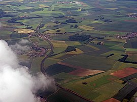 An aerial view of Bacouël and Breteuil-Embranchement railway station | |
Location of Bacouël  | |
 Bacouël | |
| Coordinates: 49°37′10″N 2°23′12″E / 49.6194°N 2.3867°ECoordinates: 49°37′10″N 2°23′12″E / 49.6194°N 2.3867°E | |
| Country | France |
| Region | Hauts-de-France |
| Department | Oise |
| Arrondissement | Clermont |
| Canton | Saint-Just-en-Chaussée |
| Intercommunality | |
| Government | |
| • Mayor (2020–2026) | Bernard Pelou |
| Area 1 | 5.48 km2 (2.12 sq mi) |
| Population (Jan. 2018)[1] | 489 |
| • Density | 89/km2 (230/sq mi) |
| Time zone | UTC+01:00 (CET) |
| • Summer (DST) | UTC+02:00 (CEST) |
| INSEE/Postal code | 60039 /60120 |
| Elevation | 81–149 m (266–489 ft) |
| 1 French Land Register data, which excludes lakes, ponds, glaciers > 1 km2 (0.386 sq mi or 247 acres) and river estuaries. | |


Bacouël (French pronunciation: [bakwɛl]) is a commune in the Oise department in northern France.
Population[]
| Year | Pop. | ±% |
|---|---|---|
| 2005 | 445 | — |
| 2006 | 454 | +2.0% |
| 2007 | 463 | +2.0% |
| 2008 | 464 | +0.2% |
| 2009 | 465 | +0.2% |
| 2010 | 466 | +0.2% |
| 2011 | 462 | −0.9% |
| 2012 | 462 | +0.0% |
| 2013 | 464 | +0.4% |
| 2014 | 466 | +0.4% |
| 2015 | 468 | +0.4% |
| 2016 | 470 | +0.4% |
See also[]
References[]
- ^ "Populations légales 2018". The National Institute of Statistics and Economic Studies. 28 December 2020.
| Wikimedia Commons has media related to Bacouël. |
| Prefecture |
|
|---|---|
| Subprefectures |
|
| Other |
|
This Oise geographical article is a stub. You can help Wikipedia by . |
Categories:
- Communes of Oise
- Oise geography stubs