Croutoy
From Wikipedia, the free encyclopedia
Commune in Hauts-de-France, France
Croutoy | |
|---|---|
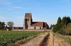 The church in Croutoy | |
 Croutoy  Croutoy | |
Coordinates:  49°23′13″N 3°02′33″E / 49.3869°N 3.0425°E / 49.3869; 3.0425Coordinates: 49°23′13″N 3°02′33″E / 49.3869°N 3.0425°E / 49.3869; 3.0425 49°23′13″N 3°02′33″E / 49.3869°N 3.0425°E / 49.3869; 3.0425Coordinates: 49°23′13″N 3°02′33″E / 49.3869°N 3.0425°E / 49.3869; 3.0425 | |
| Country | France |
| Region | Hauts-de-France |
| Department | Oise |
| Arrondissement | Compiègne |
| Canton | Compiègne-2 |
| Intercommunality | Lisières de l'Oise |
| Government | |
| • Mayor (2008–2014) | Bernard Charlet |
| Area 1 | 3.27 km2 (1.26 sq mi) |
| Population (Jan. 2018)[1] | 207 |
| • Density | 63/km2 (160/sq mi) |
| Time zone | UTC+01:00 (CET) |
| • Summer (DST) | UTC+02:00 (CEST) |
| INSEE/Postal code | 60184 /60350 |
| Elevation | 54–146 m (177–479 ft) (avg. 130 m or 430 ft) |
| 1 French Land Register data, which excludes lakes, ponds, glaciers > 1 km2 (0.386 sq mi or 247 acres) and river estuaries. | |

Croutoy is a commune in the Oise department in northern France.

L'église Notre-Dame.
See also[]
References[]
- ^ "Populations légales 2018". INSEE. 28 December 2020.
| Wikimedia Commons has media related to Croutoy. |
show
| |
|---|---|
| Prefecture |
|
| Subprefectures |
|
| Other |
|
This Oise geographical article is a stub. You can help Wikipedia by . |
- v
- t
Retrieved from ""
Categories:
- Communes of Oise
- Oise geography stubs
Hidden categories:
- Articles with short description
- Short description is different from Wikidata
- Infobox mapframe without OSM relation ID on Wikidata
- Coordinates on Wikidata
- Pages using infobox settlement with image map1 but not image map
- Commons category link from Wikidata
- Articles with BNF identifiers
- All stub articles
- Pages using the Kartographer extension