Thiers-sur-Thève
From Wikipedia, the free encyclopedia
Commune in Hauts-de-France, France
Thiers-sur-Thève | |
|---|---|
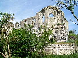 The ruined chateau chapel in Thiers-sur-Thève | |
 Coat of arms | |
 Thiers-sur-Thève  Thiers-sur-Thève | |
Coordinates:  49°09′11″N 2°34′23″E / 49.1531°N 2.5731°E / 49.1531; 2.5731Coordinates: 49°09′11″N 2°34′23″E / 49.1531°N 2.5731°E / 49.1531; 2.5731 49°09′11″N 2°34′23″E / 49.1531°N 2.5731°E / 49.1531; 2.5731Coordinates: 49°09′11″N 2°34′23″E / 49.1531°N 2.5731°E / 49.1531; 2.5731 | |
| Country | France |
| Region | Hauts-de-France |
| Department | Oise |
| Arrondissement | Senlis |
| Canton | Senlis |
| Government | |
| • Mayor (2008–2014) | Didier Jeudon |
| Area 1 | 6.25 km2 (2.41 sq mi) |
| Population (Jan. 2018)[1] | 1,070 |
| • Density | 170/km2 (440/sq mi) |
| Time zone | UTC+01:00 (CET) |
| • Summer (DST) | UTC+02:00 (CEST) |
| INSEE/Postal code | 60631 /60520 |
| Elevation | 54–102 m (177–335 ft) (avg. 63 m or 207 ft) |
| 1 French Land Register data, which excludes lakes, ponds, glaciers > 1 km2 (0.386 sq mi or 247 acres) and river estuaries. | |

Thiers-sur-Thève is a commune in the Oise department in northern France.
See also[]
References[]
- ^ "Populations légales 2018". INSEE. 28 December 2020.
| Wikimedia Commons has media related to Thiers-sur-Thève. |
show
| |
|---|---|
| Prefecture |
|
| Subprefectures |
|
| Other |
|
| show Authority control | |
|---|---|
| General |
|
| National libraries | |
This Oise geographical article is a stub. You can help Wikipedia by . |
- v
- t
Retrieved from ""
Categories:
- Communes of Oise
- Oise geography stubs
Hidden categories:
- Articles with short description
- Short description is different from Wikidata
- Infobox mapframe without OSM relation ID on Wikidata
- Coordinates on Wikidata
- Pages using infobox settlement with image map1 but not image map
- Commons category link from Wikidata
- Articles with VIAF identifiers
- Articles with BNF identifiers
- Articles with WorldCat-VIAF identifiers
- All stub articles
- Pages using the Kartographer extension