Montiers
From Wikipedia, the free encyclopedia
Commune in Hauts-de-France, France
Montiers | |
|---|---|
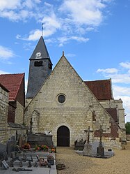 The church in Montiers | |
 Montiers  Montiers | |
Coordinates:  49°30′05″N 2°34′43″E / 49.5014°N 2.5786°E / 49.5014; 2.5786Coordinates: 49°30′05″N 2°34′43″E / 49.5014°N 2.5786°E / 49.5014; 2.5786 49°30′05″N 2°34′43″E / 49.5014°N 2.5786°E / 49.5014; 2.5786Coordinates: 49°30′05″N 2°34′43″E / 49.5014°N 2.5786°E / 49.5014; 2.5786 | |
| Country | France |
| Region | Hauts-de-France |
| Department | Oise |
| Arrondissement | Clermont |
| Canton | Estrées-Saint-Denis |
| Intercommunality | Plateau Picard |
| Government | |
| • Mayor (2020–2026) | Xavier Deneufbourg |
| Area 1 | 7.89 km2 (3.05 sq mi) |
| Population (Jan. 2018)[1] | 418 |
| • Density | 53/km2 (140/sq mi) |
| Time zone | UTC+01:00 (CET) |
| • Summer (DST) | UTC+02:00 (CEST) |
| INSEE/Postal code | 60418 /60190 |
| Elevation | 62–131 m (203–430 ft) (avg. 105 m or 344 ft) |
| 1 French Land Register data, which excludes lakes, ponds, glaciers > 1 km2 (0.386 sq mi or 247 acres) and river estuaries. | |

Montiers (French pronunciation: [mɔ̃tje]) is a communes in the Oise department in northern France.
See also[]
References[]
- ^ "Populations légales 2018". INSEE. 28 December 2020.
| Wikimedia Commons has media related to Montiers. |
show
| |
|---|---|
| Prefecture |
|
| Subprefectures |
|
| Other |
|
This Oise geographical article is a stub. You can help Wikipedia by . |
- v
- t
Retrieved from ""
Categories:
- Communes of Oise
- Oise geography stubs
Hidden categories:
- Articles with short description
- Short description is different from Wikidata
- Infobox mapframe without OSM relation ID on Wikidata
- Coordinates on Wikidata
- Pages using infobox settlement with image map1 but not image map
- Commons category link from Wikidata
- Articles with BNF identifiers
- Articles with MusicBrainz area identifiers
- All stub articles
- Pages using the Kartographer extension