Villers-Saint-Frambourg-Ognon
Villers-Saint-Frambourg-Ognon | |
|---|---|
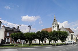 The main square in Villers-Saint-Frambourg | |
Location of Villers-Saint-Frambourg-Ognon  | |
 Villers-Saint-Frambourg-Ognon | |
| Coordinates: 49°15′21″N 2°38′24″E / 49.2558°N 2.64°ECoordinates: 49°15′21″N 2°38′24″E / 49.2558°N 2.64°E | |
| Country | France |
| Region | Hauts-de-France |
| Department | Oise |
| Arrondissement | Senlis |
| Canton | Pont-Sainte-Maxence |
| Intercommunality | Senlis Sud Oise |
| Area 1 | 14.54 km2 (5.61 sq mi) |
| Population (Jan. 2018)[1] | 712 |
| • Density | 49/km2 (130/sq mi) |
| Time zone | UTC+01:00 (CET) |
| • Summer (DST) | UTC+02:00 (CEST) |
| INSEE/Postal code | 60682 /60810 |
| Elevation | 63–215 m (207–705 ft) |
| 1 French Land Register data, which excludes lakes, ponds, glaciers > 1 km2 (0.386 sq mi or 247 acres) and river estuaries. | |


Villers-Saint-Frambourg-Ognon is a commune in the Oise department in northern France. It was established on 1 January 2019 by merger of the former communes of Villers-Saint-Frambourg (the seat) and Ognon.[2]
See also[]
References[]
- ^ "Populations légales 2018". The National Institute of Statistics and Economic Studies. 28 December 2020.
- ^ Arrêté préfectoral 28 September 2018, modified 14 December 2018 (in French)
| Wikimedia Commons has media related to Villers-Saint-Frambourg-Ognon. |
| Prefecture |
|
|---|---|
| Subprefectures |
|
| Other |
|
This Oise geographical article is a stub. You can help Wikipedia by . |
Categories:
- Communes of Oise
- Populated places established in 2019
- 2019 establishments in France
- Oise geography stubs