Barili
Barili | |
|---|---|
| Municipality of Barili | |
 Poblacion | |
 Flag | |
 Map of Cebu with Barili highlighted | |
show OpenStreetMap | |
 Barili Location within the Philippines | |
| Coordinates: 10°07′N 123°32′E / 10.12°N 123.53°ECoordinates: 10°07′N 123°32′E / 10.12°N 123.53°E | |
| Country | Philippines |
| Region | Central Visayas |
| Province | Cebu |
| District | 3rd district |
| Founded | 1632 |
| Barangays | 42 (see Barangays) |
| Government | |
| • Type | Sangguniang Bayan |
| • Mayor | Julieto N. Flores |
| • Vice Mayor | Luisito L. Ponsica |
| • Representative | Pablo John F. Garcia |
| • Municipal Council | show
Members |
| • Electorate | 49,761 voters (2019) |
| Area | |
| • Total | 122.21 km2 (47.19 sq mi) |
| Elevation | 92 m (302 ft) |
| Highest elevation | 548 m (1,798 ft) |
| Lowest elevation | 0 m (0 ft) |
| Population (2020 census) [3] | |
| • Total | 80,715 |
| • Density | 660/km2 (1,700/sq mi) |
| • Households | 15,679 |
| Economy | |
| • Income class | 2nd municipal income class |
| • Poverty incidence | 30.43% (2015)[4] |
| • Revenue | ₱145,272,827.87 (2016) |
| Service provider | |
| • Electricity | Cebu 1 Electric Cooperative (CEBECO 1) |
| Time zone | UTC+8 (PST) |
| ZIP code | 6036 |
| PSGC | |
| IDD : area code | +63 (0)32 |
| Climate type | tropical rainforest climate |
| Native languages | Cebuano Tagalog |


Barili, officially the Municipality of Barili (Cebuano: Lungsod sa Barili; Tagalog: Bayan ng Barili), is a 2nd class municipality in the province of Cebu, Philippines. According to the 2020 census, it has a population of 80,715 people. [3]
History[]
The word barili comes from the name of a local grass called balili. The municipality was founded in 1632, though the parish of Barili was established in 1614. A cross was erected by conquistadores on their arrival at 1602, and still exists today.
It was in Barili that the Japanese forces captured Chief Justice José Abad Santos while on his way to Toledo as his escape route to Negros.
In 2006, the town became the first municipality in Cebu province to give protections to its heritage sites through Municipal Ordinance No. 04-06-01, s. 2006, declaring certain shrines, houses, buildings, monuments, markers and other areas as cultural properties of the municipality.
Geography[]
Barili is bordered to the north by the town of Aloguinsan, to the west is the Tañon Strait, to the east is the city of Carcar and the town of Sibonga, and to the south is the town of Dumanjug.
Barangays[]
Barili comprises 42 barangays:
| PSGC | Barangay | Population | ±% p.a. | |||
|---|---|---|---|---|---|---|
| 2020 [3] | 2010 [5] | |||||
| 072210001 | Azucena | 2.6% | 2,061 | 1,647 | 2.19% | |
| 072210002 | Bagakay | 1.1% | 904 | 824 | 0.90% | |
| 072210003 | Balao | 3.0% | 2,446 | 1,776 | 3.14% | |
| 072210004 | Bolocboloc | 2.8% | 2,226 | 1,932 | 1.38% | |
| 072210005 | Budbud | 2.0% | 1,628 | 1,513 | 0.71% | |
| 072210006 | Bugtong Kawayan | 1.0% | 800 | 719 | 1.04% | |
| 072210007 | Cabcaban | 2.4% | 1,922 | 1,543 | 2.14% | |
| 072210016 | Cagay | 2.2% | 1,813 | 1,568 | 1.41% | |
| 072210008 | Campangga | 1.8% | 1,455 | 1,481 | −0.17% | |
| 072210020 | Candugay | 2.2% | 1,777 | 1,443 | 2.03% | |
| 072210009 | Dakit | 2.3% | 1,864 | 1,672 | 1.05% | |
| 072210010 | Giloctog | 2.0% | 1,589 | 1,502 | 0.54% | |
| 072210012 | Giwanon | 2.3% | 1,830 | 1,608 | 1.26% | |
| 072210011 | Guibuangan | 2.9% | 2,303 | 2,212 | 0.39% | |
| 072210013 | Gunting | 3.5% | 2,861 | 2,566 | 1.06% | |
| 072210014 | Hilasgasan | 0.9% | 747 | 863 | −1.38% | |
| 072210015 | Japitan | 4.7% | 3,821 | 3,527 | 0.78% | |
| 072210017 | Kalubihan | 1.7% | 1,403 | 1,197 | 1.54% | |
| 072210018 | Kangdampas | 1.3% | 1,077 | 955 | 1.17% | |
| 072210021 | Luhod | 1.2% | 955 | 917 | 0.39% | |
| 072210022 | Lupo | 0.8% | 673 | 614 | 0.89% | |
| 072210023 | Luyo | 1.4% | 1,091 | 1,071 | 0.18% | |
| 072210024 | Maghanoy | 1.6% | 1,265 | 1,077 | 1.56% | |
| 072210025 | Maigang | 2.5% | 1,978 | 1,688 | 1.54% | |
| 072210026 | Malolos | 2.2% | 1,742 | 1,617 | 0.72% | |
| 072210027 | Mantalongon | 3.7% | 2,988 | 2,566 | 1.48% | |
| 072210028 | Mantayupan | 2.9% | 2,317 | 2,092 | 0.99% | |
| 072210029 | Mayana | 1.5% | 1,250 | 1,075 | 1.47% | |
| 072210030 | Minolos | 3.0% | 2,399 | 2,311 | 0.36% | |
| 072210031 | Nabunturan | 1.0% | 774 | 684 | 1.20% | |
| 072210032 | Nasipit | 1.5% | 1,172 | 1,030 | 1.25% | |
| 072210034 | Pancil | 1.4% | 1,153 | 890 | 2.53% | |
| 072210035 | Pangpang | 1.2% | 995 | 853 | 1.50% | |
| 072210036 | Paril | 1.5% | 1,241 | 1,137 | 0.85% | |
| 072210037 | Patupat | 2.3% | 1,850 | 1,663 | 1.03% | |
| 072210038 | Poblacion | 6.4% | 5,141 | 4,808 | 0.65% | |
| 072210039 | San Rafael | 2.0% | 1,654 | 1,157 | 3.51% | |
| 072210040 | Santa Ana | 2.6% | 2,087 | 2,045 | 0.20% | |
| 072210041 | Sayaw | 1.6% | 1,298 | 1,090 | 1.70% | |
| 072210042 | Tal‑ot | 2.3% | 1,876 | 1,639 | 1.31% | |
| 072210043 | Tubod | 2.7% | 2,176 | 1,889 | 1.37% | |
| 072210044 | Vito | 1.6% | 1,260 | 1,063 | 1.65% | |
| Total | 80,715 | 65,524 | 2.03% | |||
Climate[]
| hideClimate data for Barili, Cebu | |||||||||||||
|---|---|---|---|---|---|---|---|---|---|---|---|---|---|
| Month | Jan | Feb | Mar | Apr | May | Jun | Jul | Aug | Sep | Oct | Nov | Dec | Year |
| Average high °C (°F) | 29 (84) |
30 (86) |
31 (88) |
32 (90) |
31 (88) |
30 (86) |
30 (86) |
30 (86) |
30 (86) |
29 (84) |
29 (84) |
29 (84) |
30 (86) |
| Average low °C (°F) | 22 (72) |
22 (72) |
23 (73) |
24 (75) |
25 (77) |
25 (77) |
24 (75) |
24 (75) |
24 (75) |
24 (75) |
24 (75) |
23 (73) |
24 (75) |
| Average precipitation mm (inches) | 42 (1.7) |
34 (1.3) |
40 (1.6) |
61 (2.4) |
124 (4.9) |
188 (7.4) |
190 (7.5) |
191 (7.5) |
189 (7.4) |
186 (7.3) |
124 (4.9) |
73 (2.9) |
1,442 (56.8) |
| Average rainy days | 10.0 | 8.5 | 9.5 | 12.8 | 22.3 | 26.8 | 28.4 | 27.9 | 27.3 | 27.6 | 20.5 | 13.1 | 234.7 |
| Source: Meteoblue (Use with caution: this is modeled/calculated data, not measured locally.)[6] | |||||||||||||
Demographics[]
| Year | Pop. | ±% p.a. |
|---|---|---|
| 1903 | 31,617 | — |
| 1918 | 33,481 | +0.38% |
| 1939 | 29,247 | −0.64% |
| 1948 | 27,267 | −0.78% |
| 1960 | 28,656 | +0.41% |
| 1970 | 34,714 | +1.93% |
| 1975 | 36,286 | +0.89% |
| 1980 | 39,560 | +1.74% |
| 1990 | 47,789 | +1.91% |
| 1995 | 52,060 | +1.62% |
| 2000 | 57,764 | +2.25% |
| 2007 | 60,430 | +0.62% |
| 2010 | 65,524 | +2.99% |
| 2015 | 73,862 | +2.31% |
| 2020 | 80,715 | +1.76% |
| Source: Philippine Statistics Authority [7] [5] [8][9] | ||
Economy[]
| Poverty Incidence of Barili | |
| Source: Philippine Statistics Authority[10][11][12][13][14][15] | |
Barili is an agricultural town, and its economic output is more on food security. Farming and animal husbandry are the main livelihood of people residing in the town. They focus on rice and corn farming, animal husbandry such as hog, cattle and poultry, fruit farming and even vegetable gardening. Barili has its established Mantalongon Livestock Market[16] where you can buy live animals which collectively come from Southern parts of Cebu and even from Negros Province. Barili is also known for its Japitan Fish Port.[17] located in Barangay Japitan, 4–5 km away from its public market. Barangay Guiwanon of the same town is known for production of hand-weaved 'native hats made from leaves of the buri tree and other weaved native products.[18]
Tourism[]
Mantayupan Falls are located close to the eastern end of the Carcar—Barili Road where it connects to the national highway.[19] The falls are approximately 61 metres (200 ft) high but do not have a direct descent. Pools at various heights flow into the basin. The waterfall is one of three main tourist attractions in the interior barangays of Barili.[20]
Gallery[]
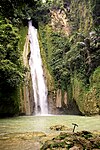
Mantayupan Falls
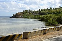
Tañon Strait coast at Barili

Historic houses in Barili


See also[]
References[]
- ^ Municipality of Barili | (DILG)
- ^ "2015 Census of Population, Report No. 3 – Population, Land Area, and Population Density" (PDF). Philippine Statistics Authority. Quezon City, Philippines. August 2016. ISSN 0117-1453. Archived (PDF) from the original on May 25, 2021. Retrieved July 16, 2021.
- ^ Jump up to: a b c Census of Population (2020). "Region VII (Central Visayas)". Total Population by Province, City, Municipality and Barangay. PSA. Retrieved 8 July 2021.
- ^ https://psa.gov.ph/sites/default/files/City%20and%20Municipal-level%20Small%20Area%20Poverty%20Estimates_%202009%2C%202012%20and%202015_0.xlsx; publication date: 10 July 2019; publisher: Philippine Statistics Authority.
- ^ Jump up to: a b Census of Population and Housing (2010). "Region VII (Central Visayas)". Total Population by Province, City, Municipality and Barangay. NSO. Retrieved 29 June 2016.
- ^ "Barili: Average Temperatures and Rainfall". Meteoblue. Retrieved 10 May 2020.
- ^ Census of Population (2015). "Region VII (Central Visayas)". Total Population by Province, City, Municipality and Barangay. PSA. Retrieved 20 June 2016.
- ^ Censuses of Population (1903–2007). "Region VII (Central Visayas)". Table 1. Population Enumerated in Various Censuses by Province/Highly Urbanized City: 1903 to 2007. NSO.
- ^ "Province of Cebu". Municipality Population Data. Local Water Utilities Administration Research Division. Retrieved 17 December 2016.
- ^ "Poverty incidence (PI):". Philippine Statistics Authority. Retrieved 28 December 2020.
- ^ https://psa.gov.ph/sites/default/files/NSCB_LocalPovertyPhilippines_0.pdf; publication date: 29 November 2005; publisher: Philippine Statistics Authority.
- ^ https://psa.gov.ph/sites/default/files/2003%20SAE%20of%20poverty%20%28Full%20Report%29_1.pdf; publication date: 23 March 2009; publisher: Philippine Statistics Authority.
- ^ https://psa.gov.ph/sites/default/files/2006%20and%202009%20City%20and%20Municipal%20Level%20Poverty%20Estimates_0_1.pdf; publication date: 3 August 2012; publisher: Philippine Statistics Authority.
- ^ https://psa.gov.ph/sites/default/files/2012%20Municipal%20and%20City%20Level%20Poverty%20Estima7tes%20Publication%20%281%29.pdf; publication date: 31 May 2016; publisher: Philippine Statistics Authority.
- ^ https://psa.gov.ph/sites/default/files/City%20and%20Municipal-level%20Small%20Area%20Poverty%20Estimates_%202009%2C%202012%20and%202015_0.xlsx; publication date: 10 July 2019; publisher: Philippine Statistics Authority.
- ^ "Ground Breaking Ceremony of the Mantalongon Livestock Market | Facebook". www.facebook.com. Retrieved 2019-03-01.
- ^ "fish port japitan barili cebu - Google Search". www.google.com. Retrieved 2019-03-01.
- ^ "Mother continues business for workers". Philippine Daily Inquirer. Retrieved 2019-03-01.
- ^ 10°6′24″N 123°31′16″E / 10.10667°N 123.52111°E
- ^ Cabigas 2011.
Sources[]
- Cabigas, Estan (29 September 2011), "Visiting Mantayupan Falls after 23 years" (Photographic essay), Langyaw, archived from the original on 1 October 2011, retrieved 12 February 2015
- Pace, Azucena (2009). Barili The Town The People The Years, A History. Cebu: Local Government Unit of Barili, Cebu. ISBN 978-9719441601.
External links[]
![]() Media related to Barili at Wikimedia Commons
Media related to Barili at Wikimedia Commons
| show Places adjacent to Barili |
|---|
| Authority control |
|
|---|
- Municipalities of Cebu
- Waterfalls of the Philippines
- Landforms of Cebu
- Tourist attractions in Cebu