Blaru
Blaru | |
|---|---|
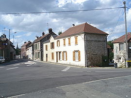 A view within Blaru | |
show Location of Blaru | |
 Blaru | |
| Coordinates: 49°02′56″N 1°28′44″E / 49.049°N 1.479°ECoordinates: 49°02′56″N 1°28′44″E / 49.049°N 1.479°E | |
| Country | France |
| Region | Île-de-France |
| Department | Yvelines |
| Arrondissement | Mantes-la-Jolie |
| Canton | Bonnières-sur-Seine |
| Intercommunality | Portes de l'Île-de-France |
| Government | |
| • Mayor (2020–2026) | Joëlle Rollin[1] |
| Area 1 | 14.84 km2 (5.73 sq mi) |
| Population (Jan. 2018)[2] | 893 |
| • Density | 60/km2 (160/sq mi) |
| Time zone | UTC+01:00 (CET) |
| • Summer (DST) | UTC+02:00 (CEST) |
| INSEE/Postal code | 78068 /78270 |
| Elevation | 50–152 m (164–499 ft) (avg. 90 m or 300 ft) |
| 1 French Land Register data, which excludes lakes, ponds, glaciers > 1 km2 (0.386 sq mi or 247 acres) and river estuaries. | |


Saint-Hilaire

Priory of Béthanie
Blaru is a commune in the Yvelines department in north-central France.
See also[]
- Communes of the Yvelines department
References[]
- ^ "Répertoire national des élus: les maires". data.gouv.fr, Plateforme ouverte des données publiques françaises (in French). 2 December 2020. Retrieved 7 December 2020.
- ^ "Populations légales 2018". INSEE. 28 December 2020.
| Wikimedia Commons has media related to Blaru. |
| show Communes of the Yvelines department |
|---|
This Yvelines geographical article is a stub. You can help Wikipedia by . |
Categories:
- Communes of Yvelines
- Yvelines geography stubs