Hardricourt
Hardricourt | |
|---|---|
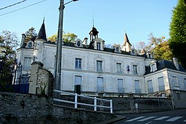 Town hall | |
 Coat of arms | |
show Location of Hardricourt | |
 Hardricourt | |
| Coordinates: 49°00′32″N 1°53′40″E / 49.0089°N 1.8944°ECoordinates: 49°00′32″N 1°53′40″E / 49.0089°N 1.8944°E | |
| Country | France |
| Region | Île-de-France |
| Department | Yvelines |
| Arrondissement | Mantes-la-Jolie |
| Canton | Les Mureaux |
| Intercommunality | CU Grand Paris Seine et Oise |
| Government | |
| • Mayor (2020–2026) | Yann Scotte[1] |
| Area 1 | 3.28 km2 (1.27 sq mi) |
| Population (Jan. 2018)[2] | 2,392 |
| • Density | 730/km2 (1,900/sq mi) |
| Time zone | UTC+01:00 (CET) |
| • Summer (DST) | UTC+02:00 (CEST) |
| INSEE/Postal code | 78299 /78250 |
| Elevation | 18–118 m (59–387 ft) (avg. 58 m or 190 ft) |
| 1 French Land Register data, which excludes lakes, ponds, glaciers > 1 km2 (0.386 sq mi or 247 acres) and river estuaries. | |


Hardricourt (French pronunciation: [aʁdʁikuʁ]) is a commune in the Yvelines department in the Île-de-France region in north-central France.
The castle of Hardricourt was between 1970 and 2011 the property of Jean-Bedel Bokassa, from 1966 dictator and between 1977 and 1979 self-appointed emperor of the Central African Republic. He was overthrown in 1977 and, after a period in the Ivory Coast, lived in the castle in exile from c. 1983 to 1986.[3]
See also[]
- Communes of the Yvelines department
References[]
- ^ "Répertoire national des élus: les maires". data.gouv.fr, Plateforme ouverte des données publiques françaises (in French). 2 December 2020. Retrieved 7 December 2020.
- ^ "Populations légales 2018". INSEE. 28 December 2020.
- ^ Le Château d'Hardricourt
| Wikimedia Commons has media related to Hardricourt. |
| show Communes of the Yvelines department |
|---|
| show Authority control |
|---|
This Yvelines geographical article is a stub. You can help Wikipedia by . |
Categories:
- Communes of Yvelines
- Yvelines geography stubs