Border irregularities of the United States
This article needs additional citations for verification. (December 2006) |
Border irregularities of the United States, particularly panhandles and highway incursions into other jurisdictions, are shown here. Often they are a result of borders which do not conform to geological features.
International[]
Canada[]
There are several exclaves between the United States and Canada, including the entire state of Alaska (though the state can still be accessed by sea from the United States, except the small settlement of Hyder which is only accessible by road from British Columbia). Other exclaves include Akwesasne, the Northwest Angle, and Point Roberts.
The status of the waters around Nunez Rocks is disputed. Nunez Rocks is a low-tide elevation ("bare at half-tide"[1]) area (LTE) that is south of a line known as the "A-B" Line,[2] which was defined in a 1903 arbitration decision on the Alaska–Canada boundary.[3] The court specified the initial boundary point (Point "A") at the northern end of Dixon Entrance[4] and Point "B" 72 nautical miles (83 mi; 133 km) to the east.[5] Canada relies on the "A-B" Line as rendering nearly all of Dixon Entrance as Canadian internal waters. The U.S. does not recognize the "A-B" Line as an official boundary, instead regarding it as allocating sovereignty over the land masses within the Dixon Entrance,[2] with Canada's land south of the line. The U.S. regards the waters as subject to international marine law, and in 1977 it defined an equidistant territorial sea throughout Dixon Entrance.[2] This territory, which surrounds Nunez Rocks, extends south of the "A-B" line for the most part.[2] The United States has not ratified the Law of the Sea Treaty, although it adheres to most of its principles as customary international law. Under the treaty, LTEs may be used as basepoints for a territorial sea, and the U.S. uses Nunez Rocks as a basepoint. As a non-signatory, however, there is nothing preventing the U.S. from claiming areas beyond the scope of the Law of the Sea Treaty. The fact remains that, for about half of each day, above-water territory that Canada regards as Canadian is surrounded by sea territory that the U.S. has declared to be American.
Another disputed area is the Grey Zone, including Machias Seal Island, in the Gulf of Maine.
The Aroostook Valley Country Club is a golf course which straddles the Canada–US border, between the U.S. state of Maine and the Canadian province of New Brunswick. The club, located near Perth-Andover, New Brunswick and Fort Fairfield, Maine, has its course (except part of the tee area for the ninth hole, and possibly part of a sand trap on the first hole) and clubhouse on the Canadian side of the border and its parking lot and pro shop on the American side.[6]
East Richford Slide Road in the U.S. state of Vermont crosses into the Canadian province of Québec for a distance of approximately 330 feet (100 m) before returning to the United States.[7]
The Piney Pinecreek Border Airport runway straddles the Canada–U.S. border, between the U.S. state of Minnesota and the Canadian province of Manitoba.[8] When flying to this airport, travelers must inform customs officials at least one hour prior to landing.[citation needed]
Mexico[]
In Texas and Mexico, shifts in the course of the lower Rio Grande have created numerous bancos. Under the Boundary Treaty of 1970 and earlier treaties, the United States and Mexico have maintained the actual course of the river as the international boundary, but both must approve proposed changes. From 1989 to 2009, there were 128 locations where the river changed course, causing land that had been on one side of the river to then occupy the opposite bank. Until the boundary is officially changed, there are 60 small exclaves of the state of Texas now lying on the southern side of the river, as well as 68 such exclaves of Mexico on the northern side of the river.
Russia[]
The legal status of the U.S.-Russian border is unclear. The United States Senate ratified a treaty setting the boundary with the Soviet Union in 1991. However, shortly after, the Soviet Union collapsed, and the Russian parliament never voted on the treaty.
States and territories[]
Separated by water[]
- Rosecrans Memorial Airport, though lying within the city limits of St. Joseph, Missouri, is inaccessible by land from Missouri due to a change in the course of the Missouri River following the Great Flood of 1951. It is accessible only by crossing the river, then turning north through Elwood, Kansas.
- Delaware has two exclaves of land on the New Jersey side of the Delaware Bay northwest of Fort Mott State Park and Killcohook National Wildlife Refuge: Finns Point and Artificial Island, Delaware near the Salem Nuclear Power Plant in Salem County, New Jersey. At that point, the border runs along New Jersey's mean low-tide mark. Thus when the spoils from the navigational dredging of the bay were dumped alongside Fort Mott and the Salem plant excavations nearby, both sites became part of New Castle County, Delaware.
- Iowa's city of Carter Lake on the Nebraska side of the Missouri River, since 1877 when a flood redirected the Missouri river and formed an oxbow lake and a section of Iowa trapped on the other side of the river.
- Several small areas of western Kentucky lie north of the Ohio River on what is otherwise the Indiana side, including one area south of Evansville, Indiana that accommodates a horse racing track.
- Several portions of Nebraska lie east of the Missouri River, mainly due to flooding and changes in the river's path:
- DeSoto National Wildlife Refuge near Blair, which borders Iowa. A portion of Iowa is also on the Nebraska side in the same area.
- McKissick Island near Peru, which borders Missouri.
- A section of land that borders Iowa, Sloan.
- Onawa Materials Yard Wildlife Area and Middle Decatur Bend State Wildlife Management Area near Onawa, Iowa.
- The mainland portion of Newport County, Rhode Island is separated from the rest of the state by the delta of the Taunton River. The only land connection is through Massachusetts, but it is possible to access these communities by bridge without leaving Rhode Island.
- The Eastern Shore of Virginia is separated by the Chesapeake Bay from the rest of the state.
- Divided coastal islands:
- Rhode Island and Connecticut share Sandy Point Island in Little Narragansett Bay.
- New Jersey and New York share Shooter's Island, a bird sanctuary located in the south end of Newark Bay off the north shore of Staten Island. (The small portion in New Jersey is further divided between two counties.)
- Delaware and Maryland share Fenwick Island.
- Maryland and Virginia share Smith Island in the Chesapeake Bay, as well as Assateague Island on the Atlantic coast.
- Virginia and North Carolina share Knotts Island, and , separated from the Atlantic by an intracoastal waterway.
- North Carolina and South Carolina share Bird Island on the Atlantic coast.
- Florida and Alabama share Perdido Key in the Gulf of Mexico.
- Alabama and Mississippi share in the Gulf of Mexico.
- Alabama and Mississippi share an island between and on the Gulf Coast.
- Minnesota and Wisconsin share State Wildlife Management Area in Saint Louis Bay between Duluth, Minnesota, and Superior, Wisconsin.
- Michigan and Ohio share Turtle Island in Lake Erie.
- At the mouth of the Columbia River, Oregon and Washington share Sand Island Dike and .[9]
Separated by the Mississippi River[]
These border irregularities were caused by changes in the Mississippi River during the 1812 New Madrid earthquake or other river changes:
- Over a period of about 24 hours on 7 March 1876, the Mississippi River abandoned its former channel that defined the Tennessee-Arkansas border, and established a new channel east of Tennessee's Reverie and Corona, located in Tipton County north-northwest of Memphis.[10]
Other irregularities involving the Mississippi River:
- Arkansas has territory at 35°39′N 89°52′W / 35.65°N 89.87°W across the Mississippi River on the northwest edge of Tennessee's Fort Pillow State Park, north of the Corona/Reverie, Tennessee irregularity (mentioned in the previous section).
- Illinois's Kaskaskia, Missouri's Grand Tower Island and other Illinois and Missouri territory on each other's side of the Mississippi River.
- The Kentucky Bend between Missouri and Tennessee.
- The state of Mississippi controls at least 11 exclaves on the west bank of the Mississippi River in Louisiana, while Louisiana owns 8 exclaves on Mississippi's side.
- Louisiana and Mississippi also share 3 islands, at 31.754078 degrees north, 91.376270 west; 31.885015 north, 91.228315 west; as well as Middle Ground Island, Togo Island, Davis Island at 32°08′N 91°03′W / 32.13°N 91.05°W, an island at 32°22′16″N 90°53′20″W / 32.371°N 90.889°W, Stack Island at 32°49′26″N 91°08′10″W / 32.824°N 91.136°W, Cottonwood Island at 32°39′04″N 91°09′25″W / 32.651°N 91.157°W, and an island at 32°40′26″N 91°08′49″W / 32.674°N 91.147°W.
- Mississippi, Louisiana, and Arkansas share an island at their tri-point at 33°00′22″N 91°10′08″W / 33.006°N 91.169°W.
- Mississippi also owns 14 exclaves on the bank in Arkansas, while Arkansas has 15 of its own on Mississippi's side.
- Arkansas and Mississippi share islands at 34°53′42″N 90°16′05″W / 34.895°N 90.268°W, 34°13′44″N 90°50′49″W / 34.229°N 90.847°W, 34°49′44″N 90°25′52″W / 34.829°N 90.431°W, 34°10′37″N 90°53′06″W / 34.177°N 90.885°W, 33°43′55″N 91°08′31″W / 33.732°N 91.142°W, 33°08′31″N 91°05′31″W / 33.142°N 91.092°W, 33°07′44″N 91°08′10″W / 33.129°N 91.136°W, 33°14′06″N 91°05′53″W / 33.235°N 91.098°W, 33°21′29″N 91°07′05″W / 33.358°N 91.118°W, 33°23′35″N 91°06′22″W / 33.393°N 91.106°W, 33°24′29″N 91°07′26″W / 33.408°N 91.124°W, 33°29′53″N 91°10′34″W / 33.498°N 91.176°W, 33°34′08″N 91°10′16″W / 33.569°N 91.171°W, 33°45′25″N 91°07′01″W / 33.757°N 91.117°W, 34°14′49″N 90°55′19″W / 34.247°N 90.922°W, 34°17′49″N 90°44′35″W / 34.297°N 90.743°W, 34°40′44″N 90°33′58″W / 34.679°N 90.566°W, 34°50′49″N 90°23′17″W / 34.847°N 90.388°W, 34°53′17″N 90°17′02″W / 34.888°N 90.284°W, 35°01′30″N 90°15′07″W / 35.025°N 90.252°W, 35°02′20″N 90°12′29″W / 35.039°N 90.208°W and 33°22′55″N 91°06′58″W / 33.382°N 91.116°W.
- There are also many irregularities along the river between Arkansas/Tennessee, Missouri/Tennessee, and Missouri/Kentucky.

Other irregularities[]
- The District of Columbia is surrounded by the states of Virginia (on its southwest side) and Maryland (on its southeast, northeast, and northwest sides); it interrupts those states' common border, which is the south shore of the Potomac River both upstream and downstream from the District. The portion of the Potomac River that passes Washington is virtually entirely within the District's border, as the District extends to the south bank.
- Marble Hill remains legally part of the borough of Manhattan, even though it was separated from the island of Manhattan by construction of the Harlem Ship Canal in 1895 and then connected to the mainland and the Bronx in 1914.
- The Delaware Wedge adjacent to Maryland and Pennsylvania[11]
- The Erie Triangle.
- Michigan's Lost Peninsula Marina and neighboring Erie Township north of Toledo and Washington Township, Lucas County, Ohio; resulting from Toledo War border realignment.
- Massachusetts's Southwick Jog.
- Missouri's Bootheel.
- The above-water portion of Liberty Island is part of New York State, but being located in New York Bay, is entirely surrounded by the waters of New Jersey. Ellis Island is also in the waters of New Jersey, but the naturally formed part of the island belongs to New York, while the artificial infill portion surrounding it belongs to New Jersey. The original land area of Ellis Island is a true exclave of New York State.
- Cupsogue Beach County Park on Long Island in New York is part of the town of Brookhaven but can only be accessed by road by going through Westhampton Beach in the town of Southampton due to the barrier island being cut in a Nor'easter in 1931, creating Moriches Inlet.
- Kure Atoll in Hawaii is an exclave of Hawaii — it is separated from the rest of Hawaii because of Midway Atoll (Midway Atoll is politically part of the U.S. Minor Outlying Islands, not the state of Hawaii).[12]
- Swains Island in American Samoa is very far from the rest of American Samoa — it is geographically and culturally part of the Tokelau island chain.[13][14] The territory of Tokelau claims Swains Island as part of its territory.[15]
- Parts of Delaware exist within NJ - Delaware and New Jersey are largely divided by the Delaware River and Delaware Bay. However, the two states also share two land borders. For example, in Pennsville NJ, a section of land that is mainly marsh area, (approximately 1.7 miles (2.7 km) in length and 0.6 miles (0.97 km) wide) is actually owned by Delaware.[16]
Highway system irregularities[]
- Oklahoma State Highway 20 forms a concurrency with Arkansas Highway 43 between Maysville, Arkansas and the Missouri state line, where AR-43 becomes Missouri Highway 43.
- Interstate 24 briefly enters Georgia for a few miles but comes back into Tennessee, and retains Tennessee exit numbers, but not Tennessee mile markers.
- Minnesota State Highway 23 enters Wisconsin near Duluth for one-half mile (0.80 km).
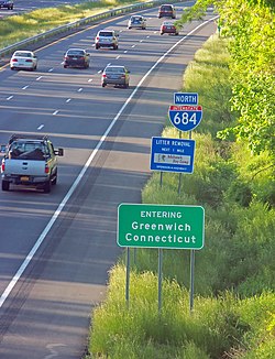
- Interstate 684, otherwise in New York, takes a shortcut across the northwest corner of the Connecticut Panhandle without any exits or signage save a standard Connecticut sign welcoming travelers to Greenwich.
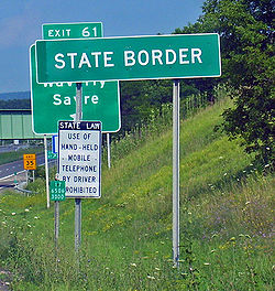
- Interstate 86, formerly NY 17, drops just south of the Pennsylvania state line for approximately one mile (1.6 km) between Waverly and Sayre. The crossing is indicated by signs in both directions, but the New York signage and exit numbering remain (prior to being converted to an interstate, Route 17's sequential exit numbering began at its Pennsylvania terminus and continued into New York, one of the few highways in the U.S. where this was so; however, it is not uncommon for state highways to retain their route numbers when they change state highway shields at the border).
- New York State Route 120A runs along the Connecticut state line for much of its length, apart from 3.6 miles (5.8 km) that enter the state, yet retains its New York signage and is still maintained by the New York State Department of Transportation.
- Montana State Highway 43 runs for approximately one mile (1.6 km) inside Idaho, between Chief Joseph Pass and Lost Trail Pass. It crosses into Montana again just yards from its junction with US 93.
- The Woodrow Wilson Bridge carries I-95 and I-495 (the Capital Beltway) across the Potomac River south of the District of Columbia. It connects Maryland on the east shore of the river with Virginia on the west shore. However, a few hundred feet of roadway close to the Virginia side crosses the southernmost point of the District of Columbia and thus is in neither Maryland nor Virginia.
- 13 miles (21 km) of Pennsylvania Route 426 goes through New York, though unlike other state highways on the list that briefly enter other states with their normal symbols, this one is badged as New York State Route 426 between both borders of Pennsylvania.
- Highways US-2 and US-141 run in the state of Wisconsin and Michigan twice nonconsecutively.
- New Jersey Route 440 enters New York at Outerbridge Crossing, becomes New York State Route 440 for 13 miles (21 km), and then re-enters New Jersey at Bayonne Bridge and becomes again New Jersey Route 440.
- Near Williamson, West Virginia, U.S. Route 52 crosses the West Virginia/Kentucky border (the Tug Fork River) 4 times, entering Pike County, Kentucky twice, and both times re-entering Mingo County, West Virginia within 1 mile (1.6 km).
- U.S. Route 62 starts at the Mexican border in El Paso, Texas, enters New Mexico near Carlsbad Caverns National Park, travels through New Mexico for 110 miles (180 km), and then re-enters Texas near Hobbs, New Mexico. (Also, U.S. Route 62 is the only east–west (even-numbered) U.S. highway that travels from Mexico to Canada, ending in Niagara Falls, New York within 1 mile (1.6 km) of the Canadian border.)
- U.S. Route 72 starts in Tennessee (in Memphis), travels through Mississippi for 90 miles (140 km), travels through Alabama for 167 miles (269 km), and then re-enters Tennessee (and ends in Chattanooga).
- Highway US 395 crosses from California into Nevada at Topaz Lake and 85 miles (137 km) later re-enters California.
- U.S. Route 95 starts in the Mountain Time Zone at the Mexican border in Arizona. It crosses the Colorado River into the Pacific Time Zone and California. In Oregon it re-enters the Mountain Time Zone. In Idaho it crosses the Pacific/Mountain time zone boundary (the Salmon River) 3 more times in Idaho County, ending at the Canadian border in the Pacific Time Zone.
- U.S. Route 41 starts in the Eastern Time Zone in Miami, Florida. It crosses into the Central Time Zone near Chattanooga, Tennessee. In Indiana it re-enters the Eastern Time Zone north of Evansville, and then re-enters the Central Time Zone south of Gary. And in the Upper Peninsula of Michigan it crosses the Central/Eastern time zone boundary one more time, ending at Lake Superior in the Eastern Time Zone.
- In Indiana, I-64 crosses the Central/Eastern time zone boundary 5 times between mileposts 60 and 80.
- I-65 begins in the Central Time Zone in Mobile, Alabama, crosses into the Eastern Time Zone in Kentucky, and 260 miles (420 km) later re-enters the Central Time Zone in northwestern Indiana.
- A straight section of Texas State Highway 115 travels through four counties (Andrews, Martin, Gaines, and Dawson) in a distance of less than one mile (1.6 km).
Highway exclaves[]
Some highways are not connected to the rest of their nominal highway systems:
- In addition to Alaska and Hawaii being separated from the Lower 48, each has discontinuous road systems that are internally isolated. Alaska Route 7 and the other roads near Juneau, Alaska remain connected only by ferry to other road systems. Alaska Route 7 has four separate, disconnected segments, running through (listed from south to north) Ketchikan, Petersburg, Juneau, and Haines. Only the Haines segment is connected to the Canadian highway system, and, beyond to both the rest of Alaska's road system, and to that of the Lower 48.
- Iowa Highway 165 in Carter Lake, Iowa, is the only state highway in Iowa to be entirely west of the Missouri River. The highway is the middle span of the Omaha, Nebraska road named Abbott Drive, and is not directly connected to any other street. The rest of Carter Lake is a separate street system exclave accessible only from Locust Street or Avenue H in Omaha.
- In Atchison County, Missouri, Missouri supplemental route V is separated from the rest of Missouri's highway system. It connects only to roads in Fremont County, Iowa. This is due to lying northwest of the Nishnabotna River.
- New York State Route 171, near Utica, does not intersect any other state highways (it once did, with NY 5S, but a realignment of that route took it away from the one intersection that NY 171 had).
- New Jersey Route 324 is an isolated route in Logan Township, New Jersey that connects to the former docks of a ferry on the Delaware River carrying US Route 322 to Chester, Pennsylvania. The ferry was replaced by the Commodore Barry Bridge in 1974. Route 324 used to connect to New Jersey Route 44 at its eastern end prior to a realignment.
- A bridge connecting to Pond Eddy, Pennsylvania across the Delaware River to New York State is owned by Pennsylvania, despite having no connection to the rest of Pennsylvania's road network. One must use New York Route 97 to cross back over the river at Narrowsburg, New York or Port Jervis, New York, a distance of approximately 14 miles (23 km). When the original bridge needed replacement, Pennsylvania had considered buying out the property owners and demolishing the town and the bridge. (Bridges over the Delaware River between the two states are maintained by a joint commission operated by the transportation departments of both states.)
- County Highway 330 services Angle Inlet, Minnesota. It does not connect to any U.S. highway, rather connecting to Provincial Road 525 in Manitoba, Canada.
- M-185 in Mackinac Island, Michigan serves as a beltway around the island, and is the only highway in the U.S. that bans cars and only allows runners and bicyclists.[17] It does not connect to any other highway, and the only way to access it or the island is via ferry.[18]
- In St. Clair County, Michigan, highway M-154 runs on Harsens Island, although it does connect via ferry to nearby highway M-29.
- New Mexico State Road 597, a short recreational access spur leading to the Four Corners Monument, is within New Mexico and originates at a T-intersection that is the only junction found along the short 0.89 miles (1.43 km) transit of U.S. Route 160 across the northwest corner of New Mexico; thus, State Road 597 is not reachable by road from the New Mexico interior without first passing through Arizona or Colorado.
References[]
- ^ U.S. National Geodetic Survey. "NOAA Shoreline Data Explorer". Retrieved 2015-04-10.
- ^ Jump up to: a b c d Gray, David H. (Autumn 1997). "Canada's Unresolved Maritime Boundaries" (PDF). IBRU Boundary and Security Bulletin. p. 61. Retrieved 2015-03-21.
- ^ "International Boundary Commission definition of the Canada/US boundary in the NAD83 CSRS reference frame". Retrieved 2015-03-21.
- ^ White, James (1914). Boundary Disputes and Treaties. Toronto: Glasgow, Brook & Company. pp. 936–958.
- ^ Davidson, George (1903). The Alaska Boundary. San Francisco: Alaska Packers Association. pp. 79–81, 129–134, 177–179, 229.
- ^ "Chapter 1: Eastern Maine". United Divide: A Linear Portrait of the USA/Canada Border. The Center for Land Use Interpretation. Winter 2015.
- ^ Google Maps
- ^ Google Maps
- ^ Lewis and Clark and Julia Butler Hansen National Wildlife Refuges Draft CCP/EIS Chapter 2. Alternatives, Goals, Objectives, and Strategies (PDF). Washington, DC: United States Fish and Wildlife Service. pp. 2–27. Retrieved 2016-04-20.
- ^ "Tipton". Tennessee History for Kids. Nashville, Tennessee: Tennessee History for Kids. 2010-01-18. Archived from the original on 2010-07-06. Retrieved 2010-04-20.
- ^ .Whong, Christopher M. (2000-12-11). "The Boundary Disputes of Colonial Maryland". Baltimore, Maryland. Retrieved 2010-04-20.
- ^ http://www.arrl.org/news/dx-group-seeks-reconsideration-of-kure-atoll-dxpedition-permit-application arrl.org. DX Group Seeks Reconsideration of Kure Atoll DXpedition Permit Application. October 16, 2018. Retrieved July 8, 2019.
- ^ http://www.soest.hawaii.edu/pibhmc/cms/data-by-location/american-samoa/swains-island/ Pacific Islands Benthic Habitat Mapping Center. Swains Island. Retrieved July 8, 2019.
- ^ https://americansamoatourism.com/swains-island Americansamoatourism.com. Swains Island. Retrieved July 8, 2019.
- ^ The World Factbook CIA World Factbook. American Samoa. Retrieved July 8, 2019.
- ^ https://www.nj.com/news/g66l-2019/02/8d5d160f2b5307/a-little-piece-of-delaware-is-actually-hidden-in-nj-how-did-that-happen.html#:~:text=The%20Land%20in%20question,states%20share%20two%20land%20borders.
- ^ "A guide to Michigan's M-185, the only U.S. highway where cars are banned". MLive.com. Retrieved 2018-10-02.
- ^ "Directions, Mackinac Island, MI - Mackinac Island Tourism Bureau". Mackinac Island Tourism Bureau. Retrieved 2018-10-02.
- Border irregularities of the United States
- Border-related lists
- Surveying of the United States
- United States geography-related lists