Cape Girardeau County, Missouri
Cape Girardeau County | |
|---|---|
U.S. county | |
 Cape Girardeau County Courthouse in Jackson | |
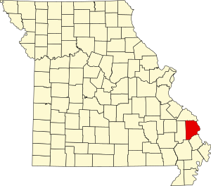 Location within the U.S. state of Missouri | |
 Missouri's location within the U.S. | |
| Coordinates: 37°23′N 89°41′W / 37.38°N 89.68°W | |
| Country | |
| State | |
| Founded | October 1, 1812 |
| Named for | Ensign Sieur Jean Baptiste de Girardot (also spelled Girardeau or Girardat) and a rock |
| Seat | Jackson |
| Largest city | Cape Girardeau |
| Area | |
| • Total | 586 sq mi (1,520 km2) |
| • Land | 579 sq mi (1,500 km2) |
| • Water | 7.8 sq mi (20 km2) 1.3% |
| Population (2020) | |
| • Total | 81,710 |
| • Density | 140/sq mi (54/km2) |
| Time zone | UTC−6 (Central) |
| • Summer (DST) | UTC−5 (CDT) |
| Congressional district | 8th |
| Website | www |

Cape Girardeau County is a county located in the southeastern part of the U.S. state of Missouri; its eastern border is formed by the Mississippi River. As of the 2020 U.S. Census, the population was 81,710.[1] The county seat is Jackson,[2] the first city in the US to be named in honor of President Andrew Jackson. Officially organized on October 1, 1812, the county is named after Ensign Sieur Jean Baptiste de Girardot, an official of the French colonial years. The "cape" in the county's name is named after a former promontory rock overlooking the Mississippi River; this feature was demolished during railroad construction. Cape Girardeau County is the hub of the Cape Girardeau–Jackson metropolitan area. Its largest city is Cape Girardeau.
History[]
Cape Girardeau County was organized on October 1, 1812, as one of five original counties in the Missouri Territory after the US made the Louisiana Purchase of 1803. It is named after Ensign Sieur Jean Baptiste de Girardot (also spelled Girardeau or Girardat), a French officer stationed 1704–1720 at Kaskaskia in the Illinois Country of New France. In 1733 he founded a trading post on the Mississippi River, which developed as the present-day city of Cape Girardeau.[3] The "cape" in the county name was a rock promontory overlooking the Mississippi River and Claire's house; the original cape rock was destroyed by railroad construction.
Jackson, Missouri is the county seat. The first Cape Girardeau County Courthouse was constructed in 1818 by John Davis. This courthouse burned in 1870. The present courthouse in Jackson was completed in 1908 and was designed by P.H. Weathers.
The county is the site of one of the oldest cold cases in the state of Missouri. Bonnie Huffman, a 20-year-old schoolteacher, was found murdered in a ditch just outside Delta on July 2, 1954. Her case was never solved.
Cape Girardeau is referenced in Dave Van Ronk's song "Hang Me, Oh Hang Me," which has found a place in the folk canon since its release in 1962. The song was featured prominently in the 2013 film Inside Llewyn Davis. In the second verse, the singer refers to having "been all around Cape Girardeau and parts of Arkansas...poor boy, I've been all around this world."
Geography[]
According to the U.S. Census Bureau, the county has a total area of 586 square miles (1,520 km2), of which 579 square miles (1,500 km2) is land and 7.8 square miles (20 km2) (1.3%) is water.[4]
The geography of Cape Girardeau County varies greatly. The areas around the towns of Delta and Dutchtown are flood plains, which were cultivated as cotton plantations. Western and northern areas are hilly and forested.
Adjacent counties[]
- Perry County (northwest)
- Union County, Illinois (northeast across the river)
- Alexander County, Illinois (east across the Mississippi River)
- Scott County (southeast)
- Stoddard County (south)
- Bollinger County (west)
Major highways[]
Demographics[]
| Historical population | |||
|---|---|---|---|
| Census | Pop. | %± | |
| 1820 | 5,968 | — | |
| 1830 | 7,445 | 24.7% | |
| 1840 | 9,359 | 25.7% | |
| 1850 | 13,912 | 48.6% | |
| 1860 | 15,547 | 11.8% | |
| 1870 | 17,558 | 12.9% | |
| 1880 | 20,998 | 19.6% | |
| 1890 | 22,060 | 5.1% | |
| 1900 | 24,315 | 10.2% | |
| 1910 | 27,621 | 13.6% | |
| 1920 | 29,839 | 8.0% | |
| 1930 | 33,203 | 11.3% | |
| 1940 | 37,775 | 13.8% | |
| 1950 | 38,397 | 1.6% | |
| 1960 | 42,020 | 9.4% | |
| 1970 | 49,350 | 17.4% | |
| 1980 | 58,837 | 19.2% | |
| 1990 | 61,633 | 4.8% | |
| 2000 | 68,693 | 11.5% | |
| 2010 | 75,674 | 10.2% | |
| 2020 | 81,710 | 8.0% | |
| U.S. Decennial Census[5] 1790-1960[6] 1900-1990[7] 1990-2000[8] 2010-2020[1] | |||
As of the census[9] of 2000, there were 68,693 people, 26,980 households, and 17,941 families residing in the county. The population density was 119 people per square mile (46/km2). There were 29,434 housing units at an average density of 51 per square mile (20/km2). The racial makeup of the county was 92.13% White, 5.28% Black or African American, 0.36% Native American, 0.75% Asian, 0.03% Pacific Islander, 0.31% from other races, and 1.15% from two or more races. Approximately 0.91% of the population were Hispanic or Latino of any race.
There were 26,980 households, out of which 31.20% had children under the age of 18 living with them, 53.80% were married couples living together, 9.80% had a female householder with no husband present, and 33.50% were non-families. 27.30% of all households were made up of individuals, and 10.10% had someone living alone who was 65 years of age or older. The average household size was 2.42 and the average family size was 2.96.
In the county, the population was spread out, with 23.40% under the age of 18, 13.40% from 18 to 24, 27.80% from 25 to 44, 21.60% from 45 to 64, and 13.80% who were 65 years of age or older. The median age was 35 years. For every 100 females, there were 93.20 males. For every 100 females age 18 and over, there were 90.00 males.
The median income for a household in the county was $45,862, and the median income for a family was $58,037. Males had a median income of $32,371 versus $20,833 for females. The per capita income for the county was $24,303. About 6.70% of families and 11.10% of the population were below the poverty line, including 11.40% of those under age 18 and 10.10% of those age 65 or over.
Religion[]
According to the Association of Religion Data Archives County Membership Report (2010), Cape Girardeau County is part of the Bible Belt, with evangelical Protestantism being the most predominant religion. The most predominant denominations among residents in Cape Girardeau County who adhere to a religion are Roman Catholics (19.19%), Assemblies of God (19.13%), and Lutherans (LCMS) (16.58%).
Education[]
Of adults 25 years of age and older in Cape Girardeau County, 81.1% possess a high school diploma or higher while 24.2% hold a bachelor's degree as their highest educational attainment.
Public schools[]
- Delta R-V School District—Delta
- Delta Elementary School (K–6)
- Delta High School (7–12)
- Oak Ridge R-VI School District—Oak Ridge
- Oak Ridge Elementary School (K–6)
- Oak Ridge High School (7–12)
- Nell Holcomb R-IV School District—Egypt Mills
- Nell Holcomb Elementary School (K–8)
- Jackson R-II School District—Jackson
- Gordonville Attendance Center (K–3)—Gordonville
- Millersville Attendance Center (K–3)—Millersville
- North Elementary School (K–5)
- Orchard Drive Elementary School (K–3)
- South Elementary School (PK–5)
- West Lane Elementary School (3–5)
- Jackson Middle School (6–7)
- Russell Hawkins Jr. High School (8–9)
- Jackson High School (10–12)
- Cape Girardeau Public Schools No. 63—Cape Girardeau
- Alma Schrader Elementary School (K–4)
- Blanchard Elementary School (K–4)
- Clippard Elementary School (K–4)
- Franklin Elementary School (K–4)
- Jefferson Elementary School (K–4)
- Cape Central Middle School (5–6)
- Cape Central Jr. High School (7–8)
- Cape Central High School (9–12)
- Cape Girardeau Career & Technology Center (10–12)
Private schools[]
- Cape Christian School (K–8)—Cape Girardeau; Assembly of God/Pentecostal
- St. Mary Cathedral School (K–8)—Cape Girardeau; Roman Catholic
- St. Vincent De Paul Elementary School (K–8)—Cape Girardeau; Roman Catholic
- Trinity Lutheran School (PK–8)—Cape Girardeau; Lutheran
- Immaculate Conception School (PK–8)—Jackson; Roman Catholic
- St. Paul Lutheran School (PK–8)—Jackson; Lutheran
- Eagle Ridge Christian School (PK–12)—Cape Girardeau; Non-denominational Christian
- Notre Dame Regional High School (9–12)—Cape Girardeau; Roman Catholic
- Saxony Lutheran High School (9–12)—Jackson/Fruitland; Lutheran
Post-secondary education[]
- Metro Business College—Cape Girardeau (Permanently Closed)
- Southeast Missouri State University—Cape Girardeau
Public libraries[]
Politics[]
Local[]
Since the late 20th century voters at the local level have switched from the Democratic Party to the Republican Party, which is now predominant in Cape Girardeau County. Republicans hold all of the elected positions in the county.
| Cape Girardeau County, Missouri | |||
|---|---|---|---|
| Elected countywide officials | |||
| Assessor | Robert Adams | Republican | |
| Auditor | Pete Frazier | Republican | |
| Circuit Clerk | Charlene Biester | Republican | |
| County Clerk | Kara Clark Summers | Republican | |
| Collector | Barbara Gholson | Republican | |
| Commissioner (Presiding) | Clint Tracy | Republican | |
| Commissioner (District 1) | Paul Koeper | Republican | |
| Commissioner (District 2) | Charles J. Herbst III | Republican | |
| Coroner | Wavis Jordan | Republican | |
| Prosecuting Attorney | Mark Welker | Republican | |
| Public Administrator | Lisa Reitzel | Republican | |
| Recorder | Drew Blattner | Republican | |
| Sheriff | Ruth Ann Dickerson | Republican | |
| Treasurer | Roger L. Hudson | Republican | |
State[]
| Year | Republican | Democratic | Third Parties |
|---|---|---|---|
| 2020 | 72.53% 29,127 | 25.58% 10,272 | 1.90% 762 |
| 2016 | 65.70% 24,209 | 31.31% 11,539 | 2.99% 1,101 |
| 2012 | 56.02% 19,797 | 41.56% 14,686 | 2.43% 857 |
| 2008 | 56.23% 20,672 | 41.75% 15,348 | 2.02% 744 |
| 2004 | 65.26% 22,433 | 33.49% 11,511 | 1.25% 429 |
| 2000 | 62.50% 18,543 | 35.36% 10,491 | 2.14% 635 |
| 1996 | 49.68% 13,781 | 48.38% 13,422 | 1.94% 538 |
| 1992 | 54.41% 15,080 | 45.59% 12,636 | 0.00% 0 |
| 1988 | 70.08% 17,336 | 29.50% 7,298 | 0.42% 104 |
| 1984 | 70.39% 17,299 | 29.61% 7,276 | 0.00% 0 |
| 1980 | 66.50% 16,197 | 33.11% 8,064 | 0.39% 96 |
| 1976 | 56.62% 13,079 | 43.35% 10,013 | 0.03% 7 |
| 1972 | 57.09% 12,656 | 42.05% 9,322 | 0.85% 189 |
| 1968 | 37.96% 7,217 | 62.04% 11,795 | 0.00% 0 |
| 1964 | 42.74% 8,506 | 57.26% 11,396 | 0.00% 0 |
| 1960 | 49.07% 9,384 | 50.93% 9,739 | 0.00% 0 |
In the Missouri House of Representatives, Cape Girardeau County is divided into two legislative districts, both of which are represented by Republicans.
- District 146 – Consists of most of the entire county outside of the city of Cape Girardeau, although a small portion of the northern edge of the city is included in this district. The district also takes in all of the city of Jackson as well as the communities of Pocahontas, Oak Ridge, Old Appleton, Gordonville, Dutchtown, Delta, Allenville, and Whitewater. It is currently represented by Barry Hovis (R-Whitewater).
| Party | Candidate | Votes | % | ±% | |
|---|---|---|---|---|---|
| Republican | Barry Hovis | 21,012 | 100.00% | +18.11 | |
| Party | Candidate | Votes | % | ±% | |
|---|---|---|---|---|---|
| Republican | Barry Hovis | 15,289 | 81.89% | -18.11 | |
| Democratic | Gayla Dace | 3,381 | 18.11% | +18.11 | |
- District 147 – Consists of most of the city of Cape Girardeau and a small sliver of the mostly rural stretch of Highway 74 to Dutchtown. It is currently represented by Wayne Wallingford (R-Cape Girardeau).
| Party | Candidate | Votes | % | ±% | |
|---|---|---|---|---|---|
| Republican | Wayne Wallingford | 10,167 | 63.14% | -1.64 | |
| Democratic | Andy Leighton | 5,935 | 36.86% | +1.64 | |
| Party | Candidate | Votes | % | ±% | |
|---|---|---|---|---|---|
| Republican | Kathy Swan | 8,616 | 64.78% | -8.88 | |
| Democratic | Renita Green | 4,685 | 35.22% | +8.88 | |
In the Missouri Senate, all of Cape Girardeau County is a part of Missouri's 27h District and is currently represented by Holly Thompson Rehder (R-Sikeston.
| Party | Candidate | Votes | % | ±% | |
|---|---|---|---|---|---|
| Republican | Holly Rehder | 28,941 | 73.58% | -2.01 | |
| Democratic | Donnie Owens | 10,391 | 26.42% | +2.01 | |
| Party | Candidate | Votes | % | ±% | |
|---|---|---|---|---|---|
| Republican | Wayne Wallingford | 27,062 | 75.59% | ' | |
| Democratic | Donnie Owens | 8,739 | 24.41% | ||
Federal[]
All of Cape Girardeau County is included in Missouri's 8th Congressional District and is currently represented by Jason Smith (R-Salem) in the U.S. House of Representatives. Smith was elected to a fifth term in 2020 over Democratic challenger Kathy Ellis.
| Party | Candidate | Votes | % | ±% | |
|---|---|---|---|---|---|
| Republican | Jason Smith | 29,028 | 72.93% | -0.54 | |
| Democratic | Kathy Ellis | 10,036 | 25.21% | +0.25 | |
| Libertarian | Tom Schmitz | 739 | 1.86% | +0.29 | |
| Party | Candidate | Votes | % | ±% | |
|---|---|---|---|---|---|
| Republican | Jason Smith | 23,687 | 73.47% | -0.94 | |
| Democratic | Kathy Ellis | 8,048 | 24.96% | +2.66 | |
| Libertarian | Jonathan L. Shell | 505 | 1.57% | -1.72 | |
Cape Girardeau County, along with the rest of the state of Missouri, is represented in the U.S. Senate by Josh Hawley (R-Columbia) and Roy Blunt (R-Strafford).
| Party | Candidate | Votes | % | ±% | |
|---|---|---|---|---|---|
| Republican | Josh Hawley | 22,964 | 70.65% | +16.98 | |
| Democratic | Claire McCaskill | 8,886 | 27.34% | -13.49 | |
| Libertarian | Japheth Campbell | 307 | 0.95% | -4.55 | |
| Independent | Craig O'Dear | 232 | 0.71% | ||
| Green | Jo Crain | 114 | 0.35% | +0.35 | |
Blunt was elected to a second term in 2016 over then-Missouri Secretary of State Jason Kander.
| Party | Candidate | Votes | % | ±% | |
|---|---|---|---|---|---|
| Republican | Roy Blunt | 24,173 | 65.66% | ||
| Democratic | Jason Kander | 11,219 | 30.47% | ||
| Libertarian | Jonathan Dine | 863 | 2.34% | ||
| Green | Johnathan McFarland | 289 | 0.79% | ||
| Constitution | Fred Ryman | 268 | 0.73% | ||
Political culture[]
Unusually for a rural Southern county (straddling the Mississippi embayment), Cape Girardeau County has generally voted Republican since the Civil War. After voting for Lincoln in 1864 and Grant in 1868, it did vote Democratic four times in a row; but from 1888 on, it has voted Democratic only in Franklin Roosevelt's and Lyndon Johnson's landslides of 1932, 1936, and 1964; in the three-way race in 1912 (when it gave Wilson a plurality); and for Missouri native Harry Truman in 1948.[14]
Like most areas throughout rural Missouri, voters in Cape Girardeau County generally adhere to socially and culturally conservative principles which have influenced their shift to Republicans. In 2004, Missourians voted on a constitutional amendment to define marriage as the union between a man and a woman—it overwhelmingly passed Cape Girardeau County with 83.19 percent of the vote. The initiative passed the state with 71 percent of support, as Missouri became the first state to ban same-sex marriage. In 2006, Cape Girardeau County voted against a state constitutional amendment to fund and legalize embryonic stem cell research, with 63.12 percent opposed. The initiative narrowly passed the state with 51 percent of support, and Missouri became one of the first states to approve such research. Cape Girardeau County's voters have supported such populist causes as increasing the minimum wage. In 2006, Cape Girardeau County voted to increase the minimum wage to $6.50 an hour with 60.04 percent of the vote. The proposition strongly passed every county in Missouri, with 75.94 percent voting in favor. (During the same election, voters in five other states also strongly approved increases in the minimum wage.)
Missouri presidential preference primaries[]
2020[]
The 2020 presidential primaries for both the Democratic and Republican parties were held in Missouri on March 10. On the Democratic side, former Vice President Joe Biden (D-Delaware) both won statewide and carried Cape Girardeau County by a wide margin. Biden went on to defeat President Donald Trump in the general election.
| Party | Candidate | Votes | % | ±% | |
|---|---|---|---|---|---|
| Democratic | Joe Biden | 3,030 | 56.54 | ||
| Democratic | Bernie Sanders | 2,064 | 38.52 | ||
| Democratic | Tulsi Gabbard | 50 | 0.93 | ||
| Democratic | Others/Uncommitted | 215 | 4.01 | ||
Incumbent President Donald Trump (R-Florida) faced a primary challenge from former Massachusetts Governor Bill Weld, but won both Cape Girardeau County and statewide by overwhelming margins.
| Party | Candidate | Votes | % | ±% | |
|---|---|---|---|---|---|
| Republican | Donald Trump | 5,277 | 98.05 | ||
| Republican | Bill Weld | 21 | 0.39 | ||
| Republican | Others/Uncommitted | 84 | 1.56 | ||
2016[]
The 2016 presidential primaries for both the Republican and Democratic parties were held in Missouri on March 15. Businessman Donald Trump (R-New York) narrowly won the state overall, but Senator Ted Cruz (R-Texas) carried a plurality of the vote in Cape Girardeau County. Trump went on to win the nomination and the presidency.
| Party | Candidate | Votes | % | ±% | |
|---|---|---|---|---|---|
| Republican | Ted Cruz | 7,404 | 46.61 | ||
| Republican | Donald Trump | 6,192 | 38.98 | ||
| Republican | John Kasich | 1,257 | 7.91 | ||
| Republican | Marco Rubio | 701 | 4.41 | ||
| Republican | Others/Uncommitted | 330 | 2.08 | ||
On the Democratic side, former Secretary of State Hillary Clinton (D-New York) narrowly won statewide, but Senator Bernie Sanders (I-Vermont) carried a majority of the vote in Cape Girardeau County.
| Party | Candidate | Votes | % | ±% | |
|---|---|---|---|---|---|
| Democratic | Bernie Sanders | 2,375 | 52.36 | ||
| Democratic | Hillary Clinton | 2,116 | 46.65 | ||
| Democratic | Others/Uncommitted | 45 | 0.99 | ||
2012[]
The 2012 Missouri Republican Presidential Primary's results were nonbinding on the state's national convention delegates. Voters in Cape Girardeau County supported former U.S. Senator Rick Santorum (R-Pennsylvania), who finished first in the state at large, but eventually lost the nomination to former Governor Mitt Romney (R-Massachusetts). Delegates to the congressional district and state conventions were chosen at a county caucus, which selected a delegation favoring Santorum. Incumbent President Barack Obama easily won the Missouri Democratic Primary and renomination. He defeated Romney in the general election.
2008[]
In 2008, the Missouri Republican Presidential Primary was closely contested, with Senator John McCain (R-Arizona) prevailing and eventually winning the nomination. However, former Governor Mitt Romney (R-Massachusetts) won a plurality in Cape Girardeau County.
| Party | Candidate | Votes | % | ±% | |
|---|---|---|---|---|---|
| Republican | Mitt Romney | 3,922 | 35.32 | ||
| Republican | John McCain | 3,528 | 31.77 | ||
| Republican | Mike Huckabee | 3,068 | 27.63 | ||
| Republican | Ron Paul | 361 | 3.25 | ||
| Republican | Others/Uncommitted | 226 | 2.04 | ||
Then-Senator Hillary Clinton (D-New York) received more votes than any candidate from either party in Cape Girardeau County during the 2008 presidential primary. Despite initial reports that Clinton had won Missouri, Barack Obama (D-Illinois), also a Senator at the time, narrowly defeated her statewide and later became that year's Democratic nominee, going on to win the presidency.
| Party | Candidate | Votes | % | ±% | |
|---|---|---|---|---|---|
| Democratic | Hillary Clinton | 4,510 | 56.55 | ||
| Democratic | Barack Obama | 3,145 | 39.44 | ||
| Democratic | Others/Uncommitted | 320 | 4.02 | ||
Communities[]
Cities[]
- Cape Girardeau (small part in Scott County)
- Delta
- Jackson (county seat)
- Scott City (mostly in Scott County)
Villages[]
Unincorporated communities[]
Notable people[]
- Jacob M. Appel, novelist
- William F. Barnes, former head football coach for UCLA
- Leon Brinkopf, former professional baseball player
- Joseph Cable, a Medal of Honor recipient during the American Indian Wars
- Shirley Crites, All-American Girls Professional Baseball League player
- Dale Dye, Actor and retired U.S. Marine
- A.J. Ellis, former Major League Baseball catcher
- John Thomson Faris, clergyman
- Gary Friedrich, writer of the comic book Ghost Rider
- Linda M. Godwin, NASA astronaut and scientist
- Chic Hecht, U.S. Senator from Nevada (1983-1989) and Ambassador to the Bahamas (1989-1993)
- Edwin C. Horrell, American football player and coach
- Andrew Conway Ivy, President of the American Physiological Society (1939–1941)
- Terry Jones, fundamentalist pastor of Dove World Outreach Center
- Peter Kinder, 46th Lieutenant Governor of Missouri (2005–2017)
- Richard Kinder, businessman and co-founder and executive chairman of Kinder Morgan, Inc.
- The Limbaugh family, including political commentators, brothers David and Rush Limbaugh
- Mark Littell, Former professional baseball pitcher
- Fred Henry McGuire, Medal of Honor recipient for his role in the Philippine–American War
- Marie Elizabeth Watkins Oliver, "the Betsy Ross of Missouri," designer and creator of the Missouri State Flag
- Stephanie O'Sullivan, Principal Deputy Director of National Intelligence
- Susan Beth Scott, 2008 and 2012 U.S. Paralympic Medalist Swimmer
- John Locke Scripps, journalist and biographer
- Tony Spinner, guitarist and singer
- Jess Stacy, jazz pianist
- William S. Stone, former Superintendent of the U.S. Air Force Academy
- Billy Swan, singer of #1 hit song "I Can Help" in 1974
- Terry Teachout, writer
- Roy Thomas, comic book writer (Marvel and DC Comics) and editor (Marvel), screenwriter
- Louis C. Wagner, Jr., United States Army four-star general
- Robert Henry Whitelaw, U.S. Congressman from Missouri (1890-1891)
See also[]
References[]
- ^ Jump up to: a b "2020 Population and Housing State Data". United States Census Bureau. Retrieved September 3, 2021.
- ^ "Find a County". National Association of Counties. Archived from the original on 2011-05-31. Retrieved 2011-06-07.
- ^ Eaton, David Wolfe (1916). How Missouri Counties, Towns and Streams Were Named. The State Historical Society of Missouri. p. 270.
- ^ "2010 Census Gazetteer Files". United States Census Bureau. August 22, 2012. Archived from the original on October 21, 2013. Retrieved November 14, 2014.
- ^ "U.S. Decennial Census". United States Census Bureau. Retrieved November 14, 2014.
- ^ "Historical Census Browser". University of Virginia Library. Retrieved November 14, 2014.
- ^ "Population of Counties by Decennial Census: 1900 to 1990". United States Census Bureau. Retrieved November 14, 2014.
- ^ "Census 2000 PHC-T-4. Ranking Tables for Counties: 1990 and 2000" (PDF). United States Census Bureau. Retrieved November 14, 2014.
- ^ "U.S. Census website". United States Census Bureau. Retrieved 2011-05-14.
- ^ Breeding, Marshall. "Cape Girardeau Public Library". Libraries.org. Retrieved May 8, 2017.
- ^ Breeding, Marshall. "Jackson Public Library". Libraries.org. Retrieved May 8, 2017.
- ^ Breeding, Marshall. "Riverside Regional Library". Libraries.org. Retrieved May 8, 2017.
- ^ Leip, David. "Dave Leip's Atlas of U.S. Presidential Elections". uselectionatlas.org. Retrieved 2018-03-24.
- ^ "County winners, 1836-2016". Google Docs. Retrieved 2021-01-16.
External links[]
- Digitized 1930 Plat Book of Cape Girardeau County Archived 2011-08-16 at the Wayback Machine from University of Missouri Division of Special Collections, Archives, and Rare Books
| show Places adjacent to Cape Girardeau County, Missouri |
|---|
| show Municipalities and communities of Cape Girardeau County, Missouri, United States |
|---|

| show Geographical features of Cape Girardeau County, Missouri |
|---|

Coordinates: 37°23′N 89°41′W / 37.38°N 89.68°W
| show Authority control |
|---|
- Missouri counties
- Cape Girardeau County, Missouri
- Cape Girardeau–Jackson metropolitan area
- Missouri counties on the Mississippi River
- 1812 establishments in Missouri Territory
- Populated places established in 1812