Collobrières
Collobrières | |
|---|---|
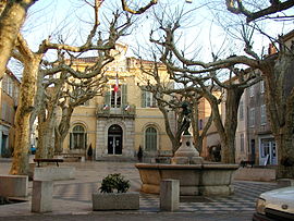 The Place de la Libération in Collobrieres | |
 Coat of arms | |
show Location of Collobrières | |
 Collobrières | |
| Coordinates: 43°14′17″N 6°18′35″E / 43.2381°N 6.3097°ECoordinates: 43°14′17″N 6°18′35″E / 43.2381°N 6.3097°E | |
| Country | France |
| Region | Provence-Alpes-Côte d'Azur |
| Department | Var |
| Arrondissement | Toulon |
| Canton | Le Luc |
| Government | |
| • Mayor (2020–2026) | Christine Amrane[1] |
| Area 1 | 112.68 km2 (43.51 sq mi) |
| Population (Jan. 2018)[2] | 1,891 |
| • Density | 17/km2 (43/sq mi) |
| Time zone | UTC+01:00 (CET) |
| • Summer (DST) | UTC+02:00 (CEST) |
| INSEE/Postal code | 83043 /83610 |
| Elevation | 58–776 m (190–2,546 ft) (avg. 131 m or 430 ft) |
| 1 French Land Register data, which excludes lakes, ponds, glaciers > 1 km2 (0.386 sq mi or 247 acres) and river estuaries. | |


Collobrières (French pronunciation: [kɔlɔbʁijɛʁ]; Occitan: Colobrieras) is a commune in the Var department in the Provence-Alpes-Côte d'Azur region in southeastern France.
Main exports[]
Collobrières main exports are edible chestnuts which are made into things like marron glacé and ice cream. They also grow trees for cork production.
See also[]
- Communes of the Var department
References[]
- ^ "Répertoire national des élus: les maires". data.gouv.fr, Plateforme ouverte des données publiques françaises (in French). 2 December 2020. Retrieved 7 December 2020.
- ^ "Populations légales 2018". INSEE. 28 December 2020.
| Wikimedia Commons has media related to Collobrières. |
This Var geographical article is a stub. You can help Wikipedia by . |
Categories:
- Communes of Var (department)
- Var (department) geography stubs