Montferrat, Var
Montferrat | |
|---|---|
 The town hall of Montferrat | |
 Coat of arms | |
show Location of Montferrat | |
 Montferrat | |
| Coordinates: 43°36′45″N 6°28′55″E / 43.6125°N 6.4819°ECoordinates: 43°36′45″N 6°28′55″E / 43.6125°N 6.4819°E | |
| Country | France |
| Region | Provence-Alpes-Côte d'Azur |
| Department | Var |
| Arrondissement | Draguignan |
| Canton | Flayosc |
| Intercommunality | CA Dracénie Provence Verdon |
| Government | |
| • Mayor (2020–2026) | Raymond Gras[1] |
| Area 1 | 34.01 km2 (13.13 sq mi) |
| Population (Jan. 2018)[2] | 1,538 |
| • Density | 45/km2 (120/sq mi) |
| Time zone | UTC+01:00 (CET) |
| • Summer (DST) | UTC+02:00 (CEST) |
| INSEE/Postal code | 83082 /83131 |
| Elevation | 420–952 m (1,378–3,123 ft) (avg. 480 m or 1,570 ft) |
| 1 French Land Register data, which excludes lakes, ponds, glaciers > 1 km2 (0.386 sq mi or 247 acres) and river estuaries. | |


Montferrat (French pronunciation: [mɔ̃fɛʁa]) is a commune in the Var department in the Provence-Alpes-Côte d'Azur region in southeastern France.
See also[]
- Communes of the Var department
Notable buildings[]
- Church of Saint-Roch.[3]
- Chapelle Notre-Dame de Beauvoir, perched at 660m altitude.
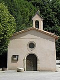
Church of St. Roch.

Chapelle Notre-Dame de Beauvoir.


References[]
- ^ "Répertoire national des élus: les maires". data.gouv.fr, Plateforme ouverte des données publiques françaises (in French). 2 December 2020. Retrieved 7 December 2020.
- ^ "Populations légales 2018". INSEE. 28 December 2020.
- ^ [1]
| Wikimedia Commons has media related to Montferrat (Var). |
This Var geographical article is a stub. You can help Wikipedia by . |
Categories:
- Communes of Var (department)
- Var (department) geography stubs