Les Mayons
Les Mayons | |
|---|---|
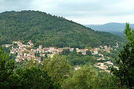 A general view of Les Mayons | |
 Coat of arms | |
show Location of Les Mayons | |
 Les Mayons | |
| Coordinates: 43°18′50″N 6°21′31″E / 43.3139°N 6.3586°ECoordinates: 43°18′50″N 6°21′31″E / 43.3139°N 6.3586°E | |
| Country | France |
| Region | Provence-Alpes-Côte d'Azur |
| Department | Var |
| Arrondissement | Brignoles |
| Canton | Le Luc |
| Intercommunality | Cœur du Var |
| Government | |
| • Mayor (2020–2026) | Michel Mondani[1] |
| Area 1 | 28.86 km2 (11.14 sq mi) |
| Population (Jan. 2018)[2] | 638 |
| • Density | 22/km2 (57/sq mi) |
| Time zone | UTC+01:00 (CET) |
| • Summer (DST) | UTC+02:00 (CEST) |
| INSEE/Postal code | 83075 /83340 |
| Elevation | 79–742 m (259–2,434 ft) (avg. 194 m or 636 ft) |
| 1 French Land Register data, which excludes lakes, ponds, glaciers > 1 km2 (0.386 sq mi or 247 acres) and river estuaries. | |


Les Mayons (French pronunciation: [le majɔ̃]; Occitan: Lei Maions) is a commune in the Var department in the Provence-Alpes-Côte d'Azur region in southeastern France.
It lies approximately 30 km from St Tropez and 10 km from Le Luc.
See also[]
- Communes of the Var department
References[]
- ^ "Répertoire national des élus: les maires". data.gouv.fr, Plateforme ouverte des données publiques françaises (in French). 2 December 2020. Retrieved 7 December 2020.
- ^ "Populations légales 2018". INSEE. 28 December 2020.
| Wikimedia Commons has media related to Les Mayons. |
This Var geographical article is a stub. You can help Wikipedia by . |
Categories:
- Communes of Var (department)
- Var (department) geography stubs