Pourcieux
Pourcieux | |
|---|---|
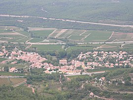 The village seen from Mount Aurélien | |
 Coat of arms | |
show Location of Pourcieux | |
 Pourcieux | |
| Coordinates: 43°28′12″N 5°47′10″E / 43.4701°N 5.7861°ECoordinates: 43°28′12″N 5°47′10″E / 43.4701°N 5.7861°E | |
| Country | France |
| Region | Provence-Alpes-Côte d'Azur |
| Department | Var |
| Arrondissement | Brignoles |
| Canton | Saint-Maximin-la-Sainte-Baume |
| Intercommunality | CA Provence Verte |
| Government | |
| • Mayor (2020–2026) | Claude Porzio[1] |
| Area 1 | 21.23 km2 (8.20 sq mi) |
| Population (Jan. 2018)[2] | 1,571 |
| • Density | 74/km2 (190/sq mi) |
| Time zone | UTC+01:00 (CET) |
| • Summer (DST) | UTC+02:00 (CEST) |
| INSEE/Postal code | 83096 /83470 |
| Elevation | 278–870 m (912–2,854 ft) (avg. 350 m or 1,150 ft) |
| 1 French Land Register data, which excludes lakes, ponds, glaciers > 1 km2 (0.386 sq mi or 247 acres) and river estuaries. | |


Pourcieux (French pronunciation: [puʁsjø]; Occitan: Porcièu) is a commune in the Var department in the Provence-Alpes-Côte d'Azur region in southeastern France.
The small village provides a typical image of the Provence of Frédéric Mistral, with vine-grower's houses built around a castle, and a town square and fountain shaded by hundred year-old plane trees. Its sunny hillsides sit at the foot of the , a short distance from the Montagne Sainte-Victoire made famous by Paul Cézanne.
See also[]
- Communes of the Var department
References[]
- ^ "Répertoire national des élus: les maires". data.gouv.fr, Plateforme ouverte des données publiques françaises (in French). 2 December 2020. Retrieved 7 December 2020.
- ^ "Populations légales 2018". INSEE. 28 December 2020.
| Wikimedia Commons has media related to Pourcieux. |
This Var geographical article is a stub. You can help Wikipedia by . |
Categories:
- Communes of Var (department)
- Var (department) geography stubs