Daradgee, Queensland
| Daradgee Queensland | |||||||||||||||
|---|---|---|---|---|---|---|---|---|---|---|---|---|---|---|---|
 Daradgee railway bridge under construction, 1924 | |||||||||||||||
 Daradgee | |||||||||||||||
| Coordinates | 17°29′15″S 146°00′23″E / 17.4875°S 146.0063°E | ||||||||||||||
| Population | 74 (2016 census)[1] | ||||||||||||||
| • Density | 7.63/km2 (19.76/sq mi) | ||||||||||||||
| Postcode(s) | 4860 | ||||||||||||||
| Area | 9.7 km2 (3.7 sq mi) | ||||||||||||||
| Time zone | AEST (UTC+10:00) | ||||||||||||||
| Location |
| ||||||||||||||
| LGA(s) | Cassowary Coast Region | ||||||||||||||
| State electorate(s) | Hill | ||||||||||||||
| Federal division(s) | Kennedy | ||||||||||||||
| |||||||||||||||

Daradgee is a rural town and locality in the Cassowary Coast Region, Queensland, Australia.[2][3] In the 2016 census, Daradgee had a population of 74 people.[1]
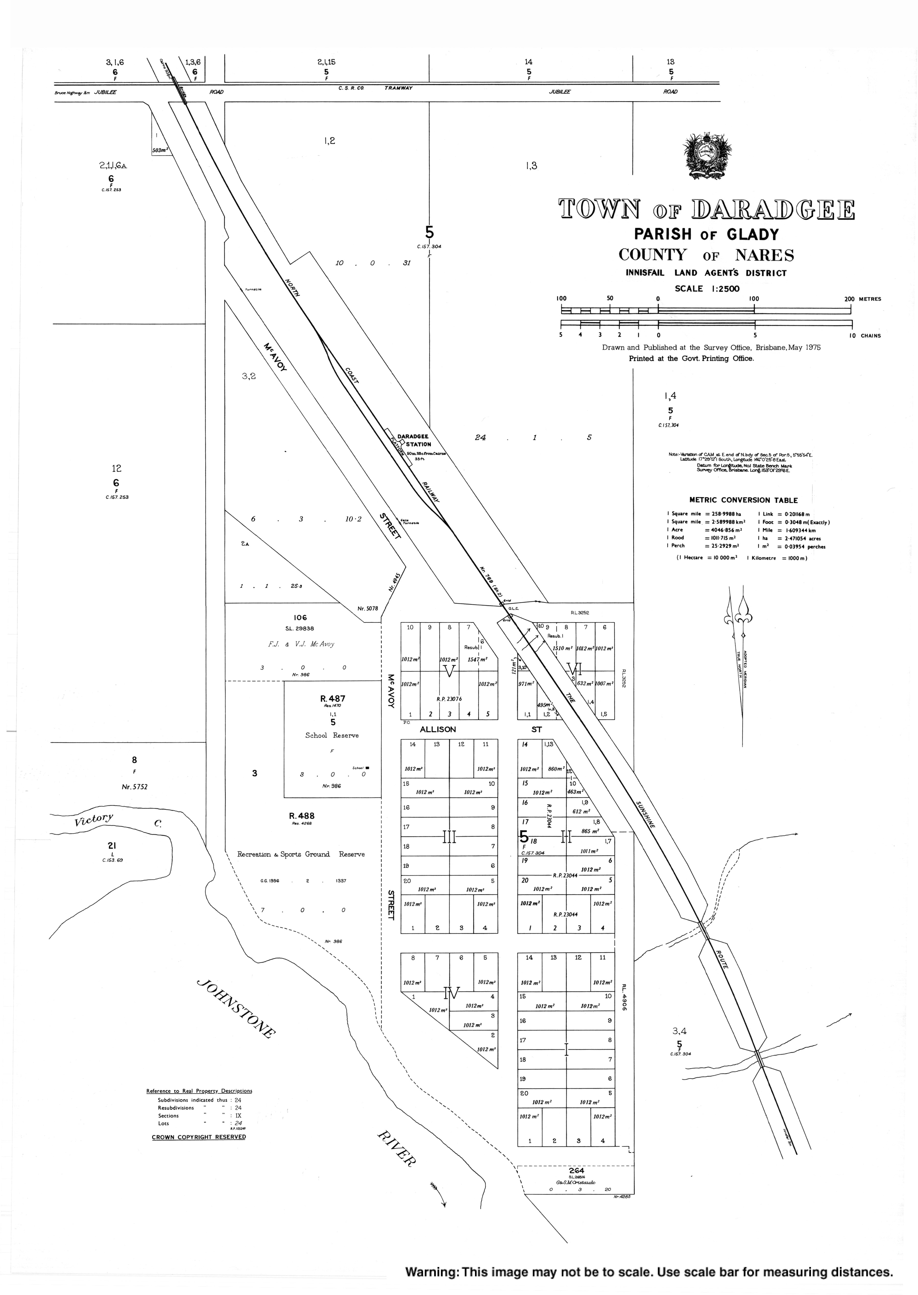
Geography[]
The locality is bounded in the south-east by the Johnstone River. Victory Creek flows through the locality; it is a tributary of the Johnstone River at 17°29′15″S 146°00′12″E / 17.4876°S 146.0034°E.[4] Alligator Point is a point immediately across the river from the mouth of Victory Creek where the river has a sharp bend (17°29′20″S 146°00′11″E / 17.4889°S 146.0030°E).[5][6]
The land is relatively flat and low-lying (approx 10 metres above sea level) and is used for cropping including sugarcane and bananas.[7]
The Bruce Highway runs through the south-west corner of the locality while the North Coast railway line runs from south to north through the locality. There is a cane tramway to deliver harvested sugarcane to the local sugar mills.[7]
History[]

The town name is a corruption of the original township name Daraji (used from 1905 to 1918) based on an Aboriginal word meaning burial ground.[2][3]
Daradgee Provisional School opened on 10 July 1911. In 1915 it became Daradgee State School. It closed on 14 December 1984.[8]
The final section of the North Coast railway line was the bridge at Daradgee across the Johnstone River. The bridge was opened on 8 December 1924, by the Queensland Premier, Ted Theodore, enabling rail travel from Cairns to Brisbane and from there to as far as Perth in Western Australia.[9][10][11]
In the 2016 census, Daradgee had a population of 74 people.[1]
Education[]
Daradgee Environmental Education Centre is a special purpose facility at McAvoy Street (17°29′12″S 146°00′19″E / 17.4866°S 146.0053°E).[12][13] It operates on the site of the former Daradgee State School using some of its buildings.[14]
There are no regular schools in Daradgee. The nearest primary schools are Goondi State School in Goondi Bend to the south and Innisfail State School in Innisfail to the south-east. The nearest government secondary school is Innisfail State College in Innisfail Estate to the south-east. Catholic primary and secondary schools are in Innisfail.[7]
References[]
- ^ a b c Australian Bureau of Statistics (27 June 2017). "Daradgee (SSC)". 2016 Census QuickStats. Retrieved 20 October 2018.

- ^ a b "Daradgee – town in Cassowary Coast Region (entry 9334)". Queensland Place Names. Queensland Government. Retrieved 18 September 2020.
- ^ a b "Daradgee – locality in Cassowary Coast Region (entry 45692)". Queensland Place Names. Queensland Government. Retrieved 18 September 2020.
- ^ "Victory Creek – watercourse in Cassowary Coast Regional (entry 36028)". Queensland Place Names. Queensland Government. Retrieved 18 September 2020.
- ^ "Alligator Point – point in Cassowary Coast Regional (entry 401)". Queensland Place Names. Queensland Government. Retrieved 18 September 2020.
- ^ "Parish of Glady" (Map). Queensland Government. 1976. Archived from the original on 30 September 2020. Retrieved 30 September 2020.
- ^ a b c "Queensland Globe". State of Queensland. Retrieved 30 September 2020.
- ^ Queensland Family History Society (2010), Queensland schools past and present (Version 1.01 ed.), Queensland Family History Society, ISBN 978-1-921171-26-0
- ^ "OFFICIAL OPENING OF THE NORTH COAST LINE". Cairns Post. Vol. XXXV, no. 5055. Queensland, Australia. 9 December 1924. p. 5. Retrieved 15 December 2017 – via National Library of Australia.
- ^ "DARADGEE BRIDGE". Cairns Post. Vol. XXXV, no. 5055. Queensland, Australia. 9 December 1924. p. 5. Archived from the original on 30 September 2020. Retrieved 15 December 2017 – via National Library of Australia.
- ^ "From Cairns to Perth". Sydney Mail. Vol. XXVI, no. 665. New South Wales, Australia. 24 December 1924. p. 14. Archived from the original on 30 September 2020. Retrieved 15 December 2017 – via National Library of Australia.
- ^ "State and non-state school details". Queensland Government. 9 July 2018. Archived from the original on 21 November 2018. Retrieved 21 November 2018.
- ^ "Daradgee Environmental Education Centre". Archived from the original on 30 September 2020. Retrieved 21 November 2018.
- ^ "About us". Daradgee Environmental Education Centre. 21 May 2019. Archived from the original on 21 March 2019. Retrieved 30 September 2020.
External links[]
| Wikimedia Commons has media related to Daradgee, Queensland. |
- Towns in Queensland
- Cassowary Coast Region
- Localities in Queensland