Eidskog
Eidskog kommune | |
|---|---|
 | |
 Coat of arms  Innlandet within Norway | |
 Eidskog within Innlandet | |
| Coordinates: 59°59′53″N 12°3′38″E / 59.99806°N 12.06056°ECoordinates: 59°59′53″N 12°3′38″E / 59.99806°N 12.06056°E | |
| Country | Norway |
| County | Innlandet |
| District | Glåmdal |
| Administrative centre | Skotterud |
| Government | |
| • Mayor (2007) | Knut Gustav Woie (Sp) |
| Area | |
| • Total | 641 km2 (247 sq mi) |
| • Land | 604 km2 (233 sq mi) |
| Area rank | 174 in Norway |
| Population (2004) | |
| • Total | 6,431 |
| • Rank | 154 in Norway |
| • Density | 11/km2 (30/sq mi) |
| • Change (10 years) | −0.1% |
| Demonym(s) | Eidskoging[1] |
| Time zone | UTC+01:00 (CET) |
| • Summer (DST) | UTC+02:00 (CEST) |
| ISO 3166 code | NO-3416 |
| Official language form | Bokmål[2] |
| Website | www |

Eidskog is a municipality in Innlandet county, Norway. It is part of the traditional region of Glåmdal. The administrative centre of the municipality is the village of Skotterud. Eidskog was separated from the municipality of Vinger in 1864.
The municipality is located in the southerneastern end of Innlandet county. It is bordered to the north by the municipality of Kongsvinger and in the west by Aurskog-Høland, Nes and Sør-Odal. Eidskog borders on Sweden, both to the east and south.
General information[]
Name[]
The Old Norse form of the name was Eiðaskógr. The first element is the plural genitive case of eið which means "path between two lakes". The last element is skógr which means "woods". Thus "the woods with the many eiðs". (In old times people travelled in small boats on the lakes and the rivers, but they had to drag the boats over the eids.)
Coat of arms[]
The coat of arms is from modern times. It was granted on 12 September 1986. The arms show a gray background with a black grouse, a common inhabitant of the many forests in the municipality. Forestry is also one of the main sources of income in the area.[3]
Ethnic and foreign minority[]
| Ancestry | Number |
|---|---|
| 138 | |
| 33 | |
| 29 | |
| 26 | |
| 24 | |
| 23 | |
| 21 |
History[]
The name Eidskog is ancient and was used for the region between today's Kongsvinger in Norway and Arvika in Sweden. Eskoleia, the route through Eidskog, was (and continues to be in the form of Riksvei 2) one of the most important traffic arteries between Norway and Sweden. The name was already in use during the saga period and became, after the canonization of Saint Olaf and important pilgrim's route from Europe to Nidaros. At Midtskog (Norwegian: middle of the woods), today called Matrand, a stave church was raised in the 12th century. Today, Eidskog church is built on the same site and was constructed in 1665.
The way through Eidskog was also militarily important and many times through history has been the point of Swedish strikes into Hedmark. To defend against these assaults, a number of fortifications were built in the vicinity, including ones at Magnor and Matrand, but the chief fortification was Kongsvinger Fortress.
The last Swedish attack through Eidskog was in 1814 when Major General Carl Pontus Gahn on July 31 crossed the border and marched against Kongsvinger. His forces were stopped at Lier outside Kongsvinger on August 2 by troops led by Lieutenant Colonel Andreas Samuel Krebs (1769-1818) and retreated to Eidskog. On August 4, Krebs followed after to drive Swedish troops off Norwegian territory. The two forces met in the Battle of Matrand which was the bloodiest battle of the war and ended with a Norwegian victory.
Later in 1814, Norway was joined in union with Sweden and the confrontations at the Eidskog border ended.
The Soot Canal, constructed in 1849, has Norway's oldest sluice gates. It was the work of Engebret Soot (1786–1859). It was built to allow timber to be transported (floated) to the Halden sawmills. The canal was 1.5 kilometres (0.9 mi) long and had 16 locks which extended from Lake Skjervangen at 185 metres (607 ft) above sea level up to Lake Mortsjølungen at 201 metres (659 ft) above sea level.
The route through Eidskog became an important connection between the two countries; this was strengthened with the opening of the Grenseban railway in 1862, which connected Christiania to Stockholm.
Eidskog became an independent municipality in 1864 when it was separated from Vinger municipality. The new municipality then had 6,920 inhabitants.

Attractions[]
- Soot Canal - the first lock constructed in Norway, used for log floating
- Grenselosmuseet - museum on the route for escape to Sweden during the World War II
- Oppistun Børli - poet Hans Børli's home
- Morokulien - memorial to the long lasting peace with Sweden
- Rønning Treski - last wood ski producer in Norway
Notable residents[]
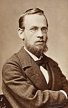
- Erik Werenskiold (1855 in Eidskog – 1938) a Norwegian painter and illustrator
- Konrad Hirsch (1900 in Eidskog – 1924) Swedish footballer, played in 1924 Summer Olympics
- Julla Sæthern (1901 in Eidskog – 1981) a Norwegian barrister, feminist and politician
- Hans Børli (1918 at Eidskog – 1989) a Norwegian poet, writer and lumberjack
- Torgrim Sollid (born 1942 in Eidskog) a composer and folk and jazz musician
- Ivar Skulstad (born 1953) politician, Mayor of Eidskog 1999 to 2005
- Kristin Solli Schøien (born 1954) an author and composer, lives in Eidskog
- Max Ivan Lindkjølen (born 1956) chef and entrepreneur [5]
- Remi Eriksen (born 1967) Group President and CEO of DNV GL, a classification society
- Wilhelm Brenna (born 1979) a retired Norwegian ski jumper, junior world champion
- Andreas Ulvo (born 1983) a jazz pianist, organist, keyboardist and composer
References[]
- ^ "Navn på steder og personer: Innbyggjarnamn" (in Norwegian). Språkrådet.
- ^ "Forskrift om målvedtak i kommunar og fylkeskommunar" (in Norwegian). Lovdata.no.
- ^ Norske Kommunevåpen (1990). "Nye kommunevåbener i Norden". Retrieved 2008-12-21.
- ^ "Immigrants and Norwegian-born to immigrant parents, by immigration category, country background and percentages of the population". ssb.no. Archived from the original on 29 July 2017. Retrieved 29 June 2015.
- ^ "Om Oss" (nb-NO). MaxIvan (2012-06-22). Retrieved 2019-06-15.
External links[]
 Media related to Eidskog at Wikimedia Commons
 The dictionary definition of Eidskog at Wiktionary
- Municipal fact sheet from Statistics Norway
- Culture in Eidskog on the map (in Norwegian)
| hide | |||||||||||||||||||||
|---|---|---|---|---|---|---|---|---|---|---|---|---|---|---|---|---|---|---|---|---|---|
| |||||||||||||||||||||
 | Towns and cities |
|  | ||||||||||||||||||
| Municipalities |
| ||||||||||||||||||||
| Authority control |
|
|---|
- Eidskog
- Municipalities of Hedmark