Grue, Norway
Grue kommune | |
|---|---|
 Coat of arms  Innlandet within Norway | |
 Grue within Innlandet | |
| Coordinates: 60°27′2″N 12°12′20″E / 60.45056°N 12.20556°ECoordinates: 60°27′2″N 12°12′20″E / 60.45056°N 12.20556°E | |
| Country | Norway |
| County | Innlandet |
| District | Solør |
| Administrative centre | Kirkenær |
| Government | |
| • Mayor (2019) | Rune Grenberg[1] (Ap) |
| Area | |
| • Total | 837 km2 (323 sq mi) |
| • Land | 777 km2 (300 sq mi) |
| Area rank | 131 in Norway |
| Population (2004) | |
| • Total | 5,312 |
| • Rank | 183 in Norway |
| • Density | 7/km2 (20/sq mi) |
| • Change (10 years) | −7.0% |
| Demonym(s) | Grusokning[2] |
| Time zone | UTC+01:00 (CET) |
| • Summer (DST) | UTC+02:00 (CEST) |
| ISO 3166 code | NO-3417 |
| Official language form | Bokmål[3] |
| Website | www |

Grue is a municipality in Innlandet county, Norway. It is part of the traditional region of Solør. The administrative centre of the municipality is the village of Kirkenær (population: 1200).
The municipality of Grue was established on 1 January 1838 (see formannskapsdistrikt). The area of Brandval was separated from the municipality of Grue in 1867 to become a municipality of its own.
General information[]
Name[]
The municipality (originally the parish) is named after the old Grue farm (Old Norse: Grof(a)), since the first church was built there. The name is identical with the word grof(a) which means "depression" or "hollow".
Coat-of-arms[]
The coat-of-arms is from modern times. It was granted on 30 October 1992 and designed by Harald Hallstensen. The arms are described as "left tilted dividing by silver and green, the dividing line is a curved wolf tooth pattern. The flame-like line represents the clearance of farms in the woods by the use of fire and is also a remembrance of the gruesome church fire of 1822. The colors symbolize the forests and the Glomma river.[4]
| Ancestry | Number |
|---|---|
| 50 | |
| 32 | |
| 29 | |
| 28 | |
| 28 | |
| 25 | |
| 23 |
Geography[]
Grue is situated around the Glomma river and the geography is dominated largely by forests and some agricultural areas around Glomma. Grue is located in the southeast part of Hedmark county. It is bordered on the south by the municipality of Kongsvinger, on the north by the municipality of Åsnes, and on the west by Nord-Odal. To the east it borders Sweden.
Grue was the early center for the Finnish migration which today populates the Finnskogen, a belt about 32 kilometres (20 mi) wide and running continuously along the frontier in the districts of Brandval, Grue, Hof, Åsnes, and Våler. Their first population center in Norway was located around the lake of Røgden.
The river Løvhaugsåa runs through the area.
Notable people[]

- Andreas Aagaard Kiønig (1771–1856), lawyer, representative at the Norwegian Constitutional Assembly
- Andreas Arntzen (1777–1837), politician, police chief, Supreme Court judge & timber merchant
- Mor Sæther (1793–1851), Norwegian "klok kone" ("cunning woman"), i.e. a herbalist
- Ole Peter Riis Høegh (1806–1852), trained civilian architect, Bergen's first town surveyor
- Wilhelm Maribo Schøyen (1844–1918), Norway's first government entomologist
- Olav Strøm (1866-1963), pioneer trade unionist
- Kristian Prestrud (1881–1927), naval officer, member of Amundsen's South Pole expedition
- Hagbart Haakonsen (1895-1984), cross-country skier, competed at the 1928 Winter Olympics
- Åsta Holth (1904–1999), novelist, poet and short story writer
- Kåre Jonsborg (1912–1977), painter and textile artist
- Sinikka Langeland (born 1961), traditional folk singer and kantele player
- Tom Harald Hagen (born 1978), football UEFA referee
Gallery[]
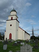
Grue kirke

River Rottnan in Svullrya

Opaker Grue

Løvhaugsåa in Hedmark


References[]
- ^ "(+) Tungt kjede for ny ordfører, men stolen er god å sitte i". www.ostlendingen.no (in Norwegian). 2019-10-08. Retrieved 2019-10-10.
- ^ "Navn på steder og personer: Innbyggjarnamn" (in Norwegian). Språkrådet.
- ^ "Forskrift om målvedtak i kommunar og fylkeskommunar" (in Norwegian). Lovdata.no.
- ^ "Om Grues kommunevåpen" (in Norwegian). Grue Kommune. Archived from the original on 2009-03-22. Retrieved 2008-12-21.
- ^ "Immigrants and Norwegian-born to immigrant parents, by immigration category, country background and percentages of the population". ssb.no. Archived from the original on 2 July 2015. Retrieved 29 June 2015.
External links[]
 Media related to Grue at Wikimedia Commons
 The dictionary definition of Grue at Wiktionary
- Municipal fact sheet from Statistics Norway
| hide | |||||||||||||||||||||
|---|---|---|---|---|---|---|---|---|---|---|---|---|---|---|---|---|---|---|---|---|---|
| |||||||||||||||||||||
 | Towns and cities |
|  | ||||||||||||||||||
| Municipalities |
| ||||||||||||||||||||
| show Authority control |
|---|
- Grue, Norway
- Municipalities of Hedmark
- Forest Finns
- Populated places on the Glomma River