Sør-Odal
Sør-Odal kommune | |
|---|---|
 | |
 Coat of arms  Innlandet within Norway | |
 Sør-Odal within Innlandet | |
| Coordinates: 60°14′12″N 11°44′44″E / 60.23667°N 11.74556°ECoordinates: 60°14′12″N 11°44′44″E / 60.23667°N 11.74556°E | |
| Country | Norway |
| County | Innlandet |
| District | Odal, Norway |
| Administrative centre | Skarnes |
| Government | |
| • Mayor (2016) | Knut Hvithammer (Ap) |
| Area | |
| • Total | 517 km2 (200 sq mi) |
| • Land | 479 km2 (185 sq mi) |
| Area rank | 203 in Norway |
| Population (2016) | |
| • Total | approximately 7,800 |
| • Rank | 129 in Norway |
| • Density | 16/km2 (40/sq mi) |
| • Change (10 years) | 3.4% |
| Demonym(s) | Odøling[1] |
| Time zone | UTC+01:00 (CET) |
| • Summer (DST) | UTC+02:00 (CEST) |
| ISO 3166 code | NO-3415 |
| Official language form | Bokmål[2] |
| Website | www |

Sør-Odal is a municipality in Innlandet county, Norway. It is part of the traditional region of Odalen. The administrative centre of the municipality is the village of Skarnes.
The parish of Søndre Odalen was established as a municipality on 1 January 1838 (see formannskapsdistrikt).
The municipality is a rural community situated along the river Glåma and around the southern side of the lake Storsjøen. It is bordered by the municipalities of Eidskog in the south, by Kongsvinger in the east, and by Nord-Odal and Grue in the north. The terrain is dominated by rolling hills, lakes, and pine forests.
General information[]
Name[]
The last element is the old district name Odal (Old Norse: Ódalr). The first element of this is ó, a sideform of á which means "river" (here the Glåma river). The last element is dalr which means "valley" or "dale".
The first element Sør- (meaning "southern") was added after 1819 when the parish of Odal was divided in two. (See Nord-Odal.)
Coat-of-arms[]
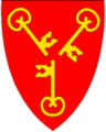
The coat-of-arms is from modern times. They were granted on 10 January 1992. The arms show three gold keys on a red background. They represent the three parishes of Oppstad, Strøm, and Ulleren and the three local bodies of water: Glomma, Oppstadåa, and Storsjøen. The key symbolizes justice, knowledge, and positive ideals. The arms were designed by Harald Hallstensen.[3]
Ethnic and foreign minority[]
| Ancestry | Number |
|---|---|
| 101 | |
| 49 | |
| 46 | |
| 45 | |
| 37 | |
| 37 | |
| 34 | |
| 22 |
Economy[]
The economy is based on a mix of manufacturing, farming, and services. Skarnes has a train connection to Oslo.
Notable residents[]

- Hans Glad Bloch (1791 in Sør-Odal – 1865) a Norwegian military officer and government official
- Peder Sather (1810 in Odal – 1886) American banker and philanthropist, eponymn of the Sather Tower & Sather Gate at UC Berkeley
- Magnhild Haalke (1885–1984) a Norwegian novelist and teacher for 30 years in Sør-Odal
- Kåre Tveter (1922 in Sør-Odal – 2012) a Norwegian painter and illustrator
- Ole A. Stang Jr. (1923 in Sør-Odal – 1998) businessman, owned and ran Maarud AS
- Øystein Sunde (born 1947) folk singer, guitarist and songwriter; brought up in Skarnes
- Martin Linnes (born 1991 in Sander) a footballer with over 240 club caps and 27 for Norway
- Kent Håvard Eriksen (born 1991 in Skarnes) a footballer with over 250 club caps
Sister cities[]
The following cities are twinned with Sør-Odal:[5]
 - Viitasaari, Länsi-Suomi, Finland
Gallery[]

Ulleren kirke

Oppstadåa i Sør-Odal

Sør-Odal

Maarud Airport


References[]
- ^ "Navn på steder og personer: Innbyggjarnamn" (in Norwegian). Språkrådet.
- ^ "Forskrift om målvedtak i kommunar og fylkeskommunar" (in Norwegian). Lovdata.no.
- ^ "Kommunevåpen for Sør-Odal kommmune" (in Norwegian). Sør-Odal kommmune. Retrieved 2008-12-29.
- ^ "Immigrants and Norwegian-born to immigrant parents". ssb.no. Archived from the original on 2 July 2015. Retrieved 29 June 2015.
- ^ "Sør-Odal - en kommune med mangfold i kulturtilbudet" (in Norwegian). Sør-Odal kommune. Retrieved 2008-12-29.
External links[]
 Media related to Sør-Odal at Wikimedia Commons
- Municipal fact sheet from Statistics Norway
| hide | |||||||||||||||||||||
|---|---|---|---|---|---|---|---|---|---|---|---|---|---|---|---|---|---|---|---|---|---|
| |||||||||||||||||||||
 | Towns and cities |
|  | ||||||||||||||||||
| Municipalities |
| ||||||||||||||||||||
| show Historic mines and processing operations of Norway |
|---|

| show Authority control |
|---|
- Sør-Odal
- Municipalities of Hedmark
- 1838 establishments in Norway