Skjåk
Skjåk kommune | |
|---|---|
 | |
 Coat of arms  Innlandet within Norway | |
 Skjåk within Innlandet | |
| Coordinates: 61°56′10″N 7°57′37″E / 61.93611°N 7.96028°ECoordinates: 61°56′10″N 7°57′37″E / 61.93611°N 7.96028°E | |
| Country | Norway |
| County | Innlandet |
| District | Gudbrandsdalen |
| Administrative centre | Bismo |
| Government | |
| • Mayor (2015) | Elias Sperstad (Sp) |
| Area | |
| • Total | 2,076 km2 (802 sq mi) |
| • Land | 1,969 km2 (760 sq mi) |
| Area rank | 27 in Norway |
| Population (2004) | |
| • Total | 2,393 |
| • Rank | 311 in Norway |
| • Density | 1.15/km2 (3.0/sq mi) |
| • Change (10 years) | −5.3% |
| Demonym(s) | Skjåkvær[1] |
| Time zone | UTC+01:00 (CET) |
| • Summer (DST) | UTC+02:00 (CEST) |
| ISO 3166 code | NO-3433 |
| Official language form | Nynorsk[2] |
| Website | www |

Skjåk is a municipality in Innlandet county, Norway. It is part of the traditional region of Gudbrandsdalen. The administrative centre of the municipality is the village of Bismo. The municipality of Skjåk was created when it was separated from Lom to become a municipality of its own in 1866.
The local newspaper is named Fjuken.
General information[]
Name[]
The municipality (originally the parish) is named after the old Skjåk farm (Old Norse: Skeiðakr), since the first church was built here. The first element is skeið which means "a running track for horse racing" and the last element is akr which means "field" or "acre".[3]
Prior to 1889, the name was written "Skiaker", then from 1889-1910 it was spelled "Skiaaker", from 1911-1920 it was "Skjaak", and since 1921 it has been written in its present form, "Skjåk".
Coat-of-arms[]
The coat-of-arms is from modern times. They were granted on 31 March 1989. It shows four silver-colored acanthus leaves on a blue background. This was picked to symbolize growth and strength. These symbols are found in many historic artifacts from around the area.[4]
| Ancestry | Number |
|---|---|
| 40 | |
| 26 | |
| 8 | |
| 3 |
History[]
Skjåk has historical roots back to the Viking Age and has a rich cultural heritage. An ancient route of travel between east and west went from Skjåk up through the Raudal valley and down through the Sunndal valley to Stryn on an arm of the Nordfjord. For example, in 1197, according to King Sverre's saga, Bishop Nikolaus is reported to have sent a group of baglers from Oppdal over the mountains to Stryn on Nordfjord, via Raudal.
Geography[]

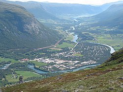
Skjåk is the westernmost municipality in the valley of Ottadalen. It is bordered to the north by the municipality of Norddal, Rauma, and Lesja, in the east and southeast by Lom, in the south by Luster and in the west by Stryn and Stranda. The municipality lies along the Otta river between the mountainous areas of Breheim and Reinheim. Bismo is the modern population center and the location of the majority of industry and shopping as well as the municipal administration.
The community is at the meeting point between Gudbrandsdalen and the mountains between the eastern parts of Norway and the west coast. The municipality lies on a historically significant traffic artery between Stryn and Nordfjord, Geiranger, and Sunnmøre and the more easterly Ottadal municipalities of Lom and Vågå.
Of the total area, 19 square kilometres (7.3 sq mi) is used for agriculture; 129 square kilometres (50 sq mi) for forestry; 75 square kilometres (29 sq mi) is covered by water (including the Breiddalsvatnet lake); and the rest is mountains and other non-arable land. Virtually the entire 23 kilometres (14 mi) long valley floor is continuously, but sparsely, built up. Skjåk serves as a point of entry to the mountain areas just west; hunting and fishing are also popular tourist activities.
Climate[]
Nestled in a deep valley, the populated regions of Skjåk are rain shadowed and as a result are actually one of the most arid places in Europe with annual precipitation of about 250 millimetres (10 in) per year, but it avoids a steppe climate (Köppen Bsk) by being too cold (mean annual temperature of 2.75 °C [36.95 °F]), thus having a low evapotranspiration rate, and having precipitation too spread out (ca 55% in summer). This gives Skjåk a rare dry-summer subarctic climate (Köppen Dsc), thanks to low overall precipitation levels in summer.[6][7]
In addition, one side of the valley, solsida ("the sunny side"), has a southern exposure, whereas baksida (the "back side") gets very little sun. Agriculture has been enabled by elaborate irrigation systems for hundreds of years, so the area is green and productive rather than desert-like.
| hideClimate data for Skjåk, Oppland (1961-1990) 372m asl, Norway | |||||||||||||
|---|---|---|---|---|---|---|---|---|---|---|---|---|---|
| Month | Jan | Feb | Mar | Apr | May | Jun | Jul | Aug | Sep | Oct | Nov | Dec | Year |
| Daily mean °C (°F) | −9.4 (15.1) |
−8.2 (17.2) |
−2.7 (27.1) |
2.7 (36.9) |
8.5 (47.3) |
12.7 (54.9) |
13.9 (57.0) |
12.8 (55.0) |
8.4 (47.1) |
3.8 (38.8) |
−2.9 (26.8) |
−6.6 (20.1) |
2.8 (36.9) |
| Average precipitation mm (inches) | 20 (0.8) |
12 (0.5) |
12 (0.5) |
5 (0.2) |
15 (0.6) |
28 (1.1) |
43 (1.7) |
35 (1.4) |
30 (1.2) |
32 (1.3) |
23 (0.9) |
24 (0.9) |
279 (11.1) |
| Source: Meteorologisk institutt[6] | |||||||||||||
Notable residents[]
- Skjåk-Ola, (Norwegian Wiki) (1744 in Skjåk - 1803) real name Ola Rasmussen Skjåk, wood carver
- Tore Ørjasæter (1886 in Skjåk – 1968) an educator, literature critic, author and poet
- Jan-Magnus Bruheim (1914 in Skjåk – 1988) a Norwegian poet and children's writer
- Magnhild Bruheim, (Norwegian Wiki) (born 1951 in Skjåk) author and journalist
- Rune Øygard (born 1959 in Skjåk) a former politician and convicted paedophile
- Trond Bersu (born 1984 in Skjåk) a Norwegian drummer and producer
References[]
- ^ "Navn på steder og personer: Innbyggjarnamn" (in Norwegian). Språkrådet.
- ^ "Forskrift om målvedtak i kommunar og fylkeskommunar" (in Norwegian). Lovdata.no.
- ^ Rygh, Oluf (1900). Norske gaardnavne: Kristians amt (in Norwegian) (4 ed.). Kristiania, Norge: W. C. Fabritius & sønners bogtrikkeri. pp. 30 & 33.
- ^ "Kommunevåpenet" (in Norwegian). Skjåk kommune. Archived from the original on 2007-09-21. Retrieved 2009-01-03.
- ^ "Immigrants and Norwegian-born to immigrant parents, by immigration category, country background and percentages of the population". ssb.no. Archived from the original on 2 July 2015. Retrieved 29 June 2015.
- ^ Jump up to: a b "Meteorologisk institutt". Archived from the original on 2016-11-19.
- ^ "Koppen climate calculator". Archived from the original on 2016-11-19.
External links[]
| Wikimedia Commons has media related to Skjåk. |
| Look up Skjåk in Wiktionary, the free dictionary. |
- Municipal fact sheet from Statistics Norway
 Oppland travel guide from Wikivoyage
- Gudbrandsdalen travel guide from Wikivoyage
| hide | |||||||||||||||||||||
|---|---|---|---|---|---|---|---|---|---|---|---|---|---|---|---|---|---|---|---|---|---|
| |||||||||||||||||||||
 | Towns and cities |
|  | ||||||||||||||||||
| Municipalities |
| ||||||||||||||||||||
| Authority control |
|
|---|
- Skjåk
- Municipalities of Oppland