Rendalen
Rendalen kommune | |
|---|---|
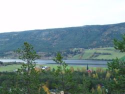 Otnes village and Lomnessjøen | |
 Coat of arms  Innlandet within Norway | |
 Rendalen within Innlandet | |
| Coordinates: 61°51′34″N 11°10′34″E / 61.85944°N 11.17611°ECoordinates: 61°51′34″N 11°10′34″E / 61.85944°N 11.17611°E | |
| Country | Norway |
| County | Innlandet |
| District | Østerdalen |
| Administrative centre | Bergset |
| Government | |
| • Mayor (2007) | Norvald Illevold (Ap) |
| Area | |
| • Total | 3,180 km2 (1,230 sq mi) |
| • Land | 3,061 km2 (1,182 sq mi) |
| Area rank | 11 in Norway |
| Population (2004) | |
| • Total | 2,146 |
| • Rank | 332 in Norway |
| • Density | 0.7/km2 (2/sq mi) |
| • Change (10 years) | −11.8% |
| Demonym(s) | Rendøl[1] |
| Time zone | UTC+01:00 (CET) |
| • Summer (DST) | UTC+02:00 (CEST) |
| ISO 3166 code | NO-3424 |
| Official language form | Bokmål[2] |
| Website | www |

Rendalen is a municipality in Innlandet county, Norway. It is part of the traditional region of Østerdalen. The administrative centre of the municipality is the village of Bergset.
General information[]
Name[]
The Old Norse form of the name was Reindalr. The first element is the rein old Norsk for reindeer and the last element is dal which means "valley" or "dale". The meaning of the river name is from the valley or vice versa. Renafjellet is one of the other mountains.
Coat-of-arms[]
The coat-of-arms is from modern times. They were granted on 2 June 1989. The arms show two silver reindeer on a blue background. They symbolize the importance of reindeer farming in the community. The two heads represent the two former municipalities of Øvre Rendal and Ytre Rendal. The arms were designed by the artist Arvid Sveen.[3][4]
History[]
The municipality of Rendalen was established on 1 January 1838 (see formannskapsdistrikt). Rendalen was divided into two separate municipalities (Ytre Rendal and Øvre Rendal) in 1880 when there was a population of 3,529. The two municipalities were reunited on 1 January 1965 and took the name Rendalen.
Geography[]
Rendalen is bordered on the northwest by the municipalities of Alvdal and Tynset, in the north by Tolga, in the east by Engerdal, in the south by Trysil and Åmot, and in the west by Stor-Elvdal.
Rendalen municipality encompasses most of the Rendalen valley, a side valley of the Østerdalen. In addition, the municipality encompasses the northern part of Storsjø, a mountainous area in the east of Rendalen and a small part of Østerdalen itself. It also comprises lake Sølensjøen.
The municipality has an area of 3,180 square kilometres (1,227.8 sq mi) which makes it the largest in southern Norway. The highest mountain is Sølen (Midtre) at 1,755 metres (5,758 ft)
Economy[]
The primary occupations are in farming and logging, but tourism is also important. The Renåfjellet mountain area provides for excellent alpine hiking.
Notable residents[]

- Johan Reinhardt (1778 in Rendalen – 1845) professor of zoology at Copenhagen University
- Gustav Storm (1845 in Rendalen – 1903) a Norwegian historian and academic
- Jacob Breda Bull (1853 in Rendalen – 1930) a Norwegian author, journalist and editor
- David P. Kvile (1861–1918) a teacher, farmer and politician; teacher in Øvre Rendal from 1885
- Peder E. Vorum (1884–1970) an educator and politician, Mayor of Ytre Rendal from 1913 to 1934; joined Nasjonal Samling 1940, collaborated in WWII, convicted of treason in 1948[5]
- Ottar E. Akre (1896 in Ytre Rendal – 1992) a Norwegian accordionist, composer, and educator
- Sigurd Akre-Aas (1897 in Ytre Rendal – 1968) a Norwegian fencer, competed at the 1924 and 1928 Summer Olympics
- Oddbjørn Hagen (1908 in Ytre Rendal – 1983) a Norwegian skier, at the 1936 Winter Olympics he won one gold in the Nordic combined and two silvers in cross-country skiing
- Kjell Borgen (1939–1996) politician, former Minister of Transport, secondary school teacher in Rendalen, 1962 to 1966
- Ola Otnes (born 1951 in Rendalen) a Norwegian actor [6]
- Guren Hagen, (Norwegian Wiki) (born 1959 in Rendalen) musician
International relations[]
Twin towns – Sister cities[]
Rendalen is twinned with:[7]
 - Aalborg, Region Nordjylland, Denmark[8]
 - Liperi, Itä-Suomi, Finland
 - Orsa, Dalarna County, Sweden
Gallery[]

Hanestadnea kraftverk
Øvre Rendal

Rendalen kraftverk


References[]
- ^ "Navn på steder og personer: Innbyggjarnamn" (in Norwegian). Språkrådet.
- ^ "Forskrift om målvedtak i kommunar og fylkeskommunar" (in Norwegian). Lovdata.no.
- ^ Norske Kommunevåpen (1990). "Nye kommunevåbener i Norden". Retrieved 2008-12-29.
- ^ "Rendalens Kommunevåpen" (Microsoft Word) (in Norwegian). Rendalen kommune. Retrieved 2008-12-29.
- ^ "Peder Edvard Vorum" (in Norwegian). Norwegian Social Science Data Services (NSD). Retrieved 23 October 2010.
- ^ IMDb Database retrieved 24 August 2020
- ^ "Besøk fra vennskapskommuner" (in Norwegian). Rendalen kommune. Archived from the original on 2006-09-07. Retrieved 2008-12-29.
- ^ "Aalborg Twin Towns". Europeprize.net. Archived from the original on 7 September 2013. Retrieved 19 August 2013.
External links[]
| Wikimedia Commons has media related to Rendalen. |
| Look up Rendalen in Wiktionary, the free dictionary. |
- Municipal fact sheet from Statistics Norway
- Municipal website (in Norwegian)
| hide | |||||||||||||||||||||
|---|---|---|---|---|---|---|---|---|---|---|---|---|---|---|---|---|---|---|---|---|---|
| |||||||||||||||||||||
 | Towns and cities |
|  | ||||||||||||||||||
| Municipalities |
| ||||||||||||||||||||
| show Authority control |
|---|
- Rendalen
- Municipalities of Innlandet
- Valleys of Innlandet