Søndre Land
Søndre Land kommune | |
|---|---|
 | |
 Coat of arms  Innlandet within Norway | |
 Søndre Land within Innlandet | |
| Coordinates: 60°40′37″N 10°16′44″E / 60.67694°N 10.27889°ECoordinates: 60°40′37″N 10°16′44″E / 60.67694°N 10.27889°E | |
| Country | Norway |
| County | Innlandet |
| District | Land, Norway |
| Administrative centre | Hov |
| Government | |
| • Mayor (2003) | Reidar Eriksen (Søndre Land Bygdeliste) |
| Area | |
| • Total | 728 km2 (281 sq mi) |
| • Land | 659 km2 (254 sq mi) |
| Area rank | 150 in Norway |
| Population (2004) | |
| • Total | 6,042 |
| • Rank | 165 in Norway |
| • Density | 9/km2 (20/sq mi) |
| • Change (10 years) | −3.7% |
| Demonym(s) | Søndrelending[1] |
| Time zone | UTC+01:00 (CET) |
| • Summer (DST) | UTC+02:00 (CEST) |
| ISO 3166 code | NO-3447 |
| Official language form | Bokmål[2] |
| Website | www |

Søndre Land is a municipality in Innlandet county, Norway. It is part of the traditional region of Land. The administrative centre of the municipality is the village of Hov.
The old municipality of Land was divided into Søndre Land and Nordre Land in 1847. The area of Fluberg was separated from Søndre Land to become a separate municipality on 1 January 1914, but it was merged back into Søndre Land on 1 January 1962.
General information[]
Name[]
The Old Norse form of the name was just Land which means "land". Therefore, the meaning of the name Søndre Land is "(the) southern (part of) Land". The parish and municipality of Land was divided in 1847.[3]
Coat-of-arms[]
The coat-of-arms is from modern times. They were granted on 21 June 1985. The arms show three yellow tree trunks on a blue background. The blue colour of the shield symbolises the Randsfjorden, which borders the municipality. The tree trunks symbolise the importance of forestry and the sawmills in the municipality.[4]
| Ancestry | Number |
|---|---|
| 77 | |
| 57 | |
| 36 | |
| 32 | |
| 24 | |
| 22 | |
| 18 |
Geography[]
Søndre Land is bordered on the north by the municipality of Nordre Land, on the east by Gjøvik and Vestre Toten, on the west by Sør-Aurdal, and on the south by Gran in Oppland county. It is also bordered to the west by Ringerike in Buskerud county.
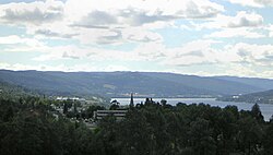
Søndre Land is 39.2 kilometres (24.4 mi) on a north–south axis and 31.3 kilometres (19.4 mi) east-west. It lies in the south of Oppland and on the northern end of Randsfjord. The highest elevation is Skjellinghovde with a height of 856 metres (2,808 ft). The main population centers include Holmen and Hov.
Notable residents[]

- Christian Ancher (1711-1765) a Norwegian merchant, timber trader and ship owner
- Peder Aadnes (1739–1792) a Norwegian rural painter
- Jørgen Meinich (1820-1911) a Norwegian jurist and wood processor
- Martin Smeby (1891-1975), politician, Mayor of Søndre Land in 1930's
- Ola Viker (1897-1942) a Norwegian novelist and lawyer
- Håvard Narum (born 1944) a Norwegian journalist and author.
- Ola Skjølaas (1941-2006) a Norwegian veterinarian, civil servant and politician
- Per Blom (1946-2013) a Norwegian film director [6]
- Finn Thrana (1958–2006) a Norwegian barrister and civil servant for Nasjonal Samling
- Ellen Andrea Wang (born 1986) a Norwegian jazz double bass player, singer and composer
Gallery[]

Hov Kirke Church (1781), Søndre Land Municipality

Fluberg bru

Landåsbygda og Landåsvannet en høstdag


References[]
- ^ "Navn på steder og personer: Innbyggjarnamn" (in Norwegian). Språkrådet.
- ^ "Forskrift om målvedtak i kommunar og fylkeskommunar" (in Norwegian). Lovdata.no.
- ^ Rygh, Oluf (1900). Norske gaardnavne: Kristians amt (Anden halvdel) (in Norwegian) (4 ed.). Kristiania, Norge: W. C. Fabritius & sønners bogtrikkeri. p. 179.
- ^ Norske Kommunevåpen (1990). "Nye kommunevåbener i Norden". Retrieved 2009-01-01.
- ^ "Immigrants and Norwegian-born to immigrant parents, by immigration category, country background and percentages of the population". ssb.no. Archived from the original on 2 July 2015. Retrieved 29 June 2015.
- ^ IMDb Database retrieved 25 December 2020
External links[]
 Media related to Søndre Land at Wikimedia Commons
 The dictionary definition of Søndre Land at Wiktionary
- Municipal fact sheet from Statistics Norway
 Oppland travel guide from Wikivoyage
| hide | |||||||||||||||||||||
|---|---|---|---|---|---|---|---|---|---|---|---|---|---|---|---|---|---|---|---|---|---|
| |||||||||||||||||||||
 | Towns and cities |
|  | ||||||||||||||||||
| Municipalities |
| ||||||||||||||||||||
| Authority control |
|
|---|
- Søndre Land
- Municipalities of Oppland
- Land, Norway