Felsőregmec
Felsőregmec | |
|---|---|
 Seal | |
 Felsőregmec Location of Felsőregmec | |
| Coordinates: 48°29′30″N 21°36′16″E / 48.49171°N 21.60432°ECoordinates: 48°29′30″N 21°36′16″E / 48.49171°N 21.60432°E | |
| Country | |
| County | Borsod-Abaúj-Zemplén |
| Area | |
| • Total | 10.75 km2 (4.15 sq mi) |
| Population (2004) | |
| • Total | 271 |
| • Density | 25.2/km2 (65/sq mi) |
| Time zone | UTC+1 (CET) |
| • Summer (DST) | UTC+2 (CEST) |
| Postal code | 3989 |
| Area code(s) | 47 |

Felsőregmec (Slovak: Vyšný Redmec) is a village in the Borsod-Abaúj-Zemplén county in northeastern Hungary.
External links[]
- Street map (in Hungarian)
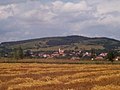
A view of Felsoregmec from the south

The 13th/14th century Reformed Church
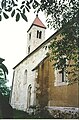
View of the church from the SE


This Borsod-Abaúj-Zemplén location article is a stub. You can help Wikipedia by . |
Categories:
- Populated places in Borsod-Abaúj-Zemplén County
- Romanesque architecture in Hungary
- Borsod-Abaúj-Zemplén geography stubs