Mályinka
show This article may be expanded with text translated from the corresponding article in Hungarian. (December 2009) Click [show] for important translation instructions. |
Mályinka | |
|---|---|
Village | |
 | |
 Flag  Coat of arms | |
 Mályinka Location of Mályinka | |
| Coordinates: 48°09′24″N 20°29′40″E / 48.15668°N 20.49441°ECoordinates: 48°09′24″N 20°29′40″E / 48.15668°N 20.49441°E | |
| Country | Hungary |
| Region | Northern Hungary |
| County | Borsod-Abaúj-Zemplén |
| District | Kazincbarcika |
| Area | |
| • Total | 24.2 km2 (9.3 sq mi) |
| Population (1 January 2015)[1] | |
| • Total | 447 |
| • Density | 18/km2 (48/sq mi) |
| Time zone | UTC+1 (CET) |
| • Summer (DST) | UTC+2 (CEST) |
| Postal code | 3645 |
| Area code | (+36) 48 |
| Website | www |

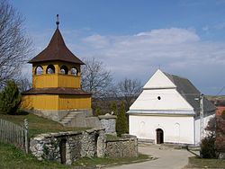
Mályinka is a village in Borsod-Abaúj-Zemplén County in northeastern Hungary.[2] Has road connection to the near Dédestapolcsány, Tardona, Nagyvisnyó. The closest town is Kazincbarcika.
Mályinka is located on the north side of Bükk Mountains. Because of the picturesque landscape the village is on the path of the National Blue Trail.
References[]
- ^ "Gazetteer of Hungary, 1st January 2015" (in Hungarian). Hungarian Central Statistical Office. 3 September 2015. Retrieved 4 September 2015.
- ^ Központi Statisztikai Hivatal (KSH) (in Hungarian)


| show Authority control |
|---|
This Borsod-Abaúj-Zemplén location article is a stub. You can help Wikipedia by . |
Categories:
- Populated places in Borsod-Abaúj-Zemplén County
- Borsod-Abaúj-Zemplén geography stubs