Telkibánya
Telkibánya | |
|---|---|
Village | |
 Aerial photography of Telkibánya | |
 Flag  Coat of arms | |
 Telkibánya Location of Telkibánya in Hungary | |
| Coordinates: 48°28′58″N 21°21′24″E / 48.4829°N 21.3566°ECoordinates: 48°28′58″N 21°21′24″E / 48.4829°N 21.3566°E | |
| Country | Hungary |
| Region | Northern Hungary |
| County | Borsod-Abaúj-Zemplén |
| Government | |
| • Mayor | Lászlóné Mester |
| Area | |
| • Total | 46.82 km2 (18.08 sq mi) |
| Population (2015)[2] | |
| • Total | 549 |
| • Density | 12/km2 (30/sq mi) |
| Time zone | UTC+1 (CET) |
| • Summer (DST) | UTC+2 (CEST) |
| Postal code | 3896 |
| Area code | +36 46 |
| Website | https://telkibanya.hu/ |

Telkibánya is a village in Borsod-Abaúj-Zemplén county, in the Northern Hungary region of northeastern Hungary.
Geography[]
It covers an area of 46.82 km2 (18 sq mi) and has a population of 549 people (2015).[2]
Main Sights[]
- Protestant cemetery and church
- St. Catherine zion
- Mining Museum
- Ruins of Koncfalva
- Ice cave
- Mining pits and former gold washing claims
- Surface minerals
- Surface perlite flow
Gallery[]
- Photos of Telkibánya

Protestant cemetery

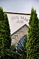
Protestant church

runes and St. Catherine zion

Altar of St. Catherine painted by Zoltán Joó

Cemetery at the Protestant church
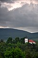
Protestant church from the Bizsóka
Unitarist church front


References[]
- ^ Telkibánya at the Hungarian Central Statistical Office (Hungarian).
- ^ Jump up to: a b Gazetteer of Hungary, 1st January 2015. Hungarian Central Statistical Office. 3 September 2015
External links[]
| Wikimedia Commons has media related to Telkibánya. |


| show Authority control |
|---|
This Borsod-Abaúj-Zemplén location article is a stub. You can help Wikipedia by . |
Categories:
- Borsod-Abaúj-Zemplén geography stubs
- Populated places in Borsod-Abaúj-Zemplén County