Flores da Cunha
This article needs additional citations for verification. (October 2014) |
Flores da Cunha | |
|---|---|
 | |
 Flag  Seal | |
| Nickname(s): Terra do Galo (The land of the Rooster) | |
 Flores da Cunha Location in Brazil | |
| Coordinates: 29°01′50″S 51°11′00″W / 29.03056°S 51.18333°WCoordinates: 29°01′50″S 51°11′00″W / 29.03056°S 51.18333°W | |
| Country | Brazil |
| Region | South |
| State | State of Rio Grande do Sul |
| Founded | May 17, 1924 |
| Government | |
| • Mayor | Lidio Scortegagna (PMDB) |
| Area | |
| • Total | 272,662 km2 (105,275 sq mi) |
| Elevation | 756 m (2,480 ft) |
| Population (2020 [1]) | |
| • Total | 31,063 |
| • Density | 99.2/km2 (257/sq mi) |
| Time zone | UTC-3 (UTC-3) |
| • Summer (DST) | UTC-2 (UTC-2) |
| Website | Flores da Cunha City Hall |

Location of Flores da Cunha in the state of Rio Grande do Sul
Flores da Cunha is a municipality in the state of Rio Grande do Sul, Brazil. It is the largest producer of wines inside Brazil. The Venetian language in its Brazilian form Talian is co-official with Portuguese in Flores da Cunha.
Climate[]
Because of the Altitude of 756 meters above the sea level, The Climate of Flores da Cunha is Oceanic Climate type Cfb. With warm (not hot) to cool summers with some few experiences of snowfall between July and August.
| Flores da Cunha | ||||||||||||||||||||||||||||||||||||||||||||||||||||||||||||
|---|---|---|---|---|---|---|---|---|---|---|---|---|---|---|---|---|---|---|---|---|---|---|---|---|---|---|---|---|---|---|---|---|---|---|---|---|---|---|---|---|---|---|---|---|---|---|---|---|---|---|---|---|---|---|---|---|---|---|---|---|
| Climate chart (explanation) | ||||||||||||||||||||||||||||||||||||||||||||||||||||||||||||
| ||||||||||||||||||||||||||||||||||||||||||||||||||||||||||||
| ||||||||||||||||||||||||||||||||||||||||||||||||||||||||||||
Gallery[]

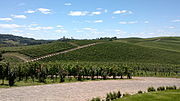
Luiz Argenta Winery, the largest winery in the City
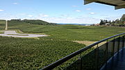
Luiz Argenta

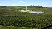
Luiz Argenta

Luiz Argenta
Luiz Argenta
Luiz Argenta

Luiz Argenta

Luiz Argenta
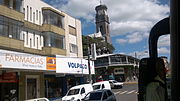
Flores da Cunha Downtown
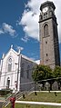
A church at Flores da Cunha Town


See also[]
- List of municipalities in Rio Grande do Sul
References[]
| show |
|---|

| show Authority control |
|---|
 | This geographical article relating to Rio Grande do Sul is a stub. You can help Wikipedia by . |
Categories:
- Municipalities in Rio Grande do Sul
- Rio Grande do Sul geography stubs