Gordon, New South Wales
| Gordon Sydney, New South Wales | |||||||||||||||
|---|---|---|---|---|---|---|---|---|---|---|---|---|---|---|---|
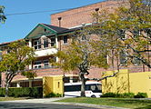
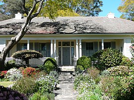 Eryldene, a heritage-listed home built circa 1913 | |||||||||||||||
 | |||||||||||||||
| Population | 7,668 (2016 census)[1] | ||||||||||||||
| • Density | 2,023.2/km2 (5,240/sq mi) | ||||||||||||||
| Established | 1823 | ||||||||||||||
| Postcode(s) | 2072 | ||||||||||||||
| Area | 3.79 km2 (1.5 sq mi) | ||||||||||||||
| Location | 14 km (9 mi) north-west of Sydney CBD | ||||||||||||||
| LGA(s) | Ku-ring-gai Council | ||||||||||||||
| State electorate(s) | Ku-ring-gai, Davidson | ||||||||||||||
| Federal division(s) | Bradfield | ||||||||||||||
| |||||||||||||||
Gordon is a suburb on the Upper North Shore of Sydney in the state of New South Wales, Australia 14 kilometres (9 mi) north-west of the Sydney Central Business District and is the administrative centre for the local government area of Ku-ring-gai Council. East Gordon is a locality within Gordon, and West Gordon is a locality within West Pymble.[2]
History[]
The name 'Gordon' first appears as the name of the survey parish covering most of the upper north shore, assigned by the NSW Surveyor-General Sir Thomas Mitchell. This is believed to commemorate Sir Willoughby Gordon, with whom he had served during the Peninsular War and who was the quartermaster-general of the regiment in which Mitchell had served. The survey parish, and later suburb and municipality of Willoughby also commemorates his name.[3]
Settlement of the area commenced about 1820. The early settlement at Gordon was originally known as Lane Cove. The earliest school at 'Lane Cove', as Gordon was then known, was established at the behest of Governor Macquarie in 1816.[3] The first Lane Cove Post Office opened on 1 February 1860. The name of the village and Post Office was changed to Gordon, after the Gordondale estate of Robert McIntosh, on 1 June 1879.[3][4] Gordon Railway Station on the North Shore Line was built in 1888.
In the late 20th century Gordon was the Australian headquarters of Sun Microsystems Australia (opposite the present Gordon library site). It also had a significant Ikea store on the corner of the Pacific Highway and Ryde Road (opposite the former 3M site on the northern or Pymble side of the intersection, circa 2014-2020 under legally frustrated intent to renovate for use by Bunnings[5][6]).
Gordon Public School[]
The former Gordon Public School, now largely demolished and rebuilt as the library and police station, was constructed in 1878 on the Pacific Highway, having been designed by George Mansfield. A Gothic Revival style was used in accordance with the tradition that educational buildings, like churches, were designed in a Gothic style. A second block was added in 1912. The school was originally called Lane Cove School, and the name was officially changed to Gordon Public School in November 1885.[3] The school buildings are one of the few remaining buildings that date back to the pioneering days of northern Sydney. It is listed on the Register of the National Estate.[7] The Gordon Public School was closed in 1989, however East Gordon Public School and West Gordon Public School remain nearby.
Heritage listings[]
Gordon has a number of heritage-listed sites, including:
- 17 McIntosh Street: Eryldene, Gordon[8]
- Middlemiss Street: Gordon railway station, Sydney[9]
- 691 Pacific Highway: Iolanthe, Gordon[10]
- 707 Pacific Highway: Tulkiyan[11]
- 799 Pacific Highway: Gordon Public School (former)[12]
In addition, Gordon is home to Sydney's largest flying fox colony, land for the protection of which was jointly purchased by the Heritage Council of New South Wales and Kuringai Council.[13]
Notable former residents[]
- Dr John Bradfield, chief engineer of the Sydney Harbour Bridge, lived in Gordon where his grave is located at St Johns Anglican Church.
- Annie Wyatt was the founder of the National Trust in Australia. She lived for a time in a single-storey cottage in Park Avenue.
- Craig Steven Wright, self-styled Bitcoin creator, who lived with his wife Ramona at 43 St. Johns Avenue[14]
- Greg Dwyer, first employee at BitMEX[15]
Transport[]
Gordon is located on a major transport artery, the Pacific Highway and near the intersection of Ryde and Mona Vale Roads which form a link between the northern beaches, Homebush Bay and the St George District and Sutherland Shire.
Gordon railway station is on the North Shore & Western Line of the Sydney Trains network with frequent commuter services and express rail services during peak hours. The railway station was built in 1888 and has an important heritage relationship with its landscaped gardens - it has been preserved as an example of a historic Edwardian station. Lifts to the platforms have been recently added. A bus stop outside the station is a terminus for various routes including those to St Ives, West Pymble, Mona Vale/Warriewood and Macquarie University. These are operated by Forest Coach Lines.
Churches[]
Churches in Gordon comprise: St Johns Anglican Church (with an adjoining cemetery and columbarium), Gordon Uniting Church, Gordon Baptist Church and The Liberal Catholic Church of St. Francis.
Education[]
Gordon is home to two schools:
- Gordon East Public School (K-6)
- Ravenswood School for Girls (K-12)
Gordon West Public School is named after the suburb, but is located in West Pymble.
Gordon Community Preschool supports children from 3 – 5 years of age.
Commercial[]
Gordon has a commercial area with many shops and restaurants along the Pacific Highway and around Gordon railway station. Gordon Centre, is a shopping centre owned by which includes a Harvey Norman, Woolworths and many stores and offices. Gordon Centre was originally built as a Farmers & Co department store, now part of Myer, before reopening as Gordon Centre in 1985. Household hardware chain Bunnings Warehouse and McDonald's is located near the Pacific Highway. Gordon Village Arcade is a shopping arcade also owned by Charter Hall and includes many stores including a post office. Gordon Private Hospital located on the Pacific Highway specialises in the treatment of mental health and is a teaching hospital affiliated with UNSW.
The administrative buildings for the local government area of Ku-ring-gai Council are located in Gordon.
Residential[]
Eryldene is a local historic house that is open to the public. Located in McIntosh Street, the house was designed for Professor Eben Gowrie Waterhouse by William Hardy Wilson and built circa 1913. The extensive garden is a significant part of the property in its own right. House and garden as a whole are listed on the Register of the National Estate.[16][17] The house also has a state heritage listing.[18]
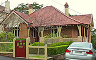
Another notable home in the area is Tulkiyan, located on the Pacific Highway. This home was designed by Bertrand James Waterhouse, an architect who was popular for his residential work (he was also responsible for the design of Nutcote, the home of painter May Gibbs). He designed Tulkiyan in the Arts and Crafts style that he favoured in much of his work. Tulkiyan was built on part of a land grant that went back to 1823. The land changed hands many times until it was acquired by the Donaldson family, who commissioned Waterhouse to design the house. It stayed in the hands of the Donaldson family until 1994, when it was bequeathed to Ku-ring-gai Council. Tulkiyan has a state heritage listing.[19]
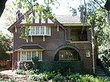
The Arts and Crafts style favoured by Waterhouse was just one of the styles that were part of the Federation period that went from 1890 to 1915. Other prominent styles were the Federation Queen Anne style—the Australian version of the English Queen Anne style—and the Federation Bungalow style. Some notable examples of the latter style can be seen in Nelson Street, Gordon. Other architects who favoured Federation styles were Walter Liberty Vernon and Howard Joseland.
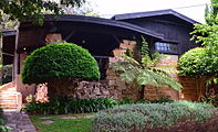
Gordon is also the location of a notable house designed by the architect Alexander Stewart Jolly. Nebraska, in Yarabah Avenue, is a distinctive home reminiscent of a log cabin. One of its features is the irregular stonework. It is heritage-listed.[20]
56.6% of occupied private dwellings in Gordon are separate houses, 39.3% are flats, units or apartments and 4.0% are semi-detached (mainly townhouses). The average household consists of 2.9 people.[1]
Population[]
At the 2016 census, there were 7,668 residents in Gordon.
- The population of Gordon was older than average, with a median age of 40 compared to the national median of 38, and 15.9% of people aged 65 years and over.
- 48.1% of people were born in Australia. The most common countries of birth were China 11.0%, South Korea 5.2%, England 4.5%, Hong Kong 3.7% and Taiwan 2.6%.
- 56.0% of people only spoke English at home. Other languages spoken at home included Mandarin 15.1%, Cantonese 7.4%, Korean 6.0%, Japanese 1.5% and Persian 1.4%.
- The median household income of $2,313 was higher than the national figure of $1,438.
- Housing is expensive in Gordon, with the median weekly rent being $650 and the median monthly mortgage payment being $2,800.
- The most popular responses to the Census question about religion were No Religion 36.4%, Anglican 15.0% and Catholic 14.5%.[1]
Gallery[]

Home of Annie Wyatt, Park Avenue
Federation house, Nelson Street

Federation bungalow, Nelson Street
Tulkiyan, designed by B.J.Waterhouse
Nebraska, designed by Alexander Stewart Jolly

Anglican Church of St John the Evangelist

Cemetery adjoining Anglican Church of St John the Evangelist
Ravenswood School
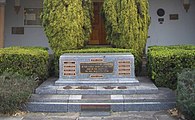
War Memorial and Council Chambers


References[]
| Wikimedia Commons has media related to Gordon, New South Wales. |
- ^ a b c Australian Bureau of Statistics (27 June 2017). "Gordon (State Suburb)". 2016 Census QuickStats. Retrieved 3 September 2017.

- ^ Gregory's Sydney Street Directory, Gregory's Publishing Company, 2007
- ^ a b c d http://www.khs.org.au/local/gordon.html
- ^ Phoenix Auctions History. "Post Office List". Phoenix Auctions. Retrieved 27 January 2021.
- ^ "Court Rejects Challenge to Amber Light Approval".
- ^ "Bunnings Retail Plans in Pymble on Hold as Building Becomes Heritage Listed". 20 November 2014.
- ^ The Heritage of Australia, Macmillan Company, 1981, p.2/33
- ^ "Eryldene". New South Wales State Heritage Register. Office of Environment and Heritage. H00019. Retrieved 18 May 2018.
- ^ "Gordon Railway Station". New South Wales State Heritage Register. Office of Environment and Heritage. H01150. Retrieved 18 May 2018.
- ^ "Iolanthe". New South Wales State Heritage Register. Office of Environment and Heritage. H00227. Retrieved 18 May 2018.
- ^ "Tulkiyan". New South Wales State Heritage Register. Office of Environment and Heritage. H01733. Retrieved 18 May 2018.
- ^ "Gordon Public School". New South Wales State Heritage Register. Office of Environment and Heritage. H00757. Retrieved 18 May 2018.
- ^ "Gordon". Dictionary of Sydney.
- ^ "The Creator of Bitcoin Comes Clean Only to Disappear Again". 10 October 2017.
- ^ Sarah Danckert (17 July 2021). "Aussie crypto mogul fights extradition to the US". Sydney Morning Herald.
- ^ The Heritage of Australia, p.2/33
- ^ "The Eryldene Trust". Collections Australia Network. Commonwealth of Australia. 2008. Retrieved 7 September 2009.
- ^ State Heritage Website
- ^ State Heritage Website
- ^ State Heritage Website
External links[]
- Erydene Historic House and Gardens - official trust website
- Gordon, Ku-ring-gai Council - community profile
- Zeny Edwards and Joan Rowland (2008). "Gordon". Dictionary of Sydney. Retrieved 27 September 2015. [CC-By-SA]
- Zeny Edwards and Joan Rowland (2008). "Killarney Castle". Dictionary of Sydney. Dictionary of Sydney Trust. Retrieved 16 October 2015.[CC-By-SA]
- St Johns Cemetery, Gordon. History of the cemetery and list of burials. Accessed 4 October 2019.
Coordinates: 33°45′26″S 151°08′57″E / 33.75732°S 151.14916°E

- Gordon, New South Wales
- Suburbs of Sydney
- 1823 establishments in Australia
- Populated places established in 1823