Hargeisa
Hargeisa
| |
|---|---|
      | |
 Flag Local council seal of Hargeisa | |
 Interactive map outlining Hargeisa | |
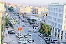
 Hargeisa Location in Somaliland | |
| Coordinates: 9°33′47″N 44°4′3″E / 9.56306°N 44.06750°ECoordinates: 9°33′47″N 44°4′3″E / 9.56306°N 44.06750°E | |
| Country | |
| Region | Maroodi Jeex |
| District | Hargeisa |
| Government | |
| • Mayor | Abdikarim Ahmed Mooge[1][2] |
| Area | |
| • Total | 78 km2 (30 sq mi) |
| Elevation | 1,334 m (4,377 ft) |
| Population (2019)[3] | |
| • Total | 1,200,000 |
| • Density | 1,600/km2 (3,000/sq mi) |
| Demonym(s) | Hargeisan; Hargeysawi |
| Time zone | UTC+3 (EAT) |
| Area code(s) | +252 |


Hargeisa (hər-GAE-sa; Somali: Hargeysa, Arabic: هرجيسا)[4][5] is the capital and largest city of Somaliland. It is located in the Maroodi Jeex region of the Horn of Africa.[6] It succeeded Berbera as the capital of the British Somaliland Protectorate in 1941. The city also served as the second capital of the Isaaq Sultanate during the mid-to-late 19th century.
Hargeisa was founded as a watering and trading stop between the coast and the interior and later became an Islamic Tariqa settlement under the leadership of Sheikh Madar and his mullahs. The city later succeeded Berbera as the capital of the British Somaliland Protectorate in 1941. In 1960, the protectorate gained independence and united as scheduled days later with the Trust Territory of Somaliland (former Italian Somaliland) to form the Somali Republic on July 1.[7]
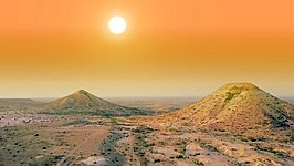
Hargeisa is situated in a valley in the Galgodon (Ogo) highlands, and sits at an elevation of 1,334 m (4,377 ft). Home to rock art from the Neolithic period, the city is also a commercial hub for precious stone-cutting, construction, retail services and trading, among other activities.[4]
Etymology[]
The town evolved in the latter half of the 1800s as a Qadiriyya settlement established by Sheikh Madar, near a water-stop used by nomadic stock-herders on the way to the town of Harar. It proposes a possible derivation of the name "Hargeisa" from the sobriquet Harar as-sagir, meaning "Harar the little"[8][9] According to historian Norman Bennett, Madar named the settlement Hargeisa or Little Harar since he aspired for it to emulate the city of Harar as a center for Islamic teachings.[10] Another etymological root for Hargeisa's name derives from the towns connection to the skins trade. Hargeisa has been a watering and trading stop between the coast and the interior, and chief amongst the goods traded were the hide skins procured from the interior to be processed in the settlement. In this etymological version, ‘Hargeisa’ is derived from hargageys, which means "place to sell hides and skins” in Somali.[11][12][13]
History[]
Prehistory[]

Numerous cave paintings from the Neolithic period are found in the Laas Geel complex, on the outskirts of Hargeisa. During November and December 2002, an archaeological survey was carried out in the area by a French team of researchers. The expedition's objective was to search for rock shelters and caves containing stratified archaeological infills capable of documenting the period when production economy appeared in this part of Somaliland (circa 5th and 2nd millennium BCE). During the course of the survey, the French archaeological team discovered the Laas Geel rock art, encompassing an area of ten rock alcoves (caves). In an excellent state of preservation, the paintings show human figures with their hands raised and facing long-horned, humpless cattle.[14]
The rock art had been known to the area's inhabitants for centuries before the French discovery. However, the existence of the site had not been broadcast to the international community. In November 2003, a mission returned to Laas Geel and a team of experts undertook a detailed study of the paintings and their prehistoric context.
Somaliland generally is home to numerous such archaeological sites, with similar rock art and/or ancient edifices such as the Dhambalin rock art. However, many of these old structures have yet to be properly explored, a process which would help shed further light on local history and facilitate their preservation for posterity.[15]
The Big Commune & Sheikh Madar[]


According to traditional poetic (gabay) oral accounts, Hargeisa was founded by the Eidagale clan as a watering and trading stop for passing nomads and caravans. It is also believed that in addition to the Eidagale, the Arap and Habr Yunis subclans were also amongst the early settlers of Hargeisa.[16] Hargeisa continued to grow with the arrival of Sheikh Madar Shirwa, widely considered to be the founder of Hargeisa religious commune and the modern iteration of the settlement.[17][18] Madar Shirwa was born in Berbera and belonged to the Nuh Ismail subdivision of the Sa’ad Musa Habr Awal clan. Madar arrived in Harar to study the Islamic Sciences under the top ulema of Harar, which consisted of Harari and Somali scholars.[19][20] Sheikh Khalil, one of the ulema of Harar, advised Sheikh Madar to establish a Qadiriyya tariqa commune in present-day Hargeisa and spread the teachings he was taught, which lead Sheikh Madar and his companions to found the Big Commune (Jama’a weyne) of Little Harar (Hargeisa) in circa 1860. Somali pastoralists heavily follow rain and pastures this would change with the agricultural and stationary lifestyle Madar would introduce on the back of large sorghum plantations. This was to maintain self-sufficiency and Sheikh Madar and the other Mullahs would take care of the sick and elderly inhabitants of the growing settlement. Lastly, Sheikh Madar pushed towards a common religious identity rather than identifying solely by tribe. Stone houses and other structures would be built and Hargeisa would develop into a large permanent settlement irrespective of the caravan trade that defined it in decades prior.[21][22][23]
H. Swayne, a British soldier and explorer who traversed the Somali peninsula between the 1880-1890s wrote about Hargeisa in his journals:
This town is built some five hundred yards from the right bank of the Aleyadera nala, and at an elevation of thirty or forty feet above it. Round the place is a patch of jowari (sorghum) cultivation, two and a half miles long and a quarter of a mile broad. Quantities of livestock of all kinds graze on the low undulating hills for half a mile from the Aleyadera nala on either bank. Hargeisa is situated on two important caravan routes, one from Ogaden and the other from Harar. There are good direct camel-roads to Berbera and Bulhar. Supplies of rice, tobacco, and dates can sometimes be bought here in the trading season. Some four hundred people are employed looking after the jowari fields, and may be seen sitting on platforms, shouting and throwing stones to scare birds from the crops. There is abundance of good water in the bed of the river, and a masonry well has been built, and is kept in order by an Arab from Aden. The town is full of blind and lame people, who are under the protection of Sheikh Mattar and his mullahs.[24]
British Somaliland[]


In 1888, after signing successive treaties with the then ruling Somali Sultans and chiefs, the British established a protectorate in the region referred to as British Somaliland with Berbera becoming the capital.[25] The British garrisoned the protectorate from Aden in present-day Yemen, and administered it from their British India until 1898. British Somaliland was then administered by the Foreign Office until 1905 and afterwards by the Colonial Office.
The capital was moved from Berbera to Hargeisa, and the city was granted capital status in 1941. During the East African Campaign, the protectorate was occupied by Italy in August 1940, but recaptured by the British in March 1941. In 1945 the British administration had grown weary of the influence wadaads had wielded in the protectorate and moved to arrest several in Hargeisa. They had been deemed nuisances to implementing 'modern education' and agricultural reforms in Somaliland. Following their arrests on June 4th, a mob formed and temporarily freed the imprisoned wadaads who were recaptured the next day. Religious leaders motivated the city's inhabitants and a crowd of several thousand rioters marched on the Hargeisa District Headquarters determined to free the imprisoned wadaads. They were fired upon by the District Commissioner's troops with one dying and dozens imprisoned for trying to free the Sheikhs.[26]
The protectorate gained its independence on 26 June 1960 as the State of Somaliland,[27][28] before uniting as planned days later with the Trust Territory of Somaliland (the former Italian Somaliland) to form the Somali Republic.[7]
1960–1991[]


In the post-independence period, Hargeisa was administered as the capital of the Woqooyi Galbeed province of Somalia. Numerous new development projects were subsequently launched in the city by the Somali government. Among these initiatives was the creation of the Hargeisa Provincial Museum. It was the first museum to be established in Somalia since independence in 1960.[30] The Hargeisa International Airport was also renovated and modernized, with the ultimate aim of equipping the facility to accommodate larger aircraft and offer more flight destinations.[31]
Hargeisa campaign (Hargeisa Holocaust)

Dictator Siad Barre's response to the SNM attacks was of unparalleled brutality, with explicit aims of handling the "Isaaq problem", he ordered "the shelling and aerial bombardment of the major cities in the northwest and the systematic destruction of Isaaq dwellings, settlements and water points. The Siad Barre regime targeted civilian members of the Isaaq group specifically,[32] especially in the cities of Hargeisa and Burco and to that end employed the use of indiscriminate artillery shelling and aerial bombardment against civilian populations belonging to the Isaaq clan.[33][34]
Reconstruction[]
After the collapse of the Somali central government and the unilateral declaration of independence of the Republic of Somaliland, a slow process of infrastructural reconstruction subsequently began in Hargeisa and other towns in the country.
Since 1991, Hargeisa has undergone a large-scale facelift. The renovations have been largely financed by local entrepreneurs, as well as Somali expatriates sending remittance funds to relatives in the region through some of the various Somali-owned money transfer operators.[35] Most of the destroyed residential and commercial buildings have since been reconstructed, with many newer structures erected. Single-story buildings downtown are also progressively giving way to multi-story high-rises.
Geography[]
Location and habitat[]
Hargeisa is located in a mountainous area, in an enclosed valley of the northwestern Galgodon (Ogo) highlands. It sits at an elevation of 1,334 meters (4,377 feet) above sea level.

The city used to be surrounded by forest when it was smaller in size, but the countryside around it still has small junipers. Near Hargeisa are the fertile Sheikh and Daallo mountains, which receive large amounts of rain. South of the city is the Haud savannah (Baligubadle), which attracts many different species of wildlife to graze in the area.
Hargeisa is situated near the town of Gabiley, which serves as an agricultural centre in Somaliland. That town's Allay-Baday area produces tons of tomatoes and onions each month during the rainy season. The town of Arabsiyo is also located nearby, and is noted for its lemon production.
Due to its relative fertility and greenery, wild animals come to the Hargeisa area to either breed or graze on the grassland savannah. Fauna that can be found in rural sections of the city include the kudu, wild boars, Somali wild ass, warthogs, antelopes, Somali sheep, goats, camels, and many different types of birds. There are also a number of both public and private menageries. South of Hargeisa is a grassland savannah, which attracts many types of wildlife to the area, including lions and leopards.
Climate[]
Hargeisa has a semi-arid climate (Köppen: BSh). The city generally features warm winters and hot summers. However, despite its location in the tropics, due to the high altitude Hargeisa seldom experiences either very hot or very cold weather. This is a trait rarely seen in regions with a semi-arid climates. The city receives the bulk of its precipitation between the months of April and September, averaging just under 400 millimetres (16 in) of rainfall annually. Average monthly temperatures in Hargeisa range from 18 °C (64 °F) in the months of December and January to 24 °C (75 °F) in the month of June.
| hideClimate data for Hargeisa | |||||||||||||
|---|---|---|---|---|---|---|---|---|---|---|---|---|---|
| Month | Jan | Feb | Mar | Apr | May | Jun | Jul | Aug | Sep | Oct | Nov | Dec | Year |
| Record high °C (°F) | 31.1 (88.0) |
31.7 (89.1) |
32.8 (91.0) |
32.8 (91.0) |
35.0 (95.0) |
33.9 (93.0) |
33.9 (93.0) |
33.3 (91.9) |
32.8 (91.0) |
31.7 (89.1) |
30.6 (87.1) |
28.9 (84.0) |
35.0 (95.0) |
| Average high °C (°F) | 24.2 (75.6) |
26.6 (79.9) |
28.7 (83.7) |
29.2 (84.6) |
30.5 (86.9) |
31.0 (87.8) |
29.2 (84.6) |
29.2 (84.6) |
30.5 (86.9) |
28.2 (82.8) |
26.0 (78.8) |
23.7 (74.7) |
28.1 (82.6) |
| Daily mean °C (°F) | 17.7 (63.9) |
18.7 (65.7) |
21.6 (70.9) |
23.0 (73.4) |
24.1 (75.4) |
24.3 (75.7) |
23.6 (74.5) |
23.6 (74.5) |
23.6 (74.5) |
24.1 (75.4) |
18.7 (65.7) |
18.0 (64.4) |
21.7 (71.1) |
| Average low °C (°F) | 11.6 (52.9) |
12.6 (54.7) |
15.0 (59.0) |
16.6 (61.9) |
17.7 (63.9) |
17.7 (63.9) |
17.1 (62.8) |
17.1 (62.8) |
17.1 (62.8) |
15.0 (59.0) |
13.1 (55.6) |
12.1 (53.8) |
15.2 (59.4) |
| Record low °C (°F) | 2.8 (37.0) |
2.8 (37.0) |
3.9 (39.0) |
9.4 (48.9) |
11.7 (53.1) |
11.7 (53.1) |
10.5 (50.9) |
11.1 (52.0) |
11.1 (52.0) |
7.2 (45.0) |
4.4 (39.9) |
4.4 (39.9) |
2.8 (37.0) |
| Average precipitation mm (inches) | 2 (0.1) |
2 (0.1) |
36 (1.4) |
53 (2.1) |
49 (1.9) |
61 (2.4) |
38 (1.5) |
81 (3.2) |
61 (2.4) |
20 (0.8) |
8 (0.3) |
1 (0.0) |
412 (16.2) |
| Average precipitation days (≥ 0.1 mm) | 1 | 1 | 3 | 6 | 7 | 9 | 8 | 10 | 11 | 4 | 1 | 0 | 61 |
| Average relative humidity (%) | 65 | 65 | 58 | 57 | 56 | 55 | 53 | 53 | 55 | 56 | 61 | 64 | 58 |
| Percent possible sunshine | 80 | 73 | 80 | 73 | 64 | 73 | 64 | 64 | 73 | 80 | 80 | 80 | 74 |
| Source 1: Food and Agriculture Organization: Somalia Water and Land Management (temperatures, humidity and percent sunshine)[36][37] | |||||||||||||
| Source 2: Deutscher Wetterdienst (extremes and precipitation)[38] | |||||||||||||
Administration[]

Situated in the Maroodi Jeex region of Somaliland, Hargeisa is the seat of the parliament, the presidential palace and government ministries.[39]
The municipal administration is led by Abdikarim Ahmed Mooge. A member of the Waddani party, he assumed the role of Mayor on 17 June 2021 after being elected in the 2021 Somaliland municipal elections.
Districts[]
The Hargeisa municipality is divided into six districts which contain sub-districts.[40][41][42]
Demographics[]
The capital city is mainly populated by members of the Arap, Ayub, Garhajis and Habr Awal subclans, all belonging to the wider Isaaq clan.
In 2005 according to the UNDP the city had a population of 560,028,[43] while according to CIA factbook, Hargeisa has estimated population of around 760,000 as of 2015.[44] As of 2019, it is estimated that Hargeisa has a population of 1.2 million[45] The urban area occupies 75 square kilometres (29 sq mi), with a population density of 12,600 inhabitants per square kilometre (33,000/sq mi).[44]
Economy[]

Hargeisa is the financial hub to many entrepreneurial industries ranging from finance, retail, imports/export warehouses to gem cutters, construction, food processing, textiles and livestock trading.

In June 2012, the Partnership Fund for the private sector in Somaliland was launched at Hargeisa's Ambassador Hotel. Part of the larger Partnership for Economic Growth program, the initiative will see $900,000 USD allocated to 13 private local businesses, as well as the creation of 250 new full-time jobs, half of which are to be earmarked for youth and one third for women. The fund is expected to improve job opportunities for 1,300 entrepreneurs through ameliorated product distribution and investment in new technologies and processing facilities. Eligibility is determined through a competitive and transparent selection process overseen by the Partnership program, the Somaliland Chamber of Commerce, and government officials.[46]
Transportation[]

Buses are the most commonly used form of public transportation in Hargeisa. They travel on a number of routes serving nearly all of the city's districts. Intercity bus services are also available, which connect Hargeisa to other major cities and towns across Somaliland, including Burao, Berbera and Borama.
With the growth of urban development, several new taxi companies have sprung up in Hargeisa.[47]
Hargeisa Taxi is another of the recent taxi firms based in Hargeisa. It has a fleet of four small compact cars and seven passenger minivans, in addition to around 19 other vehicles. GPS devices installed by the Sahal Technology firm allow the cab company's dispatch office to monitor its taxis to ensure that they travel within the speed limit. The office can also disable the vehicles online in the event of theft. Other new taxi firms serving Hargeisa include Dalhis Taxi and Marodi Jeh Taxi. Fares are inexpensive, costing between 15,000 and 18,000 Somaliland shillings ($2–$3 USD) per ride,[47] the US dollar is also widely accepted alongside the local currency.[48]
International Airport[]

For air transportation, the city is served by the Hargeisa International Airport. The Somali-owned private carriers Daallo Airlines and Jubba Airways offer domestic flights from the facility to various other towns in neighbouring Somalia, such as Mogadishu, Bosaso and Galkayo. Trips to international destinations are also available, including to Djibouti and Dubai. It has recently gained more airlines such as Ethiopian Airlines and flydubai.[49]
Education[]

Various primary schools and nurseries are dispersed throughout Hargeisa. There are also several state-run and privately owned secondary and high schools in the city. Among these are the SOS Sheikh Secondary School and Abaarso School of Science and Technology, the latter of which is the pre-eminent secondary institution in the area. Abaarso School is located about 13 km (8 mi) west of Hargeisa.
In terms of post-secondary education, the city is home to a number of colleges and universities. The main institutions of higher learning include the University of Hargeisa, Admas University College, Somaliland University of Technology, Gollis University, , Hope University and . Additionally, the Edna Adan Maternity Hospital offers nursing programmes to students.
See also[]
Notes[]
- ^ "Duqa cusub ee magaalada Hargeysa oo la doortay".
- ^ "Somaliland: AbdiKarim Ahmed Mooge Sworn in as the New Mayor of Hargeisa". 17 June 2021.
- ^ https://www.thebrenthurstfoundation.org/downloads/hargeisa_discussion-paper-04-2019-hargeisa-somaliland-invisible-city.pdf
- ^ Jump up to: a b "Hargeisa". Jubba Airways. Archived from the original on January 22, 2013. Retrieved 18 July 2013.
- ^ "Somalia: largest cities and towns and statistics of their population". world-gazetteer.com. Archived from the original on December 4, 2012. Retrieved October 19, 2012.
- ^ "Somaliland profile". BBC News. 2016-05-26. Archived from the original on 2017-04-23. Retrieved 2017-04-23.
- ^ Jump up to: a b Encyclopædia Britannica, The New Encyclopædia Britannica, (Encyclopædia Britannica: 2002), p.835
- ^ Encyclopaedia Britannica: A New Survey of Universal Knowledge. Encyclopaedia Britannica. 1957. p. 967.
- ^ Ficadorey, Gianfranco (2008). "Ha". Basic Reference. NY, USA: Thomson/Gale. 3: 1032. ISBN 9783447052382.
- ^ Bennett, Norman (1968). Leadership in Eastern Africa. Boston University Press. p. 70. Retrieved 14 July 2016.
- ^ Haji Mukhtar., M (2003). Historical Dictionary of Somalia. Scarecrow Press. p. 98.
- ^ Gabriel Schnitzer., J (1927). Hides and Skins: World Production and International Trade. U.S. Government Printing Office. p. 145.
- ^ "Taḥaḍḍur fī al-waṭan al-ʻArabī (Institute of Arab Research and Studies)". 1978.
- ^ The Journal of African Archeology Volume 1.2 (2003) Chapter 3
- ^ Michael Hodd, East African Handbook, (Trade & Travel Publications: 1994), p.640.
- ^ "The history of Hargeisa City as per documentary from U- Tube taken live frtom Hagi Abdi Hussen (Abdi Waraabe) commented by Dr. Mohamed Rashid sheik Hassan (An Ex-BBC Somali broadcaster)". Salaan Media. 2015-02-18. Retrieved 2020-03-14.
- ^ Briggs, Philip (2012). Somaliland with Addis Ababa & Eastern Ethiopia. ISBN 9781841623719.
- ^ "South Asia Bulletin". 16 (2). 1996: 88. Cite journal requires
|journal=(help) - ^ Abubaker, Abdulmalik. The relevance of Harari values (PDF). University of Alabama. p. 151.
- ^ Burton, Richard. First footsteps in East Africa (PDF). "The chief Ulema are the Kabir Khalil, the Kabir Yunis, and the Shaykh Jami: the two former scarcely ever quit their houses, devoting all their time to study and tuition: the latter is a Somali who takes an active part in politics. These professors teach Moslem literature through the medium of Harari, a peculiar dialect confined within the walls"
- ^ Burton. F., Richard (1856). First Footsteps in East Africa. p. 360.
- ^ Abdurahman., A (2017). Making Sense of Somali History. Adonis and Abbey. p. 80.
- ^ "Leadership in Eastern Africa". African Research Studies (9): 70. 1968.
- ^ Carlos-Swayne, Harald (1900). Seventeen Trips Through Somaliland and a Visit to Abyssinia. p. 96.
- ^ Hugh Chisholm (ed.), The encyclopædia britannica: a dictionary of arts, sciences, literature and general information, Volume 25, (At the University press: 1911), p.383.
- ^ Milman, Brock (2014). British Somaliland An Administrative History, 1920-1960. Routledge. p. 138-139. ISBN 9780367868840.
- ^ "Somaliland Marks Independence After 73 Years of British Rule" (fee required). The New York Times. 1960-06-26. p. 6. Archived from the original on 2011-07-17. Retrieved 2008-06-20.
- ^ "How Britain said farewell to its Empire". BBC News. 2010-07-23. Archived from the original on 2012-04-25.
- ^ "Close Residents of Somaliland sit under a war memorial of a MiG fighter jet in the centre of town in Hargeisa". Reuters. 19 May 2013. Archived from the original on 23 February 2014. Retrieved 11 February 2014.
- ^ Cobelj, Stefanja (April 24, 2009). "The Provincial Museum of Hargeisa". Museum International. 38 (3): 150–154. doi:10.1111/j.1468-0033.1986.tb00633.x.
- ^ Economist Intelligence Unit (Great Britain), Country report: Uganda, Ethiopia, Somalia, Djibouti, (The Unit: 1986), p.43.
- ^ Reinl, James. "Investigating genocide in Somaliland". Al Jazeera. Archived from the original on 7 May 2017. Retrieved 25 April 2017.
- ^ Fitzgerald, Nina J. (1 January 2002). Somalia: Issues, History, and Bibliography. Nova Publishers. ISBN 978-1-59033-265-8.
- ^ Geldenhuys, p.131
- ^ "UK Somali Remittances Survey" (PDF). diaspora-centre.org. Archived (PDF) from the original on 17 June 2017. Retrieved 30 April 2018.
- ^ "Climate of Somalia" (PDF). Food and Agriculture Organization. pp. 69–73. Archived from the original (PDF) on 4 November 2016. Retrieved 4 November 2016.
- ^ "Long term mean monthly sunshine fraction in Somalia". Food and Agriculture Organization. Archived from the original on 5 October 2016. Retrieved 4 November 2016.
- ^ "Klimatafel von Hargeisa / Somalia" (PDF). Baseline climate means (1961–1990) from stations all over the world (in German). Deutscher Wetterdienst. Retrieved 4 November 2016.
- ^ Hargeisa City Hall Archived 2013-01-16 at archive.today. Retrieved on 2012-10-17. (2000 est.)
- ^ King, Alexandra (2003). "Hargeisa Urban Household Economy Assessment" (PDF). FEWS Net. Hargeisa (published 24 April 2003): 14.
- ^ Hargeisa Municipality Statistical Abstract (PDF). Planning and Statistics Department. 2003.
- ^ Tempra, Ombretta (2007). Hargeisa - First steps towards strategic urban planning. ISBN 978-92-1-131963-7.
- ^ "Archived copy" (PDF). Archived (PDF) from the original on 2013-09-25. Retrieved 2013-09-21.CS1 maint: archived copy as title (link)
- ^ Jump up to: a b "Somalia". The World Factbook. Langley, Virginia: Central Intelligence Agency. Retrieved 6 December 2013.
- ^ Kilcullen, David (2019). Hargeisa, Somaliland – Invisible City. The Brenthurst Foundation.
- ^ "USAID launches the first grants program for the private sector in Somaliland". USAID. Archived from the original on February 18, 2013. Retrieved 18 July 2013.
- ^ Jump up to: a b Dahir, Barkhad (20 December 2012). "Taxi companies in Hargeisa create jobs, ease travel". Sabahi. Archived from the original on 15 May 2013. Retrieved 18 July 2013.
- ^ "Following Mobile Money in Somaliland | Rift Valley Institute". riftvalley.net. Retrieved 2020-11-01.
- ^ "Discover the City of Hargeisa - flydubai". flydubai. Archived from the original on 20 December 2017. Retrieved 30 April 2018.
External links[]
![]() Media related to Hargeisa at Wikimedia Commons
Media related to Hargeisa at Wikimedia Commons
- Hargeisa City Government web Site (Archive)
- Hargeisa, Somalia
 Hargeisa travel guide from Wikivoyage
| show Authority control |
|---|
- Hargeisa
- British Somaliland in World War II
- Capitals in Africa
- Cities in Somaliland
- Populated places in Maroodi Jeex
- Isaaq Sultanate