Huahine – Fare Airport
Huahine – Fare Airport | |||||||||||
|---|---|---|---|---|---|---|---|---|---|---|---|
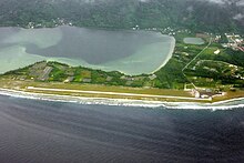 Huahine – Fare Airport from above, in 2009. | |||||||||||
| Summary | |||||||||||
| Airport type | Public | ||||||||||
| Location | Huahine, French Polynesia | ||||||||||
| Elevation AMSL | 7 ft / 2 m | ||||||||||
| Coordinates | 16°41′14″S 151°1′18″W / 16.68722°S 151.02167°WCoordinates: 16°41′14″S 151°1′18″W / 16.68722°S 151.02167°W | ||||||||||
| Map | |||||||||||
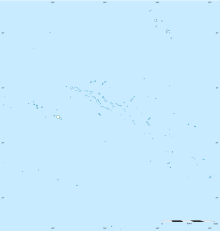 HUH Location within French Polynesia | |||||||||||
| Runways | |||||||||||
| |||||||||||
| Statistics (2018) | |||||||||||
| |||||||||||

Huahine – Fare Airport is an airport serving the island of Huahine in French Polynesia (IATA: HUH, ICAO: NTTH). The airport is located in the northern part of the commune of Fare, on the Island of Huahine Fare, French Polynesia.[3]
In 2006, 151,907 passengers used the airport.[4]
Airlines and destinations[]
| Airlines | Destinations |
|---|---|
| Air Tahiti | Bora Bora, Moorea, Papeete, Raiatea |
Statistics[]
Annual passenger traffic at HUH airport.
See source Wikidata query.
References[]
- ^ "Huahine". WorldAeroData. WorldAeroData. Retrieved 27 July 2011.
- ^ "Résultats d'activité des aéroports français 2018" (PDF). aeroport.fr. Retrieved 31 August 2019.
- ^ "Aéroport de Tahiti gestionnaire des aéroports : Tahiti Faa'a, Bora Bora, Raiatea, Rangiroa. - Accès et parkings".
- ^ "Archived copy". Archived from the original on 2006-11-24. Retrieved 2007-03-06.
{{cite web}}: CS1 maint: archived copy as title (link)
External links[]
- Huahine-Fare Airport
- NTTH – HUAHINE. AIP from French Service d'information aéronautique, effective 27 January 2022.
This article about an Oceanian airport is a stub. You can help Wikipedia by . |
This French Polynesia-related geography article is a stub. You can help Wikipedia by . |
Categories:
- Airports in French Polynesia
- Huahine
- Oceanian airport stubs
- French Polynesia geography stubs