Montluçon – Guéret Airport
Montluçon - Guéret Airport Aéroport de Montluçon - Guéret | |||||||||||||||
|---|---|---|---|---|---|---|---|---|---|---|---|---|---|---|---|
| Summary | |||||||||||||||
| Airport type | Public | ||||||||||||||
| Operator | CCI de Montluçon Gannat | ||||||||||||||
| Serves | Montluçon / Guéret | ||||||||||||||
| Location | Lépaud, Creuse, France | ||||||||||||||
| Elevation AMSL | 1,367 ft / 417 m | ||||||||||||||
| Coordinates | 46°13′34″N 002°21′46″E / 46.22611°N 2.36278°ECoordinates: 46°13′34″N 002°21′46″E / 46.22611°N 2.36278°E | ||||||||||||||
| Map | |||||||||||||||
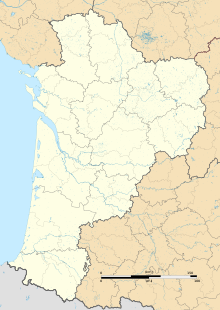 LFBK Location of airport in the Nouvelle-Aquitaine region | |||||||||||||||
| Runways | |||||||||||||||
| |||||||||||||||

Montluçon – Guéret Airport (French: Aéroport de Montluçon - Guéret[2]) (IATA: MCU, ICAO: LFBK) is an airport in Lépaud, a commune in the Creuse department[1] of the Nouvelle-Aquitaine region of France. The airport is located 22.5 km (14 mi) southwest of Montluçon[1] in the Allier department. It is also 45 km (28 mi) east of Guéret[2] in the Creuse department.
Facilities[]
The airport resides at an elevation of 1,367 feet (417 m) above mean sea level. It has one paved runway designated 17/35 with an asphalt surface measuring 1,900 by 45 metres (6,234 ft × 148 ft). It also has a parallel unpaved runway with a grass surface measuring 1,000 by 80 metres (3,281 ft × 262 ft).[1][2]
Statistics[]
References[]
- ^ a b c d LFBK – Montluçon Guéret. AIP from French Service d'information aéronautique, effective 24 February 2022.
- ^ a b c d (in French) Aéroport de Montluçon - Guéret (MCU / LFBK) Archived 2010-03-27 at the Wayback Machine at Union des Aéroports Français
- ^ Airport information for LFBK from DAFIF (effective October 2006)
In August 2021 the airport hosted three classes of the World Gliding Championships[1]
External links[]
- ^ "Official competition web-site". Retrieved 6 August 2021.
- Airports in Nouvelle-Aquitaine
- Buildings and structures in Creuse
- Airports established in 1982
- 1982 establishments in France