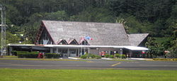
Raiatea Airport
Raiatea Airport | |||||||||||
|---|---|---|---|---|---|---|---|---|---|---|---|
 | |||||||||||
| Summary | |||||||||||
| Airport type | Public | ||||||||||
| Serves | Raiatea, French Polynesia, France | ||||||||||
| Location | Uturoa, French Polynesia | ||||||||||
| Elevation AMSL | 6 ft / 2 m | ||||||||||
| Coordinates | 16°43′23.7″S 151°28′0.94″W / 16.723250°S 151.4669278°WCoordinates: 16°43′23.7″S 151°28′0.94″W / 16.723250°S 151.4669278°W | ||||||||||
| Map | |||||||||||
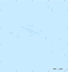 RFP Location of the airport in French Polynesia | |||||||||||
| Runways | |||||||||||
| |||||||||||
| Statistics (2018) | |||||||||||
| |||||||||||
Sources: Aeroport.fr[1] | |||||||||||

Raiatea Airport (also known as Uturoa Airport) is an airport on Raiatea, French Polynesia. It is in the village of Uturoa. The airport was inaugurated in 1962, but did not see service in 1964. A backfilling was built on the north part of the island, as no appropriate site could be found on the coast. Many people use this airport to access the nearby island of Taha'a.
In 2014, 207,722 passengers used the airport.
Airlines and destinations[]
| Airlines | Destinations |
|---|---|
| Air Tahiti | Bora Bora, Huahine-Fare, Maupiti, Moorea, Papeete[2] |
Statistics[]
Annual passenger traffic at RFP airport.
See source Wikidata query.
References[]
- ^ "Résultats d'activité des aéroports français 2018" (PDF). aeroport.fr. Retrieved 31 August 2019.
- ^ "Download forecast schedule – Official website – Air Tahiti". Official website.
This article about an Oceanian airport is a stub. You can help Wikipedia by . |
This French Polynesia-related geography article is a stub. You can help Wikipedia by . |
Categories:
- Airports in French Polynesia
- Oceanian airport stubs
- French Polynesia geography stubs