Interstate 85 in North Carolina
 | ||||
|---|---|---|---|---|
I-85 highlighted in red | ||||
| Route information | ||||
| Maintained by NCDOT | ||||
| Length | 234.6 mi[1] (377.6 km) | |||
| Existed | 1958–present | |||
| Major junctions | ||||
| South end | ||||
| North end | ||||
| Location | ||||
| Counties | Cleveland, Gaston, Mecklenburg, Cabarrus, Rowan, Davidson, Randolph, Guilford, Alamance, Orange, Durham, Granville, Vance, Warren | |||
| Highway system | ||||
| ||||

Interstate 85 (I-85) is an Interstate highway that runs from Montgomery, Alabama to Richmond, Virginia. In North Carolina, I-85 travels 234.6 miles (377.6 km) from the South Carolina state line near Grover, North Carolina to the Virginia state line near Wise. Despite being signed north–south, I-85 physically travels in a southwest-northeast direction across the state. The Interstate highway connects the three most populous metropolitan areas of North Carolina, Metrolina, Piedmont Triad, and Research Triangle, as well as nine of the twenty largest municipalities in the state. Outside of North Carolina, I-85 connects the state with Richmond, Virginia to the north, and Upstate South Carolina and Atlanta, Georgia to the south. I-85 follows several U.S. Highways including US 29 between South Carolina and Greensboro, US 70 between Greensboro and Durham, and US 15 between Durham and Oxford, and US 1 between Henderson and Virginia.
Route description[]

I-85 enters the state from Cherokee County, South Carolina near Grover in Cleveland County, an outer suburb of the Charlotte metropolitan area. After only a few miles, the highway enters Gaston County. Near Kings Mountain, I-85 turns from a northeast trajectory to an eastward one and goes through Gastonia, where it widens from four to six lanes. It stays at six lanes until it reaches Belmont, where the highway widens again to eight lanes.
The highway crosses the Catawba River as it enters Mecklenburg County, then interchanges with I-485 as it passes north of Charlotte-Douglas International Airport. After crossing I-485, it turns northeastward again, bypassing Uptown Charlotte to the west and north. While the route does not enter Uptown, several exits do provide access to the area. An interchange with Interstate 77 north of Uptown provides direct freeway access. The route through Charlotte traverses the northern portion of the city and is more suburban than urban in character, with light industry such as truck terminals, warehouses, small manufacturing facilities, and small office parks lining the highway. It also passes by the University City area and the University of North Carolina at Charlotte.
North of Charlotte, I-85 interchanges with I-485 a second time as it continues northeastward into Cabarrus County. In Concord, it passes through a dense commercial district and provides access to both Concord Mills shopping mall and Charlotte Motor Speedway, afterwards passing south and east of Kannapolis. As of February 2019, the highway between exit 58 (near Concord) and exit 68 near the Rowan County town of China Grove is being rebuilt and expanded from 4 lanes total (two in each direction) with no shoulders. When complete, the route will have 8 total lanes through to its junction with Business 85 south of Lexington.
Between Exits 96 and 102, the northbound and southbound lanes switch places. The southbound lane crosses over the northbound lane just before the northbound lane passes over a small bridge over Hamby Creek. East of the northbound overpass and southbound underpass with Squire Bowers Road, a pair of rest areas which contain the North Carolina Vietnam Veterans Memorial Park are entered from the right, but are still in the median. Only after the underpasses beneath Johnsontown Road does the northbound lane run over the southbound one returning to its proper location.
Approximately 70 miles (110 km) northeast of the Charlotte area is the Triad area, anchored by the cities of Winston-Salem, Greensboro and High Point. I-85 bypasses High Point and also largely bypasses Greensboro. Up until February 2004, I-85 went through the heart of Greensboro and joined Interstate 40 near downtown. Today, I-85 is routed along the Greensboro Urban Loop and meets I-40 east of downtown. Its former route is now known as Business 85.
Interstates 85 and 40 remain joined as they continue eastward to the Triangle region, anchored by the cities of Chapel Hill, Durham and Raleigh. West of Durham near Hillsborough, the two highways split, with I-40 heading southeast through Chapel Hill, Durham and Raleigh while I-85 continues eastward through Durham, then northeastward as it exits the city. In between Greensboro and Durham, 85/40 is 8 lanes wide even through the more suburban stretches. Once 85 hits Durham it temporarily widens to 10 lanes. It takes on a more suburban character once it leaves Durham and then heads into rural areas, bypassing Oxford and Henderson before crossing into Mecklenburg County, Virginia.
Dedicated and memorial names[]

I-85 in North Carolina feature a few dedicated or memorialized stretches of freeway.
- Blue Star Memorial Highway – official North Carolina honorary name of Interstate 85 throughout the state (approved: May 5, 1967).[2][3]
- Senator Marshall Arthur Rauch Highway – official North Carolina name of Interstate 85 through Gaston County (approved: October 3, 1997)[3]
- William James Pharr Bridge – official North Carolina name of Bridge over South Fork River on Interstate 85 in Gaston County (approved: August 5, 1994).[3]
- Cameron Morrison Bridge – official North Carolina name of Bridge over Catawba River on Interstate 85 between Gaston and Mecklenburg counties (approved: March 11, 1983). It is named in honor of Cameron A. Morrison, known as the Good Roads Governor.[3]
- Julius Chambers Highway – official North Carolina name of I-85 between I-77/US 21 and the I-85 Connector (four miles (6.4 km)), in Charlotte. It is named in honor of Julius L. Chambers, who was a lawyer, civil rights leader and educator (dedicated May 24, 2018).[4][5]
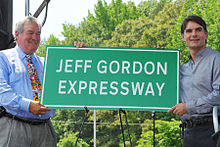
- Jeff Gordon Expressway – official North Carolina name of I-85 from Charlotte city limit to the Mecklenburg/Cabarrus county line in Northeast Mecklenburg County (1.6 mi (2.6 km)).[6] It is named in honor of NASCAR driver Jeff Gordon (dedicated May 25, 2012).[7][8][9][10]
- Yadkin River Veterans Memorial Bridge – official North Carolina name of Bridge over Yadkin River on Interstate 85 between Rowan and Davidson counties (approved: May 11, 2011).[11]
- Bob Timberlake Freeway - official North Carolina name of I-85 from exit 92 to exit 96 in Davidson County.[12]
- Richard Childress Freeway - official North Carolina name of I-85 from exit 96 to exit 102 in Davidson County.[12]
- Congressman J. Howard Coble Highway – official North Carolina name of I-85 from I-40 to Alamance Church Road in Guilford County (approved: December 1, 2016). It is named in honor of Congressman Howard Coble, who represented North Carolina's 6th district for 30 years.[13]
- Sam Hunt Freeway – official North Carolina name of I-85/I-40 from the Guilford County line to one mile east of NC 54 in Graham (approved: September 5, 1997).[3]
- Dr. John H. Franklin Highway – official North Carolina name of I-85/US 70, between Cole Mill Road (exit 173) and US 70 (exit 178), in Durham. It is named in honor of John Hope Franklin, an American Historian and recipient of the Presidential Medal of Freedom.[14]
History[]

Parts of Interstate 85 were already constructed before federal aid was available in the 1950s, as the state had been constructing sections of the Interstate Highway System since 1949. The Lexington Bypass north of Lexington - which at the time was signed U.S. 29 and U.S. 70 - is now a part of Business I-85.[15] This was part of an 80-mile expressway completed in 1955 between Lexington and Hillsborough.[16]
One planned road was the Salisbury bypass, 15 miles (24 km) long with a $1 million 880-foot (270 m) twin-span bridge over the Yadkin River. Construction on the bridge started in 1955 (this date is shown on a plaque, and most sources have used the date), but the lanes were not as wide as federal standards required, and the road had a sharp curve north of the bridge. Both of these characteristics saved money.
The Federal-Aid Highway Act of 1956 provided for 90 percent federal funding of highways that would become part of the Interstate Highway System, and the N.C. Highway Commission used the funds to build the rest of the highway, which opened as I-85 in 1958. The bridge, finished a year earlier, was "grandfathered" despite not meeting standards.[17]
Another section of I-85 opened to traffic on September 9, 1958 when an 11.3-mile (18.2 km) stretch in Mecklenburg County was opened.
The year 1960 saw several sections of the highway open to traffic:[15]
- An 18.3-mile (29.5 km) section of Interstate 85 between Henderson and the Virginia border as well as a 46-mile (74 km) section between Greensboro and western Durham opened to traffic.
- A 15.4-mile portion of U.S. 29/U.S. 70 between Salisbury and Greensboro was incorporated into I-85 when further grade separations and access control were completed.
- A 14-mile (23 km) segment of I-85 known as the "Charlotte Bypass" in Charlotte.
- A 13.8-mile (22.2 km) segment between Greensboro and Whitsett.
By 1965, I-85 from the South Carolina border to Charlotte was complete, while it took until 1970 for the section between Charlotte and Durham to be completed. However, the "Temporary 85" designation would remain on the segment between Lexington and Greensboro until 1984 because there were too many access roads. That year, a new six-lane section opened, resulting in the "Temporary 85" designation to be dropped.[18]
Since its completion, many widening projects have been undertaken on I-85, particularly along the stretch of highway between Gastonia and Durham. By 1988, widening I-85 to six lanes from Greensboro to Burlington was being considered.[19] The plan was later changed to eight lanes.[20] The $175 million project began in 1989. With the opening of a 2.3-mile (3.7 km) section in Alamance County on November 23, 1994, 21 miles (34 km) of I-85/I-40 were eight lanes. An additional 14 miles (23 km) were to be ready by 1996, giving the interstate eight lanes all the way to where I-40 turned southward at Hillsborough.[21]
In addition, Interstate 85 was relocated in 2004, south of Greensboro, forming part of the Greensboro Urban Loop, allowing through traffic to bypass that city's downtown area.[citation needed] Between 2004 and 2008, I-85 was widened to eight lanes around Salisbury.[17]
The I-85 Corridor Improvement Project, located in Rowan County and Davidson County, was a two-phase project to replace the narrow bridge over the Yadkin River and widen the freeway from four to eight lanes.[22] In the first phase, all traffic from the old bridge moved to a new $201 million bridge in August 2012.[17] On March 9, 2013, all eight lanes of the I-85 bridge opened to the public.[23] The project finished eight months ahead of schedule and $44 million under budget.[24]
From May 2010 through April 2014, I-85 was widened from four to eight lanes between exit 49 (near Charlotte Motor Speedway and Concord Mills Mall) and Exit 55.[25]
Current projects[]
Following the completion of the widening of I-85 between exits 49 and 55, a new project was started to widen I-85 from exit 55 (NC 73) in Concord, Cabarrus County northward to exit 68 (NC 152) in China Grove, Rowan County. Like the prior project, I-85 is being doubled in capacity, expanding from two travel lanes in each direction to four travel lanes in each direction. The project is now complete as of May 2021. The first phase (from Exit 55 to Exit 63) begun in Spring 2014, and the second phase (from Exit 63 to Exit 68) begun in Spring 2017.[26] Construction is scheduled to be completed by December 2017.[27] When finished, that will leave I-85 in North Carolina with at least six lanes of highway between Exits 10 (US 29 north / US 74 – Kings Mountain, Shelby) and 164 (I-40 in Hillsborough).
Auxiliary routes[]
| Interstate | City | Type | Notes | |
|---|---|---|---|---|
| Interstate 85 Business | Lexington, High Point, and Greensboro | Business loop | Expressway grade from Lexington-High Point | |
| Interstate 285 | Lexington and Winston-Salem | Connector | Complete concurrency with US 52 | |
| Interstate 485 | Charlotte | Beltway | Uses Huntersville, Matthews and Pineville as control cities | |
| Interstate 785 | Greensboro and Danville | Spur | Currently a 7-mile (11 km) freeway in eastern Guilford County; to be extended. | |
| Interstate 885 | Durham | Connector | Proposed designation along NC 147 and US 70 |
Exit list[]
| County | Location | mi[1] | km | Exit | Destinations | Notes |
|---|---|---|---|---|---|---|
| Cleveland | Grover | 0.0 | 0.0 | Continuation from South Carolina | ||
| | 1.8 | 2.9 | 2 | |||
| | 3.6 | 5.8 | 4 | South end of US 29 overlap; southbound exit and northbound entrance | ||
| | 4.8 | 7.7 | 5 | Dixon School Road | ||
| Kings Mountain | 7.6 | 12.2 | 8 | |||
| Gaston | 10.0 | 16.1 | 10 | North end of US 29 overlap; signed as exits 10A (north/east) and 10B (west) | ||
| Bessemer City | 12.8 | 20.6 | 13 | Edgewood Road – Bessemer City | ||
| Gastonia | 14.5 | 23.3 | 14 | |||
| 17.0 | 27.4 | 17 | Signed as exits 17A (south) and 17B (north) southbound | |||
| 19.0 | 30.6 | 19 | ||||
| 19.7 | 31.7 | 20 | ||||
| 20.6 | 33.2 | 21 | Cox Road – Ranlo | |||
| Lowell | 22.3 | 35.9 | 22 | Main Street – Cramerton, Lowell | ||
| 23.2 | 37.3 | 23 | ||||
| Belmont | 25.7 | 41.4 | 26 | Belmont–Mount Holly Road – Belmont, Mount Holly | To Belmont Abbey College | |
| 26.9 | 43.3 | 27 | ||||
| Mecklenburg | | 29.4 | 47.3 | 29 | Sam Wilson Road | To U.S. National Whitewater Center |
| | 30.3 | 48.8 | 30 | Signed southbound as exits 30B (north/inner) and 30A (south/outer) | ||
| Charlotte | 32.0 | 51.5 | 32 | |||
| 33.2 | 53.4 | 33 | Billy Graham Parkway (Charlotte Route 4) – Farmers Market | To Billy Graham Library | ||
| 34.7 | 55.8 | 34 | ||||
| 35.4 | 57.0 | 35 | Glenwood Drive | |||
| 36.2 | 58.3 | 36 | ||||
| 37.8 | 60.8 | 37 | Beatties Ford Road – Johnson C. Smith University | |||
| 38.2 | 61.5 | 38 | Hybrid interchange | |||
| 38.8 | 62.4 | 39 | Statesville Avenue / Statesville Road | |||
| 40.5 | 65.2 | 40 | Graham Street | |||
| 41.3 | 66.5 | 41 | Sugar Creek Road (Charlotte Route 4) | |||
| 42.3 | 68.1 | 42 | Northbound exit and southbound entrance | |||
| 43.0 | 69.2 | 43 | To Ikea Boulevard | |||
| 44.5 | 71.6 | 45 | Signed as exits 45A (east) and 45B (west) | |||
| 46.2 | 74.4 | 46 | Mallard Creek Church Road | Signed northbound as exits 46A (east) and 46B (west) | ||
| 47.5 | 76.4 | 48 | Turbine interchange; I-77 signed southbound | |||
| Cabarrus | Concord | 49.2 | 79.2 | 49 | Bruton Smith Boulevard / Concord Mills Boulevard | To Concord Mills and Charlotte Motor Speedway |
| 51.8 | 83.4 | 52 | Poplar Tent Road | DDI[28] | ||
| 53.6 | 86.3 | 54 | George W. Liles Parkway / Kannapolis Parkway | |||
| 55.0 | 88.5 | 55 | To Rowan-Cabarrus Community College South Campus; DDI[29] | |||
| 58.0 | 93.3 | 58 | South end of US 601 overlap | |||
| Kannapolis | 59.9 | 96.4 | 60 | Dale Earnhardt Boulevard / Copperfield Boulevard | Signed as exits 60A and 60B northbound | |
| 62.5 | 100.6 | 63 | Lane Street – Kannapolis | |||
| Rowan | Landis | 65.0 | 104.6 | 65 | Old Beatty Ford Road – Landis | Opened November 14, 2019. |
| China Grove | 68.0 | 109.4 | 68 | |||
| Salisbury | 70.4 | 113.3 | 70 | Webb Road | ||
| 71.5 | 115.1 | 71 | Peeler Road | |||
| 72.3 | 116.4 | 72 | Peach Orchard Road | |||
| 73.7 | 118.6 | 74 | Julian Road | |||
| 74.5 | 119.9 | 75 | North end of US 601 overlap; to Rowan–Cabarrus CC North Campus | |||
| 76.0 | 122.3 | 76 | South end of US 52 overlap; formerly signed as exits 76A (south) and 76B (north) | |||
| East Spencer | 79.0 | 127.1 | 79 | Andrews Street – Spencer, East Spencer | ||
| Spencer | 80.4 | 129.4 | 81 | Long Ferry Road – Spencer | ||
| Yadkin River | 82.2 | 132.3 | Yadkin River Veterans Memorial Bridge | |||
| Davidson | | 82.7 | 133.1 | 82 | Permanently closed as of April 2010[22][30][31][32] | |
| | 83.1 | 133.7 | 83 | Permanently closed as of May 2013[22][31][32] | ||
| | 83.4 | 134.2 | 84 | South end of US 29 and west end of US 70 overlap | ||
| | 84.4 | 135.8 | 85 | Clark Road | Permanently closed as of November 2012[33] | |
| | 85.5 | 137.6 | 86 | Belmont Road | ||
| | 87.2 | 140.3 | 87 | North end of US 29/US 52 and east end of US 70 overlap; northbound exit and southbound entrance | ||
| | 88.0 | 141.6 | 88 | |||
| Lexington | 91.1 | 146.6 | 91 | |||
| 93.7 | 150.8 | 94 | Old US 64 | |||
| 96.0 | 154.5 | 96 | ||||
| Thomasville | 101.5 | 163.3 | 102 | Lake Road | ||
| 103.4 | 166.4 | 103 | ||||
| Randolph | Trinity | 105.5 | 169.8 | 106 | Finch Farm Road | |
| 107.5 | 173.0 | 108 | Hopewell Church Road – Trinity | |||
| Archdale | 111.0 | 178.6 | 111 | Main Street – Archdale, Downtown High Point | ||
| Guilford | 112.7 | 181.4 | 113A | |||
| 113.4 | 182.5 | 113B-C | Signed as exits 113B (east) and 113C (west) | |||
| Greensboro | 118.1 | 190.1 | 118 | South end of US 29 and west end of US 70 overlap | ||
| 119.5 | 192.3 | 119 | Groometown Road to Grandover Parkway | Signed as exit 122A southbound | ||
| 120.0 | 193.1 | 120A | North end of US 29 and east end of US 70 overlap; northbound exit and southbound entrance | |||
| 120.4 | 193.8 | 120B | Signed as exit 121 southbound; north end of US 421 overlap | |||
| 121.7 | 195.9 | 122 | Southbound exit and northbound entrance; signed as exits 122B (south) and 122C (north) | |||
| 123.7 | 199.1 | 124 | South Elm–Eugene Street | |||
| 126.0 | 202.8 | 126 | Signed as exits 126A (US 421 South) and 126B (Greensboro); south end of US 421 overlap | |||
| 128.2 | 206.3 | 128 | Alamance Church Road | |||
| 130.2 | 209.5 | 129 | Youngs Mill Road | |||
| 132.0 | 212.4 | 131 | West end of I-40 overlap; hidden I-840 west | |||
| McLeansville | 133.3 | 214.5 | 132 | Mount Hope Church Road | ||
| Whitsett | 136.3 | 219.4 | 135 | Rock Creek Dairy Road | ||
| 138.6 | 223.1 | 138 | ||||
| Alamance | Burlington | 141.5 | 227.7 | 140 | University Drive – Elon | To Elon University |
| 142.5 | 229.3 | 141 | Huffman Mill Road | |||
| 144.2 | 232.1 | 143 | ||||
| 146.3 | 235.4 | 145 | ||||
| Graham | 148.0 | 238.2 | 147 | |||
| 149.0 | 239.8 | 148 | ||||
| Haw River | 150.8 | 242.7 | 150 | Jimmie Kerr Road – Haw River, Roxboro | ||
| Mebane | 153.2 | 246.6 | 152 | Trollingwood Road | ||
| 154.0 | 247.8 | 153 | ||||
| 155.5 | 250.3 | 154 | Mebane–Oaks Road – Mebane | |||
| Orange | | 158.2 | 254.6 | 157 | Buckhorn Road | |
| Efland | 161.3 | 259.6 | 160 | Mount Willing Road – Efland | ||
| 161.9 | 260.6 | 161 | ||||
| Hillsborough | 164.0 | 263.9 | 163 | East end of I-40 overlap | ||
| 165.2 | 265.9 | 164 | Old NC 86 – Hillsborough | |||
| 166.5 | 268.0 | 165 | ||||
| Eno | 170.8 | 274.9 | 170 | West end of US 70 overlap; to Bennett Place | ||
| Durham | Durham | 173.3 | 278.9 | 172 | Northbound exit and southbound entrance; to North Carolina Central University | |
| 174.2 | 280.3 | 173 | Cole Mill Road | |||
| 174.7 | 281.2 | 174A | South end of US 15/US 501 overlap; southbound exit and northbound entrance | |||
| 175.3 | 282.1 | 174B | Hillandale Road | |||
| 176.0 | 283.2 | 175 | To NC School of Science & Math and Duke Homestead | |||
| 177.2 | 285.2 | 176 | North end of US 501 overlap; signed northbound as exits 176A (Gregson St) and 176B (Roxboro) | |||
| 178.2 | 286.8 | 177 | To North Carolina Central University | |||
| 179.2 | 288.4 | 178 | East end of US 70 overlap | |||
| 180.6 | 290.6 | 179 | East Club Boulevard | |||
| 181.3 | 291.8 | 180 | Glenn School Road | |||
| Gorman | 183.0 | 294.5 | 182 | Red Mill Road | ||
| 184.5 | 296.9 | 183 | Redwood Road | |||
| Granville | | 186.7 | 300.5 | 186 | North end of US 15 overlap; signed northbound as exits 186A (US 15) and 186B (Butner) | |
| Butner | 189.7 | 305.3 | 189 | Gate Two Road – Butner | ||
| 192.0 | 309.0 | 191 | ||||
| | 202.8 | 326.4 | 202 | |||
| Oxford | 205.1 | 330.1 | 204 | |||
| 207.5 | 333.9 | 206 | ||||
| Vance | | 210.6 | 338.9 | 209 | Poplar Creek Road | To Vance–Granville Community College |
| Henderson | 213.0 | 342.8 | 212 | Ruin Creek Road | ||
| 214.0 | 344.4 | 213 | West end of US 158 overlap | |||
| 215.5 | 346.8 | 214 | ||||
| 216.4 | 348.3 | 215 | East end of US 158 overlap | |||
| 218.0 | 350.8 | 217 | Satterwhite Point Road | To Satterwhite Point | ||
| 219.0 | 352.4 | 218 | Southbound exit and northbound entrance | |||
| Middleburg | 221.0 | 355.7 | 220 | |||
| Warren | Manson | 224.5 | 361.3 | 223 | Manson-Drewry Road | |
| | 226.8 | 365.0 | 226 | Ridgeway-Drewry Road | ||
| | 229.7 | 369.7 | 229 | Oine Road | ||
| | 233.8 | 376.3 | 233 | |||
| | 234.6 | 377.6 | Continuation into Virginia | |||
1.000 mi = 1.609 km; 1.000 km = 0.621 mi
| ||||||
See also[]
|
References[]
- ^ Jump up to: a b Google (December 27, 2012). "Interstate 85" (Map). Google Maps. Google. Retrieved December 27, 2012.
- ^ "NCDOT: NC Blue Star Memorial Marker Locations". Archived from the original on May 22, 2011. Retrieved June 19, 2011.
- ^ Jump up to: a b c d e "North Carolina Memorial Highways and other Named Facilities" (PDF). Archived from the original (PDF) on May 19, 2011. Retrieved June 19, 2011.
- ^ Crump, Steve (May 25, 2018). "A highway honor for a civil rights hero". Charlotte, NC: WBTV. Retrieved June 1, 2018.
- ^ Lowe, Jonathan (May 24, 2018). "Part of I-85 named after prominent attorney, civil rights activist". Charlotte, NC: Spectrum News. Retrieved June 1, 2018.
- ^ Busbee, Jay (May 26, 2013). "There is, alas, a speed limit on the Jeff Gordon Expressway". Yahoo! Sports. Retrieved September 2, 2013.
- ^ Flores, Adrianne; Brad Broders (October 19, 2011). "Mecklenburg County Commissioners approve 'Jeff Gordon Expressway'". Raleigh, NC: News 14 Carolina. Archived from the original on October 25, 2011. Retrieved October 19, 2011.
- ^ Lyttle, Steve (May 24, 2012). "Ready for the Jeff Gordon Expressway?". Gulfport, MS: Sun Herald.com. Retrieved June 19, 2012.[permanent dead link]
- ^ "Flickr - I-85 Jeff Gordon Expressway Ceremony". Retrieved June 19, 2012.
- ^ "NCDOT dedicates section of I-85 in Mecklenburg County as the Jeff Gordon Expressway". Hendrick Motorsports. May 25, 2012. Retrieved October 6, 2015.
- ^ "Bill to rename Yadkin River Bridge passes". Salisbury Post. May 13, 2011. Retrieved May 6, 2012.
- ^ Jump up to: a b Stratton, Seth (December 16, 2008). "DOT dedicates part of I-85 as Childress freeway". the-dispatch.com. The-Dispatch.com. Retrieved June 22, 2015.
- ^ "State names part of I-85 in Guilford County for late Rep. Howard Coble". News & Record. Greensboro, NC. December 1, 2016. Retrieved December 6, 2016.
- ^ Baumgartner Vaughan, Dawn (November 27, 2017). "Why I-85 in Durham is now the 'Dr. John H. Franklin Highway'". News & Observer. Raleigh, NC. Retrieved November 28, 2017.
- ^ Jump up to: a b North Carolina Department of Transportation. Facts: Interstate 85, Page 1. NCDOT Web site. Accessed April 21, 2007. Archived February 3, 2007, at the Wayback Machine
- ^ "This day in history". News and Record. January 9, 2016. Retrieved November 9, 2016.
- ^ Jump up to: a b c Turner, Walter R. (August 5, 2012). "The mysterious Yadkin River bridge". Salisbury Post. Retrieved August 7, 2012.
- ^ North Carolina Department of Transportation. Facts: Interstate 85, Page 2. NCDOT Web site. Accessed April 21, 2007.
- ^ "I-85 Traffic Flow May Be Smoother". The Charlotte Observer. Charlotte, NC. Associated Press. December 16, 1988. p. 5B.
- ^ "North Carolina - Wider I-85 Recommended". The Charlotte Observer. Charlotte, NC. January 27, 1989. p. 2B.
- ^ Hall, David A. (November 23, 1994). "Interstate 40/85 Freeway Isn't Free of Construction". Greensboro News & Record. Greensboro, NC. p. A1.
- ^ Jump up to: a b c "NCDOT: I-85 Corridor Improvement Project". Archived from the original on July 8, 2011. Retrieved June 19, 2011.
- ^ "NCDOT to open new I-85 Yadkin River bridge on Friday". WBTV. Charlotte, NC. April 6, 2013. Retrieved April 17, 2014.
- ^ "The I-85 Yadkin River Bridge, Salisbury, NC". Archived from the original on April 19, 2014. Retrieved April 17, 2014.
- ^ Lyttle, Steve (April 3, 2012). "Part of widened I-85 to open this weekend". Charlotte Observer. Retrieved April 17, 2014.
- ^ "Archived copy". Archived from the original on March 29, 2017. Retrieved March 28, 2017.CS1 maint: archived copy as title (link)
- ^ Lyttle, Steve (April 12, 2012). "DOT awards contract for I-85 widening in Cabarrus County". Charlotte Observer. Retrieved April 14, 2014.
- ^ Lyttle, Steve (September 8, 2014). "Diverging diamond opens on Poplar Tent Road". Charlotte, NC: Charlotte Observer. Retrieved September 8, 2014.
- ^ Marusak, Joe (February 4, 2012). "New interchange planned for bottlenecked I-77 exit". Charlotte, NC: Charlotte Observer. Archived from the original on June 1, 2012. Retrieved March 2, 2013.
- ^ "SalisburyPost.com: Safety concerns lead to closing of Wil-Cox Bridge; no timeframe on reopening". Archived from the original on July 15, 2011. Retrieved February 18, 2011.
- ^ Jump up to: a b "NC 150 Route Change (2012-03-01)" (PDF). North Carolina Department of Transportation. March 1, 2012. Retrieved May 26, 2013.
- ^ Jump up to: a b NC 150 Route Change (2012-01-04) (PDF) (Map). North Carolina Department of Transportation. January 4, 2012. Retrieved May 26, 2013.
- ^ Staff (July 27, 2011). "NCDOT to close Clark Road entrance and exits ramps on I-85 north, section of Snider Kines Road in Davidson County starting Monday". Project Details. North Carolina Department of Transportation. Archived from the original on April 19, 2014. Retrieved December 26, 2012.
External links[]
Route map:

| ( • help)
|
 Media related to Interstate 85 in North Carolina at Wikimedia Commons
- I-85 Corridor Improvement Project
- Interstate Highways in North Carolina
- Interstate 85
- Transportation in Charlotte, North Carolina
- Transportation in Durham, North Carolina
- Transportation in Greensboro, North Carolina
- Research Triangle
- Transportation in Cleveland County, North Carolina
- Transportation in Gaston County, North Carolina
- Transportation in Mecklenburg County, North Carolina
- Transportation in Cabarrus County, North Carolina
- Transportation in Rowan County, North Carolina
- Transportation in Davidson County, North Carolina
- Transportation in Randolph County, North Carolina
- Transportation in Guilford County, North Carolina
- Transportation in Alamance County, North Carolina
- Transportation in Orange County, North Carolina
- Transportation in Durham County, North Carolina
- Transportation in Granville County, North Carolina
- Transportation in Vance County, North Carolina
- Transportation in Warren County, North Carolina
- Jeff Gordon