List of bridges in Zambia
Historical or architectural interest bridges[]
| Name | Distinction | Length | Type | Carries Crosses |
Opened | Location | Province | Ref. | ||
|---|---|---|---|---|---|---|---|---|---|---|
 |
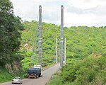
1 | 300 m (980 ft) | Suspension Steel |
Zambezi |
1977 | Chinyingi 13°21′10.5″S 23°00′44.8″E / 13.352917°S 23.012444°E |
North-Western Province | [1] |

Major bridges[]


References[]
- Nicolas Janberg, Structurae.com, International Database for Civil and Structural Engineering
- Others references
- ^ McIntyre, Chris (1996). "Chinyingi Suspension Bridge". Zambia - Bradt Travel Guides. p. 500.
- ^ Keiji Yamazaki, Tomohiko Kashiwamura, Masato Otsubo & Jun Yamazaki. "Chirundu Bridge Construction Project in Zambia/Zimbabwe" (PDF). The Importance of Design and Technical Management in International Bridge.CS1 maint: multiple names: authors list (link)
- ^ "Victoria Falls Bridge". asce.org - American Society of Civil Engineers.
- ^ "Project : Kazungula Bridge, Botswana and Zambia" (PDF). afdb.org - African Development Bank. July 2011.
See also[]
| Wikimedia Commons has media related to List of bridges in Zambia |
Further reading[]
- Prade, Marcel (1990). Les Grands Ponts du Monde : Ponts Remarquables Hors d'Europe (in French). Poitiers: Brissaud. ISBN 2-902170-68-8.

Categories:
- Lists of bridges by country
- Bridges in Zambia
- Zambia transport-related lists
- Lists of buildings and structures in Zambia