Crossing
Carries
Location
Built
Coordinates
Image
Connecticut [ ]
Amtrak Old Saybrook – Old Lyme Bridge
Amtrak Northeast Corridor
Old Saybrook and Old Lyme
1907
41°18′39″N 72°20′57″W / 41.31083°N 72.34917°W / 41.31083; -72.34917 (Amtrak Old Saybrook – Old Lyme Bridge )
Raymond E. Baldwin Bridge
I-95 / US 1
1948, 1993
41°19′09″N 72°20′51″W / 41.31917°N 72.34750°W / 41.31917; -72.34750 (Raymond E. Baldwin Bridge )
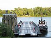
Chester–Hadlyme Ferry
Route 148
Chester and Lyme
1769
41°25′11″N 72°25′50″W / 41.41972°N 72.43056°W / 41.41972; -72.43056 (Chester-Hadlyme Ferry )
East Haddam Bridge
Route 82
Haddam and East Haddam
1913
41°27′05″N 72°27′52″W / 41.45139°N 72.46444°W / 41.45139; -72.46444 (East Haddam Bridge )
Providence and Worcester railroad bridge
Middletown and Portland
41°34′00″N 72°38′52″W / 41.56667°N 72.64778°W / 41.56667; -72.64778 (Providence and Worcester railroad bridge )
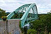
Arrigoni Bridge
Route 17 / Route 66
1938
41°34′09″N 72°38′55″W / 41.56917°N 72.64861°W / 41.56917; -72.64861 (Arrigoni Bridge )
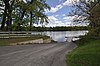
Rocky Hill – Glastonbury Ferry
Route 160
Rocky Hill and Glastonbury
1655
41°39′57″N 72°37′40″W / 41.66583°N 72.62778°W / 41.66583; -72.62778 (Rocky Hill - Glastonbury Ferry )
William H. Putnam Memorial Bridge
Route 3
Wethersfield and Glastonbury
1959
41°42′51″N 72°38′27″W / 41.71417°N 72.64083°W / 41.71417; -72.64083 (William H. Putnam Memorial Bridge )
Charter Oak Bridge
US 5 / Route 15
Hartford and East Hartford
1942, 1991
41°45′11″N 72°39′18″W / 41.75306°N 72.65500°W / 41.75306; -72.65500 (Charter Oak Bridge )
Founders Bridge
Route 2
1958
41°45′56″N 72°39′55″W / 41.76556°N 72.66528°W / 41.76556; -72.66528 (Founders Bridge )
Morgan G. Bulkeley Bridge
I-84 / US 6 / US 44
1908 (widened 1964)
41°46′09″N 72°39′54″W / 41.76917°N 72.66500°W / 41.76917; -72.66500 (Morgan G. Bulkeley Bridge )
Connecticut Southern railroad bridge
c. 1873
41°46′35″N 72°39′27″W / 41.77639°N 72.65750°W / 41.77639; -72.65750 (Connecticut Southern railroad bridge )
Captain John Bissell Memorial Bridge
I-291 and pedestrian/bike path
Windsor and South Windsor
1957
41°48′47″N 72°38′40″W / 41.81306°N 72.64444°W / 41.81306; -72.64444 (Captain John Bissell Memorial Bridge )
Dexter Coffin Bridge
I-91
Windsor Locks and East Windsor
1959
41°55′00″N 72°37′22″W / 41.91667°N 72.62278°W / 41.91667; -72.62278 (Dexter Coffin Bridge )
Bridge Street Bridge
Route 140
1992
41°55′45″N 72°37′27″W / 41.92917°N 72.62417°W / 41.92917; -72.62417 (Bridge Street (Windsor Locks, CT) )
Warehouse Point railroad bridge
Amtrak New Haven – Springfield Line
Suffield and Enfield
1903
41°56′36″N 72°36′50″W / 41.94333°N 72.61389°W / 41.94333; -72.61389 (Amtrak/Springfield Terminal Railroad Bridge )
Enfield–Suffield Covered Bridge (destroyed 1900)
1832
41°58′30.34″N 72°36′22.31″W / 41.9750944°N 72.6061972°W / 41.9750944; -72.6061972 (Enfield–Suffield Covered Bridge )
Enfield–Suffield Veterans Bridge
Route 190
1966
41°59′23″N 72°36′13″W / 41.98972°N 72.60361°W / 41.98972; -72.60361 (Enfield–Suffield Veterans Bridge )
Suffield and Thompsonville Bridge (demolished 1971)
1893
41°59′57″N 72°36′25.56″W / 41.99917°N 72.6071000°W / 41.99917; -72.6071000 (Suffield and Thompsonville Bridge )
Massachusetts [ ]
Julia B. Buxton Bridge (South End Bridge)
US 5
Agawam and Springfield
1954
42°04′53″N 72°34′58″W / 42.08139°N 72.58278°W / 42.08139; -72.58278 (Springfield South End Bridge )
Memorial Bridge
Route 147
West Springfield and Springfield
1922
42°05′56″N 72°35′42���W / 42.09889°N 72.59500°W / 42.09889; -72.59500 (Springfield Memorial Bridge )
Old Toll Bridge
1816
42°5′59.68″N 72°35′46.47″W / 42.0999111°N 72.5962417°W / 42.0999111; -72.5962417 (Old Toll Bridge (removed) )
CSX Berkshire rail bridge
CSX Berkshire Subdivision
1873
42°06′05″N 72°35′57″W / 42.10139°N 72.59917°W / 42.10139; -72.59917 (CSX Berkshire rail bridge )
Arthur J. McKenna Bridge (North End Bridge)
US 20
1924
42°06′31″N 72°36′51″W / 42.10861°N 72.61417°W / 42.10861; -72.61417 (Springfield North End Bridge )
I-91 bridge
I-91
West Springfield and Chicopee
1966
42°08′07″N 72°36′55″W / 42.13528°N 72.61528°W / 42.13528; -72.61528 (Interstate 91 Bridge )
Chicopee – West Springfield Bridge (demolished 1987)
42°8′38.39″N 72°37′7.11″W / 42.1439972°N 72.6186417°W / 42.1439972; -72.6186417 (Chicopee – West Springfield Bridge )
Massachusetts Turnpike bridge
I-90
1957
42°09′14″N 72°37′40″W / 42.15389°N 72.62778°W / 42.15389; -72.62778 (Interstate 90 (Massachusetts Turnpike) bridge )
Jones Ferry
Holyoke and Chicopee
42°10′18″N 72°37′43″W / 42.17167°N 72.62861°W / 42.17167; -72.62861 (Jones Ferry )
I-391 bridge
I-391
1979
42°11′24″N 72°36′36″W / 42.19000°N 72.61000°W / 42.19000; -72.61000 (Interstate 391 bridge )
Willimansett Bridge
Route 116 / Route 141
1891, 2015
42°11′42″N 72°36′05″W / 42.19500°N 72.60139°W / 42.19500; -72.60139 (Willimansett Bridge )
Springfield Terminal railroad bridge
42°11′43″N 72°36′02″W / 42.19528°N 72.60056°W / 42.19528; -72.60056 (Springfield Terminal railroad bridge )
Vietnam Memorial Bridge
Route 116
Holyoke and South Hadley
1990
42°12′42″N 72°35′46″W / 42.21167°N 72.59611°W / 42.21167; -72.59611 (Vietnam Memorial Bridge )
Joseph E. Muller Bridge
US 202
1958
42°12′58″N 72°36′28″W / 42.21611°N 72.60778°W / 42.21611; -72.60778 (Joseph E. Muller Bridge )
Northampton Toll Bridge
Northampton and Hadley
1808
42°20′11″N 72°37′04″W / 42.33639°N 72.61778°W / 42.33639; -72.61778 (Northampton Toll Bridge )
Calvin Coolidge Bridge
Route 9
1937
42°20′11″N 72°37′04″W / 42.33639°N 72.61778°W / 42.33639; -72.61778 (Calvin Coolidge Bridge )
Norwottuck Rail Trail Bridge
Norwottuck Rail Trail
1887
42°20′14″N 72°37′07″W / 42.33722°N 72.61861°W / 42.33722; -72.61861 (Norwottuck Rail Trail Bridge )
Hatfield Bridge (dismantled 1823)
Toll Bridge passed by state legislature March 8, 1803 without funding. Town purchase it by lottery, was completed October 20, 1807 and dismantled on July 7, 1823. Bridge was located on Bridge Lane, Hatfield, MA
Hatfield and Hadley
1807
42°21′55.44″N 72°35′21.65″W / 42.3654000°N 72.5893472°W / 42.3654000; -72.5893472 (Hatfield Bridge, Bridge Lane, Hatfield, MA )
Sunderland Bridge
Route 116
Deerfield and Sunderland
1937
42°28′03″N 72°35′06″W / 42.46750°N 72.58500°W / 42.46750; -72.58500 (Sunderland Bridge )
Springfield Terminal railroad bridge
Deerfield and Montague
42°33′44″N 72°33′22″W / 42.56222°N 72.55611°W / 42.56222; -72.55611 (Springfield Terminal railroad bridge )
Canalside Rail Trail Bridge
Deerfield and Montague
c. 1880, 1936
42°34′45.30″N 72°34′29.53″W / 42.5792500°N 72.5748694°W / 42.5792500; -72.5748694 (Canalside Rail Trail Bridge )
Montague City Covered Bridge (destroyed 1936)
Greenfield and Montague
42°34′49.1″N 72°34′44.9″W / 42.580306°N 72.579139°W / 42.580306; -72.579139 (Montague City Covered Bridge )
Montague trolley bridge (destroyed 1936)
42°34′49.1″N 72°34′45.9″W / 42.580306°N 72.579417°W / 42.580306; -72.579417 (Montague trolley bridge )
General Pierce Bridge
1947
42°34′49″N 72°34′47″W / 42.58028°N 72.57972°W / 42.58028; -72.57972 (General Pierce Bridge )
Turners Falls Road Bridge
1936
42°36′33″N 72°33′41″W / 42.60917°N 72.56139°W / 42.60917; -72.56139 (Turner Falls Road Bridge )
Gill–Montague Bridge
Gill and Montague
1937
42°36′40″N 72°33′11″W / 42.61111°N 72.55306°W / 42.61111; -72.55306 (Gill–Montague Bridge )
French King Bridge
Route 2
Gill and Erving
1931
42°35′52″N 72°29′48″W / 42.59778°N 72.49667°W / 42.59778; -72.49667 (French King Bridge )
Bennett's Meadow Bridge
Route 10
Northfield
1969
42°41′00″N 72°28′18″W / 42.68333°N 72.47167°W / 42.68333; -72.47167 (Route 10 bridge )
Rail bridge
New England Central Railroad
1903
42°42′22.40″N 72°27′33″W / 42.7062222°N 72.45917°W / 42.7062222; -72.45917 (Rail bridge, Northfield, MA )
Schell Bridge (closed)
1903
42°42′44″N 72°27′12″W / 42.71222°N 72.45333°W / 42.71222; -72.45333 (Schell Bridge (closed) )
Rail bridge (demolished)
Boston and Maine Railroad Fort Hill Branch (former)
Vernon and Hinsdale
1913
42°44′14″N 72°27′45″W / 42.737098°N 72.462587°W / 42.737098; -72.462587 (Fort Hill Branch bridge )
Rail bridge (partially demolished)
Boston and Maine Railroad Cheshire Branch (former)
Brattleboro and Hinsdale
42°50′16.38″N 72°32′46.21″W / 42.8378833°N 72.5461694°W / 42.8378833; -72.5461694 (Cheshire Branch bridge )
VT/NH Route 119 bridge
VT 119 NH 119
1920
42°51′05″N 72°33′10″W / 42.85139°N 72.55278°W / 42.85139; -72.55278 (Route 119 bridge )
United States Navy Seabees Bridge
VT 9 NH 9
Brattleboro and Chesterfield
2003
42°53′02″N 72°33′07″W / 42.88389°N 72.55194°W / 42.88389; -72.55194 (United States Navy Seabees Bridge )
Route 123 bridge
VT 123 NH 123
Westminster and Walpole
1910
43°05′04″N 72°26′00″W / 43.08444°N 72.43333°W / 43.08444; -72.43333 (Route 123 bridge )
Vilas Bridge (closed)
Bellows Falls and North Walpole
1930
43°08′07″N 72°26′25″W / 43.13528°N 72.44028°W / 43.13528; -72.44028 (Vilas Bridge )
Stone Arch Bridge
Vermont Rail (Green Mountain)
43°08′09″N 72°26′25″W / 43.13583°N 72.44028°W / 43.13583; -72.44028 (Stone Arch Bridge )
New England Central railroad bridge
43°08′17″N 72°26′48″W / 43.13806°N 72.44667°W / 43.13806; -72.44667 (New England Central railroad bridge )
Arch Bridge
1984
43°08′17″N 72°26′54″W / 43.13806°N 72.44833°W / 43.13806; -72.44833 (Arch Bridge )
Cheshire Bridge
VT 11 NH 11
Springfield and Charlestown
1806,1906,1930
43°15′37″N 72°25′38″W / 43.26028°N 72.42722°W / 43.26028; -72.42722 (Cheshire Bridge )
Route 12 bridge
VT 12 NH 12
Ascutney and Claremont
1969
43°24′11″N 72°24′01″W / 43.40306°N 72.40028°W / 43.40306; -72.40028 (Route 12 bridge )
New England Central railroad bridge
Windsor and Cornish
43°28′11″N 72°23′19″W / 43.46972°N 72.38861°W / 43.46972; -72.38861 (New England Central railroad bridge )
Cornish–Windsor Covered Bridge
1866
43°28′25″N 72°23′01″W / 43.47361°N 72.38361°W / 43.47361; -72.38361 (Cornish–Windsor Covered Bridge )
I-89 bridge
I-89
Hartford and Lebanon
1966
43°38′03″N 72°19′43″W / 43.63417°N 72.32861°W / 43.63417; -72.32861 (Interstate 89 bridge )
Railroad bridge
White River Junction and West Lebanon
43°38′49″N 72°18′48″W / 43.64694°N 72.31333°W / 43.64694; -72.31333 (rail bridge (abandoned) )
US-4 bridge
US 4
1936, 2015
43°39′02″N 72°18′51″W / 43.65056°N 72.31417°W / 43.65056; -72.31417 (US Route 4 bridge )
Ledyard Bridge
VT 10A NH 10A
Norwich and Hanover
1998
43°42′13″N 72°17′59″W / 43.70361°N 72.29972°W / 43.70361; -72.29972 (Ledyard Bridge )
Lyme–East Thetford Bridge
VT 113 East Thetford Road
East Thetford and Lyme
1937
43°48′43″N 72°10′59″W / 43.81194°N 72.18306°W / 43.81194; -72.18306 (Route 113 bridge )
Morey Memorial Bridge
VT 25A NH 25A
Fairlee and Orford
1937
43°54′25″N 72°08′22″W / 43.90694°N 72.13944°W / 43.90694; -72.13944 (Morey Memorial Bridge )
Piermont Bridge
VT 25 NH 25
Bradford and Piermont
1929
43°58′40″N 72°06′43″W / 43.97778°N 72.11194°W / 43.97778; -72.11194 (Piermont Bridge )
Bedell Covered Bridge (destroyed by wind, 1979)
South Newbury and Haverhill
1805, 1823, 1862, 1866, 1979
44°02′43″N 72°04′27″W / 44.04528°N 72.07417°W / 44.04528; -72.07417 (Bedell Covered Bridge (missing) )
Newbury Crossing Road
Newbury and Haverhill
1970
44°03′58″N 72°03′05″W / 44.06611°N 72.05139°W / 44.06611; -72.05139 (Newbury Crossing Road bridge )
Ranger Bridge
US 302
Wells River and Woodsville
1917, 1923
44°09′14″N 72°02′27″W / 44.15389°N 72.04083°W / 44.15389; -72.04083 (Ranger Bridge )
Wells River Bridge (closed)
Boston and Maine Corporation (railroad, upper level), road (lower level, until 1917)
1805, 1853, 1903
44°09′15″N 72°02′26″W / 44.15417°N 72.04056°W / 44.15417; -72.04056 (Wells River Bridge (closed) )
Frazier Road bridge
McIndoe Falls and Monroe
1937
44°15′42″N 72°03′32″W / 44.26167°N 72.05889°W / 44.26167; -72.05889 (Frazier Road Bridge )
Barnet Road bridge
Barnet and Monroe
1930
44°17′13″N 72°03′25″W / 44.28694°N 72.05694°W / 44.28694; -72.05694 (Barnet Road Bridge )
I-93 bridge
I-93
Waterford and Littleton
1976, 1981
44°20′34″N 71°53′27″W / 44.34278°N 71.89083°W / 44.34278; -71.89083 (Interstate 93 bridge )
Route 18 bridge
VT 18 NH 18
1934
44°20′33″N 71°53′20″W / 44.34250°N 71.88889°W / 44.34250; -71.88889 (Route 18 bridge )
Whitcomb Bridge
Gilman and Dalton
1997
44°24′39″N 71°43′23″W / 44.41083°N 71.72306°W / 44.41083; -71.72306 (Gilman Road )
old Whitcomb Bridge
pedestrian traffic only
1928
44°24′40.34″N 71°43′21.45″W / 44.4112056°N 71.7226250°W / 44.4112056; -71.7226250 (old Gilman Road )
Twin State railroad bridge
South Lunenburg and Dalton
1928
44°25′38″N 71°40′35″W / 44.42722°N 71.67639°W / 44.42722; -71.67639 (Twin State railroad bridge )
Mount Orne Covered Bridge
Lunenburg and South Lancaster
1911
44°27′36″N 71°39′10″W / 44.46000°N 71.65278°W / 44.46000; -71.65278 (Mount Orne Covered Bridge )
Route 2 bridge
US 2
Guildhall and Lancaster
1950
44°29′46″N 71°35′39″W / 44.49611°N 71.59417°W / 44.49611; -71.59417 (Route 2 bridge )
Guildhall Road
Guildhall and Northumberland
1984
44°33′51″N 71°33′31″W / 44.56417°N 71.55861°W / 44.56417; -71.55861 (Guildhall Road )
Janice Peaslee Bridge
Maidstone and Stratford
1893, 2005
44°39′6.69″N 71°33′45″W / 44.6518583°N 71.56250°W / 44.6518583; -71.56250 (Janice Peaslee Bridge )
St. Lawrence and Atlantic Railroad bridge
Bloomfield and North Stratford
44°45′08″N 71°37′52″W / 44.75222°N 71.63111°W / 44.75222; -71.63111 (St. Lawrence and Atlantic Railroad bridge )
Route 105 bridge
VT 105
1947
44°45′09″N 71°37′50″W / 44.75250°N 71.63056°W / 44.75250; -71.63056 (Route 105 bridge )
Columbia Bridge
Lemington and Columbia
1912
44°51′11″N 71°33′05″W / 44.85306°N 71.55139°W / 44.85306; -71.55139 (Columbia Bridge )
Route 26 bridge
VT 26 NH 26
Lemington and Colebrook
1953
44°53′56″N 71°30′27″W / 44.89889°N 71.50750°W / 44.89889; -71.50750 (Route 26 bridge )
Route 114 bridge
VT 114 Main Street
Canaan and West Stewartstown
1990
44°59′45″N 71°32′05″W / 44.99583°N 71.53472°W / 44.99583; -71.53472 (Route 114 bridge )
Railroad bridge (former)
Baltimore truss bridge, once used by Maine Central Railroad and North Stratford Railroad ; now used by hikers and snowmobilers.[1] [2] [3] c. 1903[4]
44°59′59.2″N 71°31′45.4″W / 44.999778°N 71.529278°W / 44.999778; -71.529278 (unknown through-truss bridge )
Canaan–Stewartstown Bridge
Beecher Falls and Stewartstown
1930
45°00′28″N 71°30′27″W / 45.00778°N 71.50750°W / 45.00778; -71.50750 (Canaan–Stewartstown Bridge )
New Hampshire [ ]
Route 3 bridge
US 3
Pittsburg and Clarksville
1931
45°01′15″N 71°27′50″W / 45.02083°N 71.46389°W / 45.02083; -71.46389 (Route 3 bridge )
Pittsburg–Clarksville Covered Bridge (closed 1981)
c. 1876
45°03′16″N 71°24′25″W / 45.05444°N 71.40694°W / 45.05444; -71.40694 (Pittsburg–Clarksville Covered Bridge )
Route 145 bridge
NH 145
2006[5]
45°02′57″N 71°23′29″W / 45.04917°N 71.39139°W / 45.04917; -71.39139 (Route 145 bridge )
Murphy Dam Road
unpaved access road
1938[6]
45°02′56.5″N 71°22′57.5″W / 45.049028°N 71.382639°W / 45.049028; -71.382639 (Murphy Dam Road )
Forest Access Road
logging traffic
Pittsburg
45°04′22″N 71°18′08″W / 45.07278°N 71.30222°W / 45.07278; -71.30222 (Pittsburg Forest Access Road )
Magalloway Road
logging traffic
45°07′05″N 71°12′31″W / 45.11806°N 71.20861°W / 45.11806; -71.20861 (Magalloway Road )
Scott Brook Road
logging traffic
45°10′54″N 71°10′38″W / 45.18167°N 71.17722°W / 45.18167; -71.17722 (Scott Brook Road )
Route 3 bridge
US 3
1961
45°11′23″N 71°11′24″W / 45.18972°N 71.19000°W / 45.18972; -71.19000 (Route 3 bridge )