List of districts of Andhra Pradesh
| Districts of Andhra Pradesh | |
|---|---|
 | |
| Category | Districts |
| Location | Andhra Pradesh |
| Populations | Vizianagaram – 2,342,868 (lowest); East Godavari – 5,151,549 (highest) |
| Areas | Srikakulam – 5,837 km2 (2,254 sq mi) (smallest); Anantapuram – 19,130 km2 (7,390 sq mi) (largest) |
| Government | |
| Subdivisions | |
The state of Andhra Pradesh is divided into 13 districts spread across two unofficial regions —Coastal Andhra and Rayalaseema. Coastal Andhra consists of East Godavari, Guntur, Krishna, Nellore, Prakasam, Srikakulam, Visakhapatnam, Vizianagaram and West Godavari districts. Rayalaseema comprises Anantapur, Chittoor, Kadapa and Kurnool districts. Anantapur is the largest district in area while Srikakulam is the smallest. East Godavari is the most populous whereas Vizianagaram is the least populous. The districts are further divided into two or more revenue divisions and mandals for administrative purposes.
History[]
At the time of Independence the present day Andhra Pradesh was a part of Madras State. Coastal Andhra and Rayalaseema were seperated from Madras state to form Andhra State in 1953.[citation needed]
As a result of the 1956 States Reorganisation Act, the state's boundaries were re-organized following linguistic lines. On 1 November 1956, Andhra State and the Telangana region of Hyderabad State were merged to form the united Andhra State and was renamed as Andhra Pradesh. Andhra Pradesh while formation had 11 districts. They are as follows:[citation needed]
- Anantapur, Chittoor, East Godavari, Guntur, Kadapa, Krishna, Kurnool, Nellore, Prakasam, Srikakulam, Visakhapatnam and West Godavari.
- Prakasam district was created out of parts of Guntur district, Nellore district and Kurnool district in 1970.
- Vizianagaram district was created out of parts of Visakhapatnam district and Srikakulam district in 1979.
After the bifurcation of Telangana, Andhra Pradesh lost 9 districts to the new state but was given several tribal-dominated mandals from Khammam district as part of the Polavaram project. These were added to East and West Godavari districts respectively.[citation needed]
On 26 January, 2022, the Y. S. Jagan Mohan Reddy government in Andhra Pradesh has proposed 13 new districts and notified under AP Districts Formation Act, Section 3(5).[1]
They are as follows: Srikakulam, Vizianagaram, Manyam, Alluri Sitarama Raju district, Visakhapatnam, Anakapalli, Kakinada, Kona Seema, East Godavari, West Godavari, Eluru, Krishna, NTR district, Guntur, Bapatla, Palnadu, Prakasam, Nellore, Kurnool, Nandyal, Ananthapuram, Sri Satyasai district, Kadapa, Annamayya district, Chittoor, Sri Balaji district.[1]
Districts[]
| Code[3] | District | Headquarters | Largest city | Revenue divisions | Mandals | Population | Area (in sq.km) |
Density (per sq.km) |
Sex ratio | Map |
|---|---|---|---|---|---|---|---|---|---|---|
| SR | Srikakulam | Srikakulam | Srikakulam | 2 | 30 | 2,699,471 | 5,837 | 462 | 1015/1000 | 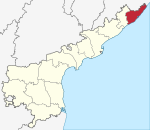
|
| VZ | Vizianagaram | Vizianagaram | Vizianagaram | 2 | 26 | 2,342,868 | 6,539 | 384 | 1016/1000 | 
|
| - | Manyam | Parvathipuram | Parvathipuram | 2 | 16 | - | - | - | - | |
| VS | Visakhapatnam | Visakhapatnam | Visakhapatnam | 2 | 10 | 4,288,113 | 11,161 | 340 | 1006/1000 | 
|
| - | Alluri Sitarama Raju | Paderu | Paderu | 2 | 22 | |||||
| - | Anakapalli | Anakapalli | Anakapalli | 2 | 25 | |||||
| EG | East Godavari | Rajahmundry | Rajahmundry | 2 | 20 | 5,151,549 | 10,807 | 477 | 1005/1000 | 
|
| - | Kakinada | Kakinada | Kakinada | 2 | 19 | |||||
| - | Konaseema | Amalapuram | Amalapuram | 2 | 24 | |||||
| WG | West Godavari | Bhimavaram | Bhimavaram | 2 | 19 | 3,934,782 | 7,742 | 490 | 1004/1000 | 
|
| - | Eluru | Eluru | Eluru | 3 | 27 | |||||
| KR | Krishna | Machilipatnam | Machilipatnam | 2 | 25 | 4,529,009 | 8,727 | 519 | 992/1000 | 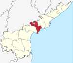
|
| - | NTR | Vijayawada | Vijayawada | 3 | 20 | |||||
| GU | Guntur | Guntur | Guntur | 2 | 18 | 4,889,230 | 11,391 | 429 | 1003/1000 | 
|
| - | Bapatla | Bapatla | Chirala | 2 | 25 | |||||
| - | Palnadu | Narasaraopeta | Narasaraopeta | 2 | 28 | |||||
| PR | Prakasam | Ongole | Ongole | 3 | 38 | 3,392,764 | 17,626 | 193 | 981/1000 | 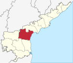
|
| NE | Nellore | Nellore | Nellore | 3 | 35 | 2,966,082 | 13,076 | 227 | 986/1000 | 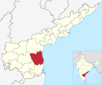
|
| KU | Kurnool | Kurnool | Kurnool | 2 | 28 | 4,046,601 | 17,658 | 229 | 988/1000 | 
|
| - | Nandyal | Nandyal | Nandyal | 3 | 27 | |||||
| AN | Anantapur | Anantapur | Anantapur | 3 | 34 | 4,083,315 | 19,130 | 213 | 977/1000 | 
|
| - | Sri Satyasai district | Puttaparthy | Hindupur | 3 | 29 | |||||
| CU | Kadapa | Kadapa | Kadapa | 3 | 34 | 2,884,524 | 15,359 | 188 | 985/1000 | 
|
| - | Annamaya | Rayachoti | Madanapalle | 3 | 32 | |||||
| CH | Chittoor | Chittoor | Chittoor | 2 | 33 | 4,170,468 | 15,152 | 275 | 985/1000 | 
|
| - | Sri Balaji | Tirupati | Tirupati | 3 | 35 |
Sources:
- Andhra Pradesh State Portal[4]
See also[]
External links[]
| Wikimedia Commons has media related to Districts of Andhra Pradesh. |
References[]
- ^ a b Raghavendra, V. (26 January 2022). "With creation of 13 new districts, AP now has 26 districts". The Hindu. ISSN 0971-751X. Archived from the original on 26 January 2022. Retrieved 26 January 2022.
- ^ correspondent, dc (26 January 2022). "Government at doorstep: Andhra Pradesh to have 26 new districts". Deccan Chronicle. Retrieved 26 January 2022.
- ^ "NIC Policy on format of e-mail Address" (PDF). www.mail.nic.in. 11 September 2008. Archived from the original (PDF) on 11 September 2008. Retrieved 15 February 2021.
- ^ "Population of AP districts(2011)". ap.gov.in. p. 14. Archived from the original (PDF) on 22 October 2020. Retrieved 13 March 2021.
| Topics | |||||
|---|---|---|---|---|---|
| Regions | |||||
| Districts |
| ||||
| Million-plus cities | |||||
| Cities (population over 1 lakh) |
| ||||
| Tourism |
| ||||
| History | |||||
| Related lists | |||||
| |||||
| States | ||
|---|---|---|
| Union territories | ||
| Related topics |
| |
- Andhra Pradesh-related lists
- Lists of districts in India
- Districts of Andhra Pradesh