Martin County, North Carolina
Martin County | |
|---|---|
U.S. county | |
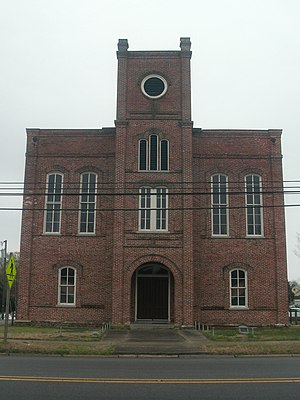 Historic Martin County Courthouse in Williamston. | |
 Location within the U.S. state of North Carolina | |
 North Carolina's location within the U.S. | |
| Coordinates: 35°50′N 77°06′W / 35.84°N 77.1°W | |
| Country | |
| State | |
| Founded | 1774 |
| Named for | Josiah Martin |
| Seat | Williamston |
| Largest town | Williamston |
| Area | |
| • Total | 462 sq mi (1,200 km2) |
| • Land | 461 sq mi (1,190 km2) |
| • Water | 0.3 sq mi (0.8 km2) 0.06%% |
| Population | |
| • Estimate (2018) | 22,671 |
| • Density | 53/sq mi (20/km2) |
| Time zone | UTC−5 (Eastern) |
| • Summer (DST) | UTC−4 (EDT) |
| Congressional district | 1st |
| Website | www |

Martin County is a county located in the U.S. state of North Carolina. As of the 2010 census, the population was 24,505.[1] Its county seat is Williamston.[2]
History[]
The county was formed in 1774 from the southeastern part of Halifax County and the western part of Tyrrell County. It was named for Josiah Martin, the last royal governor of North Carolina (1771–75).[3] Whereas Dobbs County and Tryon County, named for Martin's predecessors Arthur Dobbs and William Tryon, were abolished after American independence, Martin County was neither abolished nor renamed, a fact which has been attributed to the popularity of Alexander Martin, twice governor of the state (1782–84, 1789–92).
The Martin County Courthouse was listed on the National Register of Historic Places in 1979.[4]
Geography[]
According to the U.S. Census Bureau, the county has a total area of 462 square miles (1,200 km2), of which 461 square miles (1,190 km2) is land and 0.3 square miles (0.78 km2) (0.06%) is water.[5]
Adjacent counties[]
- Bertie County – northeast
- Washington County – east
- Beaufort County – southeast
- Pitt County – southwest
- Edgecombe County – west
- Halifax County – northwest
Major highways[]
Demographics[]
| Historical population | |||
|---|---|---|---|
| Census | Pop. | %± | |
| 1790 | 6,010 | — | |
| 1800 | 5,629 | −6.3% | |
| 1810 | 5,987 | 6.4% | |
| 1820 | 6,320 | 5.6% | |
| 1830 | 8,539 | 35.1% | |
| 1840 | 7,637 | −10.6% | |
| 1850 | 8,307 | 8.8% | |
| 1860 | 10,195 | 22.7% | |
| 1870 | 9,647 | −5.4% | |
| 1880 | 13,140 | 36.2% | |
| 1890 | 15,221 | 15.8% | |
| 1900 | 15,383 | 1.1% | |
| 1910 | 17,797 | 15.7% | |
| 1920 | 20,828 | 17.0% | |
| 1930 | 23,400 | 12.3% | |
| 1940 | 26,111 | 11.6% | |
| 1950 | 27,938 | 7.0% | |
| 1960 | 27,139 | −2.9% | |
| 1970 | 24,730 | −8.9% | |
| 1980 | 25,948 | 4.9% | |
| 1990 | 25,078 | −3.4% | |
| 2000 | 25,593 | 2.1% | |
| 2010 | 24,505 | −4.3% | |
| 2018 (est.) | 22,671 | [6] | −7.5% |
| U.S. Decennial Census[7] 1790–1960[8] 1900–1990[9] 1990–2000[10] 2010–2013[1] | |||
As of the census[11] of 2000, there were 25,593 people, 10,020 households, and 7,194 families residing in the county. The population density was 56 people per square mile (21/km2). There were 10,930 housing units at an average density of 24 per square mile (9/km2). The racial makeup of the county was 52.54% White, 45.37% Black or African American, 0.29% Native American, 0.24% Asian, 0.03% Pacific Islander, 0.90% from other races, and 0.63% from two or more races. 2.06% of the population were Hispanic or Latino of any race.
There were 10,020 households, out of which 31.60% had children under the age of 18 living with them, 50.30% were married couples living together, 17.60% had a female householder with no husband present, and 28.20% were non-families. 25.70% of all households were made up of individuals, and 11.90% had someone living alone who was 65 years of age or older. The average household size was 2.53 and the average family size was 3.02.
In the county, the population was spread out, with 25.50% under the age of 18, 7.50% from 18 to 24, 26.80% from 25 to 44, 25.00% from 45 to 64, and 15.20% who were 65 years of age or older. The median age was 39 years. For every 100 females there were 86.50 males. For every 100 females age 18 and over, there were 81.80 males.
The median income for a household in the county was $28,793, and the median income for a family was $35,428. Males had a median income of $29,818 versus $19,167 for females. The per capita income for the county was $15,102. About 16.30% of families and 20.20% of the population were below the poverty line, including 27.50% of those under age 18 and 25.70% of those age 65 or over.
Law and government[]
Martin County is a member of the Mid-East Commission regional council of governments.
Politics[]
Martin County is a historically Democratic county; in 2004, it voted Republican for only the fourth time ever, the first three having been in the Republican landslides of 1872, 1972, and 1984. Barack Obama won the county back for the Democratic Party in both 2008 and 2012, but in 2016, it narrowly backed Donald Trump. In 2020, it supported Trump again, voting for a losing Republican nominee for the first time ever, this time giving him an outright majority of the vote.[12][citation needed]
Education[]
The primary and secondary public school functions are performed by Martin County Schools, a district covering the entire county. Martin Community College is located in Williamston.
Notable people[]
- Annie Moore Cherry
- Wilber Hardee, founder of Hardee's
- William Drew Robeson I, minister of Witherspoon Street Presbyterian Church
Communities[]

Towns[]
- Bear Grass
- Everetts
- Hamilton
- Hassell
- Jamesville
- Oak City
- Robersonville
- Williamston
Townships[]
- Bear Grass
- Cross Roads
- Goose Nest
- Griffins
- Hamilton
- Jamesville
- Poplar Point
- Robersonville
- Williams
- Williamston
See also[]
Coordinates: 35°50′N 77°06′W / 35.84°N 77.10°W
References[]
- ^ Jump up to: a b "State & County QuickFacts". United States Census Bureau. Archived from the original on July 21, 2011. Retrieved October 27, 2013.
- ^ "Find a County". National Association of Counties. Retrieved 2011-06-07.
- ^ Gannett, Henry (1905). The Origin of Certain Place Names in the United States. U.S. Government Printing Office. p. 201.
- ^ "National Register Information System". National Register of Historic Places. National Park Service. July 9, 2010.
- ^ "2010 Census Gazetteer Files". United States Census Bureau. August 22, 2012. Archived from the original on January 12, 2015. Retrieved January 18, 2015.
- ^ "Population and Housing Unit Estimates". Retrieved July 22, 2019.
- ^ "U.S. Decennial Census". United States Census Bureau. Retrieved January 18, 2015.
- ^ "Historical Census Browser". University of Virginia Library. Retrieved January 18, 2015.
- ^ Forstall, Richard L., ed. (March 27, 1995). "Population of Counties by Decennial Census: 1900 to 1990". United States Census Bureau. Retrieved January 18, 2015.
- ^ "Census 2000 PHC-T-4. Ranking Tables for Counties: 1990 and 2000" (PDF). United States Census Bureau. April 2, 2001. Retrieved January 18, 2015.
- ^ "U.S. Census website". United States Census Bureau. Retrieved 2008-01-31.
- ^ "County winners, 1836-2016". Google Docs. Retrieved 2021-04-30.
- ^ Leip, David. "Dave Leip's Atlas of U.S. Presidential Elections". uselectionatlas.org. Retrieved 2018-03-16.
External links[]
- NCGenWeb Martin County – free genealogy resources for the county
| show Places adjacent to Martin County, North Carolina |
|---|
| show Municipalities and communities of Martin County, North Carolina, United States |
|---|


| show Authority control |
|---|
- North Carolina counties
- Martin County, North Carolina
- 1774 establishments in North Carolina
- Populated places established in 1774