Polk County, North Carolina
Polk County | |
|---|---|
U.S. county | |
 Polk County Courthouse | |
 Location within the U.S. state of North Carolina | |
 North Carolina's location within the U.S. | |
| Coordinates: 35°17′N 82°10′W / 35.28°N 82.17°W | |
| Country | |
| State | |
| Founded | 1855 |
| Named for | Colonel William Polk |
| Seat | Columbus |
| Largest town | Tryon |
| Area | |
| • Total | 239 sq mi (620 km2) |
| • Land | 238 sq mi (620 km2) |
| • Water | 0.7 sq mi (2 km2) 0.3%% |
| Population | |
| • Estimate (2018) | 20,611 |
| • Density | 86/sq mi (33/km2) |
| Time zone | UTC−5 (Eastern) |
| • Summer (DST) | UTC−4 (EDT) |
| Congressional district | 10th |
| Website | www |

Polk County is a county located in the U.S. state of North Carolina. As of the 2010 census, the population was 20,510.[1] Its county seat is Columbus.[2] The county was formed in 1855 from parts of Henderson County and Rutherford County. It was named for William Polk, a colonel in the American Revolutionary War. The Tryon International Equestrian Center, close to the community of Mill Spring was the location of the 2018 FEI World Equestrian Games.[3]
Geography[]
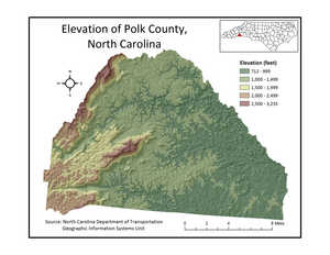
According to the U.S. Census Bureau, the county has a total area of 239 square miles (620 km2), of which 238 square miles (620 km2) is land and 0.7 square miles (1.8 km2) (0.3%) is water.[4] It is the fifth-smallest county in North Carolina by total area.
The county's largest body of water is Lake Adger, located about 5 miles (8.0 km) north of Columbus. Lake Adger is a reservoir formed by the damming of the Green River, which flows from west to east across the county. The northern extent of the river's watershed forms the northern border of the county.
The elevation in the county ranges from just under 800 feet (240 m) near the confluence of the Green River and Broad River to over 3,200 feet (980 m) on Tryon Peak and Wildcat Spur, the highest peak in the county. Polk County is divided into two physiographic regions; the Blue Ridge Mountains in the western third of the county and Piedmont for the eastern two-thirds. Since it is in a transition zone between the two regions, Polk County is often referred to as being in the foothills.
Adjacent counties[]
- Rutherford County - northeast
- Spartanburg County, South Carolina - south-southeast
- Greenville County, South Carolina - south-southwest
- Henderson County - west
Demographics[]
| Historical population | |||
|---|---|---|---|
| Census | Pop. | %± | |
| 1860 | 4,043 | — | |
| 1870 | 4,319 | 6.8% | |
| 1880 | 5,062 | 17.2% | |
| 1890 | 5,902 | 16.6% | |
| 1900 | 7,004 | 18.7% | |
| 1910 | 7,640 | 9.1% | |
| 1920 | 8,832 | 15.6% | |
| 1930 | 10,216 | 15.7% | |
| 1940 | 11,874 | 16.2% | |
| 1950 | 11,627 | −2.1% | |
| 1960 | 11,395 | −2.0% | |
| 1970 | 11,735 | 3.0% | |
| 1980 | 12,984 | 10.6% | |
| 1990 | 14,416 | 11.0% | |
| 2000 | 18,324 | 27.1% | |
| 2010 | 20,510 | 11.9% | |
| 2018 (est.) | 20,611 | [5] | 0.5% |
| U.S. Decennial Census[6] 1790-1960[7] 1900-1990[8] 1990-2000[9] 2010-2013[1] | |||
As of the census[10] of 2000, there were 18,324 people, 7,908 households, and 5,337 families residing in the county. The population density was 77 people per square mile (30/km2). There were 9,192 housing units at an average density of 39 per square mile (15/km2). The racial makeup of the county was 92.26% White, 5.89% Black or African American, 0.19% Native American, 0.24% Asian, 0.03% Pacific Islander, 0.63% from other races, and 0.76% from two or more races. 3.01% of the population were Hispanic or Latino of any race.
As of the census[10] of 2000 the largest self-reported ancestry groups were:[11]
- English - 17%
- Irish - 13%
- German - 13%
- Scotch-Irish - 7%
- African American- 5.89%
- Scottish - 4%
- Italian - 3%
There were 7,908 households, out of which 23.50% had children under the age of 18 living with them, 56.30% were married couples living together, 7.90% had a female householder with no husband present, and 32.50% were non-families. 28.90% of all households were made up of individuals, and 15.00% had someone living alone who was 65 years of age or older. The average household size was 2.28 and the average family size was 2.78.
In the county, the population was spread out, with 20.10% under the age of 18, 5.80% from 18 to 24, 24.20% from 25 to 44, 26.30% from 45 to 64, and 23.60% who were 65 years of age or older. The median age was 45 years. For every 100 females there were 90.20 males. For every 100 females age 18 and over, there were 87.10 males.
The median income for a household in the county was $36,259, and the median income for a family was $45,096. Males had a median income of $29,375 versus $23,070 for females. The per capita income for the county was $19,804. 10.10% of the population and 6.40% of families were below the poverty line. 11.70% of those under the age of 18 and 8.80% of those 65 and older were living below the poverty line.
Transportation[]
Major highways[]
The interchange for I-26 and the US 74 freeway is located in Columbus. Interstate 26 provides Polk County with easy access to Asheville and Spartanburg.
Polk County is also served by an additional non-freeway U.S. Highway: US 176. This was the primary highway linking Saluda and Tryon to Hendersonville and Spartanburg, S.C. prior to the delayed completion of I-26 in 1976. Two North Carolina routes, NC 108 and NC 9, traverse the county as well. NC 108 begins in Rutherfordton and travels west through Columbus and ends at US 176 in Tryon. Oriented north-to-south, NC 9 connects Black Mountain and Lake Lure to Spartanburg and points southeast via Polk County. NC 108 and NC 9 intersect at the unincorporated town of Mill Spring.
Rail[]
Polk County and Saluda are infamous among railroad enthusiasts for the Saluda Grade, the steepest standard-gauge mainline railway grade in the United States.[12] Norfolk Southern suspended freight traffic indefinitely along this route in December 2001. The track remains in place, but are cut near Flat Rock, North Carolina and Landrum, South Carolina.
Law and government[]
Polk County is a member of the Isothermal Planning and Development Commission regional council of governments. Sheila Whitmire is the current (as of 2012) Registrar of Deeds[13] and Patrick McCool serves as the current mayor of Columbus, the county seat.[14][citation needed]
Politics[]
2016[]
In the 2016 Republican Primary in Polk County, Donald Trump received 1,624 votes (or 46.2% of the total votes) followed by Ted Cruz who came in second with 1,135 votes (or 32.3% of the total votes). In the 2016 Democratic Primary, Bernie Sanders received 1,123 votes (48.7% of the total) whereas Hillary Clinton won 1,099 votes (47.7% of the total).[16] In the general election Donald Trump received 6,768 votes (or 61.9% of the total vote) whereas Hillary Clinton received 3,735 votes (34.2% of the vote) and Libertarian Candidate Gary Johnson received 272 votes (2.5% of total votes in the county).[17]
Communities[]
City[]
- Saluda
Towns[]
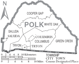
Townships[]
- Columbus
- Cooper's Gap
- Green Creek
- Saluda
- Tryon
- White Oak
See also[]
References[]
- ^ Jump up to: a b "State & County QuickFacts". United States Census Bureau. Archived from the original on January 22, 2016. Retrieved October 29, 2013.
- ^ "Find a County". National Association of Counties. Retrieved 2011-06-07.
- ^ "North Carolina to Host 2018 FEI World Equestrian Games". TheHorse.com. 3 November 2016. Retrieved 3 November 2016.
- ^ "2010 Census Gazetteer Files". United States Census Bureau. August 22, 2012. Archived from the original on January 12, 2015. Retrieved January 18, 2015.
- ^ "Population and Housing Unit Estimates". Retrieved July 24, 2019.
- ^ "U.S. Decennial Census". United States Census Bureau. Retrieved January 18, 2015.
- ^ "Historical Census Browser". University of Virginia Library. Retrieved January 18, 2015.
- ^ Forstall, Richard L., ed. (March 27, 1995). "Population of Counties by Decennial Census: 1900 to 1990". United States Census Bureau. Retrieved January 18, 2015.
- ^ "Census 2000 PHC-T-4. Ranking Tables for Counties: 1990 and 2000" (PDF). United States Census Bureau. April 2, 2001. Retrieved January 18, 2015.
- ^ Jump up to: a b "U.S. Census website". United States Census Bureau. Retrieved 2008-01-31.
- ^ "Polk County, NC - Polk County, North Carolina - Ancestry & family history - ePodunk". www.epodunk.com. Retrieved 2018-03-17.
- ^ Saluda Grade - North Carolina Highway Historical Marker Program Archived 2011-11-23 at the Wayback Machine
- ^ "ASSUMED BUSINESS NAME UPDATE". www.polknc.org. Retrieved 2021-02-28.
- ^ "Meet Our Mayor and Council". www.columbusnc.com. Retrieved 2021-02-28.
- ^ Leip, David. "Dave Leip's Atlas of U.S. Presidential Elections". uselectionatlas.org. Retrieved 2018-03-17.
- ^ "North Carolina Primary Election Results 2016". The New York Times. 2016-09-29. ISSN 0362-4331. Retrieved 2018-03-17.
- ^ "North Carolina Election Results 2016". The New York Times. 2017-08-01. ISSN 0362-4331. Retrieved 2018-03-17.
External links[]
- Polk County government official website
- NCGenWeb Polk County Archived 2016-10-19 at the Wayback Machine - free genealogy resources for the county
- BlueRidgeNow.com - The Times-News Online
- Polk County Sheriff's Department Webpage
- Western North Carolina Wine Trail
| show Places adjacent to Polk County, North Carolina |
|---|
| show Municipalities and communities of Polk County, North Carolina, United States |
|---|


Coordinates: 35°17′N 82°10′W / 35.28°N 82.17°W
| show Authority control |
|---|
- North Carolina counties
- Polk County, North Carolina
- Counties of Appalachia
- 1855 establishments in North Carolina
- Populated places established in 1855