Mata, Rio Grande do Sul
This article needs additional citations for verification. (January 2021) |
Mata | |
|---|---|
 | |
 Flag  Seal | |
 Location in Rio Grande do Sul, Brazil | |
 Mata Location in Brazil | |
| Coordinates: 29°33′57″S 54°27′36″W / 29.56583°S 54.46000°WCoordinates: 29°33′57″S 54°27′36″W / 29.56583°S 54.46000°W | |
| Country | Brazil |
| Region | South |
| State | Rio Grande do Sul |
| Government | |
| • Mayor | Sergio Roni Bruning |
| Area | |
| • Total | 312.120 km2 (120.510 sq mi) |
| Elevation | 127 m (417 ft) |
| Population (2020 [1]) | |
| • Total | 4,797 |
| • Density | 15/km2 (40/sq mi) |
| Time zone | UTC-3 (UTC-3) |
| • Summer (DST) | UTC-2 (UTC-2) |

Mata is a municipality in Rio Grande do Sul in Brazil.
Paleontology[]
The city of Mata has large deposits of petrified trees.
Museum of the city that have fossils:
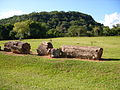
Petrified wood in the

São Roque community
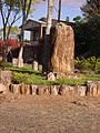
Petrified wood


References[]
External links[]
 Mata travel guide from Wikivoyage
| show |
|---|

| show Authority control |
|---|
 | This geographical article relating to Rio Grande do Sul is a stub. You can help Wikipedia by . |
Categories:
- Municipalities in Rio Grande do Sul
- Rio Grande do Sul geography stubs