Meymac
show This article may be expanded with text translated from the corresponding article in French. (January 2009) Click [show] for important translation instructions. |
Meymac | |
|---|---|
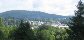 A general view of Meymac | |
 Coat of arms | |
show Location of Meymac | |
 Meymac | |
| Coordinates: 45°32′12″N 2°08′52″E / 45.5367°N 2.1478°ECoordinates: 45°32′12″N 2°08′52″E / 45.5367°N 2.1478°E | |
| Country | France |
| Region | Nouvelle-Aquitaine |
| Department | Corrèze |
| Arrondissement | Ussel |
| Canton | Plateau de Millevaches |
| Intercommunality | Haute-Corrèze Communauté |
| Government | |
| • Mayor (2020–2026) | Philippe Brugère |
| Area 1 | 87.15 km2 (33.65 sq mi) |
| Population (Jan. 2018)[1] | 2,322 |
| • Density | 27/km2 (69/sq mi) |
| Time zone | UTC+01:00 (CET) |
| • Summer (DST) | UTC+02:00 (CEST) |
| INSEE/Postal code | 19136 /19250 |
| Elevation | 593–973 m (1,946–3,192 ft) |
| 1 French Land Register data, which excludes lakes, ponds, glaciers > 1 km2 (0.386 sq mi or 247 acres) and river estuaries. | |


Meymac (French pronunciation: [memak]; Occitan: Maismac) is a commune in the department of Corrèze, in central France.
History[]
During the Hundred Years' War it was pillaged by Rodrigo de Villandrando.
Geography[]
The commune lies just south of the Millevaches Plateau and northwest of the Cantal mountains.
The Luzège has its source in the northern part of the commune; it flows south through the middle of the commune and crosses the town.
The Triouzoune forms most of the commune's eastern boundary.
Population[]
| Year | Pop. | ±% |
|---|---|---|
| 1962 | 2,411 | — |
| 1968 | 2,410 | −0.0% |
| 1975 | 2,434 | +1.0% |
| 1982 | 2,523 | +3.7% |
| 1990 | 2,796 | +10.8% |
| 1999 | 2,623 | −6.2% |
| 2008 | 2,625 | +0.1% |

Mont Bessou viewing tower at the highest point on the Plateau de Millevaches
Sights[]
See also[]
References[]
- ^ "Populations légales 2018". INSEE. 28 December 2020.
External links[]
| Wikimedia Commons has media related to Meymac. |
- (in French) Meymac and the Mont Bessou, its observation tower, photos of the panorama and the surroundings
| show Authority control |
|---|
This Corrèze geographical article is a stub. You can help Wikipedia by . |
Categories:
- Communes of Corrèze
- Limousin
- Corrèze geography stubs