Saint-Robert, Corrèze
show This article may be expanded with text translated from the corresponding article in French. (January 2009) Click [show] for important translation instructions. |
Saint-Robert | |
|---|---|
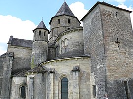 The church in Saint-Robert | |
 Coat of arms | |
show Location of Saint-Robert | |
 Saint-Robert | |
| Coordinates: 45°15′22″N 1°17′38″E / 45.2561°N 1.2938°ECoordinates: 45°15′22″N 1°17′38″E / 45.2561°N 1.2938°E | |
| Country | France |
| Region | Nouvelle-Aquitaine |
| Department | Corrèze |
| Arrondissement | Brive-la-Gaillarde |
| Canton | L'Yssandonnais |
| Intercommunality | CA Bassin de Brive |
| Government | |
| • Mayor (2020–2026) | Philippe Réné Hampikian |
| Area 1 | 6.08 km2 (2.35 sq mi) |
| Population (Jan. 2018)[1] | 297 |
| • Density | 49/km2 (130/sq mi) |
| Time zone | UTC+01:00 (CET) |
| • Summer (DST) | UTC+02:00 (CEST) |
| INSEE/Postal code | 19239 /19310 |
| Elevation | 158–354 m (518–1,161 ft) (avg. 325 m or 1,066 ft) |
| 1 French Land Register data, which excludes lakes, ponds, glaciers > 1 km2 (0.386 sq mi or 247 acres) and river estuaries. | |


Saint-Robert (Limousin: Sent Robèrt) is a commune in the Corrèze department in central France.
Population[]
| Year | Pop. | ±% |
|---|---|---|
| 1962 | 319 | — |
| 1968 | 343 | +7.5% |
| 1975 | 353 | +2.9% |
| 1982 | 371 | +5.1% |
| 1990 | 331 | −10.8% |
| 1999 | 334 | +0.9% |
| 2008 | 343 | +2.7% |
See also[]
References[]
- ^ "Populations légales 2018". INSEE. 28 December 2020.
| Wikimedia Commons has media related to Saint-Robert (Corrèze). |
| show Villages in the association Les Plus Beaux Villages de France |
|---|
| show Authority control |
|---|
This Corrèze geographical article is a stub. You can help Wikipedia by . |
Categories:
- Communes of Corrèze
- Plus Beaux Villages de France
- Corrèze geography stubs