Saint-Jean-de-Côle
Saint-Jean-de-Côle | |
|---|---|
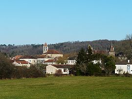 A general view of Saint-Jean-de-Côle | |
show Location of Saint-Jean-de-Côle | |
 Saint-Jean-de-Côle | |
| Coordinates: 45°25′19″N 0°50′21″E / 45.4219°N 0.8392°ECoordinates: 45°25′19″N 0°50′21″E / 45.4219°N 0.8392°E | |
| Country | France |
| Region | Nouvelle-Aquitaine |
| Department | Dordogne |
| Arrondissement | Nontron |
| Canton | Thiviers |
| Government | |
| • Mayor (2020–2026) | Francis Sedan[1] |
| Area 1 | 12.70 km2 (4.90 sq mi) |
| Population (Jan. 2018)[2] | 365 |
| • Density | 29/km2 (74/sq mi) |
| Time zone | UTC+01:00 (CET) |
| • Summer (DST) | UTC+02:00 (CEST) |
| INSEE/Postal code | 24425 /24800 |
| Elevation | 135–252 m (443–827 ft) (avg. 149 m or 489 ft) |
| 1 French Land Register data, which excludes lakes, ponds, glaciers > 1 km2 (0.386 sq mi or 247 acres) and river estuaries. | |


Saint-Jean-de-Côle (Limousin: Sent Joan de Còla) is a commune in the Dordogne department in Nouvelle-Aquitaine in southwestern France.
Geography[]
The Côle flows south-southwest through the middle of the commune and crosses the village.
Population[]
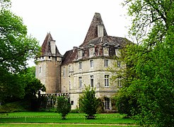
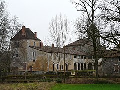
- Views of Saint-Jean-de-Côle


|
|
See also[]
References[]
- ^ "Répertoire national des élus: les maires". data.gouv.fr, Plateforme ouverte des données publiques françaises (in French). 2 December 2020.
- ^ "Populations légales 2018". INSEE. 28 December 2020.
| Wikimedia Commons has media related to Saint-Jean-de-Côle. |
| show Villages in the association Les Plus Beaux Villages de France |
|---|
| show Authority control |
|---|
This Dordogne geographical article is a stub. You can help Wikipedia by . |
Categories:
- Communes of Dordogne
- Plus Beaux Villages de France
- Dordogne geography stubs