Saint-Pierre-de-Côle
Saint-Pierre-de-Côle | |
|---|---|
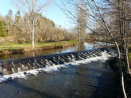 Côle River | |
show Location of Saint-Pierre-de-Côle | |
 Saint-Pierre-de-Côle | |
| Coordinates: 45°22′20″N 0°47′36″E / 45.3722°N 0.7933°ECoordinates: 45°22′20″N 0°47′36″E / 45.3722°N 0.7933°E | |
| Country | France |
| Region | Nouvelle-Aquitaine |
| Department | Dordogne |
| Arrondissement | Nontron |
| Canton | Thiviers |
| Government | |
| • Mayor (2008–2014) | Gérard Fleurat-Lessards |
| Area 1 | 19.85 km2 (7.66 sq mi) |
| Population (Jan. 2018)[1] | 425 |
| • Density | 21/km2 (55/sq mi) |
| Time zone | UTC+01:00 (CET) |
| • Summer (DST) | UTC+02:00 (CEST) |
| INSEE/Postal code | 24485 /24800 |
| Elevation | 119–237 m (390–778 ft) (avg. 130 m or 430 ft) |
| 1 French Land Register data, which excludes lakes, ponds, glaciers > 1 km2 (0.386 sq mi or 247 acres) and river estuaries. | |


Saint-Pierre-de-Côle (Limousin: Sent Peir de Còla) is a commune in the Dordogne department in Nouvelle-Aquitaine in southwestern France.
Geography[]
The river Côle flows southwestward through the middle of the commune, crosses the village and forms part of the commune's south-western border. The village straddles the D 78 road from Brantôme to Saint-Jean-de-Côle. At the centre of the village is the village square with an ancient Romanesque church which has been heavily restored and the cafe/restaurant 'La Marmite'. There is also a post office and a bakery in the village.
The village festival takes place on the first weekend in August, and there are fireworks on the river.
Population[]
| Year | Pop. | ±% |
|---|---|---|
| 1793 | 888 | — |
| 1800 | 1,016 | +14.4% |
| 1806 | 886 | −12.8% |
| 1821 | 985 | +11.2% |
| 1831 | 1,048 | +6.4% |
| 1836 | 1,076 | +2.7% |
| 1841 | 1,028 | −4.5% |
| 1846 | 932 | −9.3% |
| 1851 | 1,030 | +10.5% |
| 1856 | 985 | −4.4% |
| 1861 | 1,069 | +8.5% |
| 1866 | 1,148 | +7.4% |
| 1872 | 1,144 | −0.3% |
| 1876 | 1,155 | +1.0% |
| 1881 | 1,198 | +3.7% |
| 1886 | 1,125 | −6.1% |
| 1891 | 1,048 | −6.8% |
| 1896 | 995 | −5.1% |
| 1901 | 923 | −7.2% |
| 1906 | 942 | +2.1% |
| 1911 | 909 | −3.5% |
| 1921 | 798 | −12.2% |
| 1926 | 799 | +0.1% |
| 1931 | 698 | −12.6% |
| 1936 | 726 | +4.0% |
| 1946 | 716 | −1.4% |
| 1954 | 605 | −15.5% |
| 1962 | 558 | −7.8% |
| 1968 | 539 | −3.4% |
| 1975 | 507 | −5.9% |
| 1982 | 490 | −3.4% |
| 1990 | 464 | −5.3% |
| 1999 | 444 | −4.3% |
| 2008 | 453 | +2.0% |
See also[]
References[]
- ^ "Populations légales 2018". INSEE. 28 December 2020.
| Wikimedia Commons has media related to Saint-Pierre-de-Côle. |
| show Authority control |
|---|
This Dordogne geographical article is a stub. You can help Wikipedia by . |
Categories:
- Communes of Dordogne
- Dordogne geography stubs