La Feuillade
La Feuillade | |
|---|---|
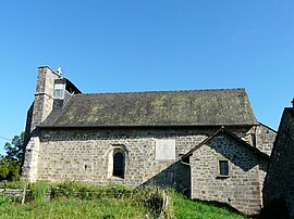 The church in La Feuillade | |
show Location of La Feuillade | |
 La Feuillade | |
| Coordinates: 45°06′53″N 1°24′13″E / 45.1147°N 1.4036°ECoordinates: 45°06′53″N 1°24′13″E / 45.1147°N 1.4036°E | |
| Country | France |
| Region | Nouvelle-Aquitaine |
| Department | Dordogne |
| Arrondissement | Sarlat-la-Canéda |
| Canton | Terrasson-Lavilledieu |
| Intercommunality | Terrassonnais en Périgord Noir Thenon Hautefort |
| Government | |
| • Mayor (2020–2026) | Daniel Baril |
| Area 1 | 3.97 km2 (1.53 sq mi) |
| Population (Jan. 2018)[1] | 751 |
| • Density | 190/km2 (490/sq mi) |
| Time zone | UTC+01:00 (CET) |
| • Summer (DST) | UTC+02:00 (CEST) |
| INSEE/Postal code | 24179 /24120 |
| Elevation | 89–322 m (292–1,056 ft) (avg. 160 m or 520 ft) |
| 1 French Land Register data, which excludes lakes, ponds, glaciers > 1 km2 (0.386 sq mi or 247 acres) and river estuaries. | |


La Feuillade (French pronunciation: [la fœjad]; Occitan: La Fuelhada) is a commune in the Dordogne department in Nouvelle-Aquitaine in southwestern France.
Population[]
| Year | Pop. | ±% p.a. |
|---|---|---|
| 1962 | 277 | — |
| 1968 | 328 | +2.86% |
| 1975 | 417 | +3.49% |
| 1982 | 519 | +3.18% |
| 1990 | 568 | +1.13% |
| 1999 | 710 | +2.51% |
| 2008 | 750 | +0.61% |
See also[]
References[]
- ^ "Populations légales 2018". INSEE. 28 December 2020.
| Wikimedia Commons has media related to La Feuillade. |
This Dordogne geographical article is a stub. You can help Wikipedia by . |
Categories:
- Communes of Dordogne
- Dordogne geography stubs