Montpeyroux, Dordogne
Montpeyroux | |
|---|---|
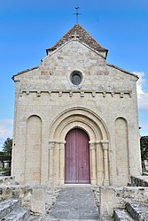 The church in Montpeyroux | |
 Coat of arms | |
show Location of Montpeyroux | |
 Montpeyroux | |
| Coordinates: 44°55′16″N 0°03′28″E / 44.9211°N 0.0578°ECoordinates: 44°55′16″N 0°03′28″E / 44.9211°N 0.0578°E | |
| Country | France |
| Region | Nouvelle-Aquitaine |
| Department | Dordogne |
| Arrondissement | Bergerac |
| Canton | Pays de Montaigne et Gurson |
| Government | |
| • Mayor (2020–2026) | Christophe Marceteau |
| Area 1 | 23.37 km2 (9.02 sq mi) |
| Population (Jan. 2018)[1] | 451 |
| • Density | 19/km2 (50/sq mi) |
| Time zone | UTC+01:00 (CET) |
| • Summer (DST) | UTC+02:00 (CEST) |
| INSEE/Postal code | 24292 /24610 |
| Elevation | 17–100 m (56–328 ft) (avg. 100 m or 330 ft) |
| 1 French Land Register data, which excludes lakes, ponds, glaciers > 1 km2 (0.386 sq mi or 247 acres) and river estuaries. | |


Montpeyroux (French pronunciation: [mɔ̃peʁu]; Occitan: Montpeirós) is a commune in the Dordogne department in Nouvelle-Aquitaine in southwestern France.
Population[]
| Year | Pop. | ±% |
|---|---|---|
| 1962 | 514 | — |
| 1968 | 452 | −12.1% |
| 1975 | 359 | −20.6% |
| 1982 | 318 | −11.4% |
| 1990 | 338 | +6.3% |
| 1999 | 360 | +6.5% |
| 2008 | 424 | +17.8% |
See also[]
References[]
- ^ "Populations légales 2018". INSEE. 28 December 2020.
| Wikimedia Commons has media related to Montpeyroux (Dordogne). |
This Dordogne geographical article is a stub. You can help Wikipedia by . |
Categories:
- Communes of Dordogne
- Dordogne geography stubs