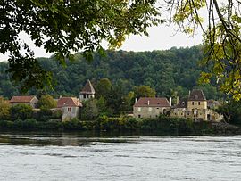
Pontours
Pontours | |
|---|---|
 Dordogne (river) | |
show Location of Pontours | |
 Pontours | |
| Coordinates: 44°50′13″N 0°45′46″E / 44.8369°N 0.7628°ECoordinates: 44°50′13″N 0°45′46″E / 44.8369°N 0.7628°E | |
| Country | France |
| Region | Nouvelle-Aquitaine |
| Department | Dordogne |
| Arrondissement | Bergerac |
| Canton | Lalinde |
| Government | |
| • Mayor (2008–2014) | Marie-Thérèse Armand |
| Area 1 | 6.69 km2 (2.58 sq mi) |
| Population (Jan. 2018)[1] | 190 |
| • Density | 28/km2 (74/sq mi) |
| Time zone | UTC+01:00 (CET) |
| • Summer (DST) | UTC+02:00 (CEST) |
| INSEE/Postal code | 24334 /24150 |
| Elevation | 36–175 m (118–574 ft) (avg. 44 m or 144 ft) |
| 1 French Land Register data, which excludes lakes, ponds, glaciers > 1 km2 (0.386 sq mi or 247 acres) and river estuaries. | |


Pontours is a commune in the Dordogne department in Nouvelle-Aquitaine in southwestern France.
Population[]
| Year | Pop. | ±% |
|---|---|---|
| 1962 | 160 | — |
| 1968 | 163 | +1.9% |
| 1975 | 153 | −6.1% |
| 1982 | 164 | +7.2% |
| 1990 | 187 | +14.0% |
| 1999 | 168 | −10.2% |
| 2008 | 201 | +19.6% |
See also[]
References[]
- ^ "Populations légales 2018". INSEE. 28 December 2020.
External links[]
| Wikimedia Commons has media related to Pontours. |
This Dordogne geographical article is a stub. You can help Wikipedia by . |
Categories:
- Communes of Dordogne
- Dordogne geography stubs