Journiac
Journiac | |
|---|---|
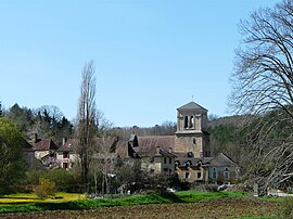 A general view of Journiac | |
 Coat of arms | |
show Location of Journiac | |
 Journiac | |
| Coordinates: 44°57′59″N 0°53′03″E / 44.9664°N 0.8842°ECoordinates: 44°57′59″N 0°53′03″E / 44.9664°N 0.8842°E | |
| Country | France |
| Region | Nouvelle-Aquitaine |
| Department | Dordogne |
| Arrondissement | Sarlat-la-Canéda |
| Canton | Vallée de l'Homme |
| Government | |
| • Mayor (2020–2026) | Michel Bouynet |
| Area 1 | 18.88 km2 (7.29 sq mi) |
| Population (Jan. 2018)[1] | 443 |
| • Density | 23/km2 (61/sq mi) |
| Time zone | UTC+01:00 (CET) |
| • Summer (DST) | UTC+02:00 (CEST) |
| INSEE/Postal code | 24217 /24260 |
| Elevation | 85–254 m (279–833 ft) (avg. 126 m or 413 ft) |
| 1 French Land Register data, which excludes lakes, ponds, glaciers > 1 km2 (0.386 sq mi or 247 acres) and river estuaries. | |


Journiac (French pronunciation: [ʒuʁnjak]; Occitan: Jornhac) is a commune in the Dordogne department in Nouvelle-Aquitaine in southwestern France.
Population[]
| Year | Pop. | ±% |
|---|---|---|
| 1962 | 338 | — |
| 1968 | 309 | −8.6% |
| 1975 | 276 | −10.7% |
| 1982 | 305 | +10.5% |
| 1990 | 345 | +13.1% |
| 1999 | 365 | +5.8% |
| 2008 | 408 | +11.8% |
See also[]
References[]
- ^ "Populations légales 2018". INSEE. 28 December 2020.
| Wikimedia Commons has media related to Journiac. |
This Dordogne geographical article is a stub. You can help Wikipedia by . |
Categories:
- Communes of Dordogne
- Dordogne geography stubs