Saint-Guilhem-le-Désert
Saint-Guilhem-le-Désert | |
|---|---|
 Gellone monastery | |
 Coat of arms | |
show Location of Saint-Guilhem-le-Désert | |
 Saint-Guilhem-le-Désert | |
| Coordinates: 43°44′05″N 3°33′02″E / 43.7347°N 3.5506°ECoordinates: 43°44′05″N 3°33′02″E / 43.7347°N 3.5506°E | |
| Country | France |
| Region | Occitanie |
| Department | Hérault |
| Arrondissement | Lodève |
| Canton | Gignac |
| Government | |
| • Mayor (2008–2014) | Philippe Machetel |
| Area 1 | 38.64 km2 (14.92 sq mi) |
| Population (Jan. 2018)[1] | 249 |
| • Density | 6.4/km2 (17/sq mi) |
| Time zone | UTC+01:00 (CET) |
| • Summer (DST) | UTC+02:00 (CEST) |
| INSEE/Postal code | 34261 /34150 |
| Elevation | 54–812 m (177–2,664 ft) (avg. 89 m or 292 ft) |
| 1 French Land Register data, which excludes lakes, ponds, glaciers > 1 km2 (0.386 sq mi or 247 acres) and river estuaries. | |


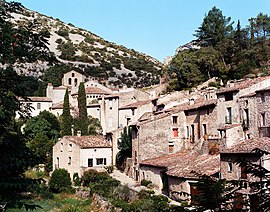
Saint-Guilhem-le-Désert (Occitan: Sant Guilhèm dau Desèrt) is a commune in the Hérault department in the Occitanie region in southern France. Situated in the narrow valley of the Gellone river where it meets the steep-sided gorge of the Hérault River, Saint-Guilhem-le-Désert is essentially a medieval village located on the Chemin de St-Jacques (Way of St. James) pilgrim route to Santiago de Compostella.
Geography[]
The area of the municipality of Saint-Guilhem is nearly 40km² in area. The town is serviced by two departmental roads D122 and D4, and the nearest towns are Ganges, near the source of the Hérault, about 35 km away, Montpellier also 35 km away, Gignac 15 km away, Saint-André-de-Sangonis 12 km away and Lodève (via A 75, Gignac and Aniane) 35 km distant.
The town, which has retained a medieval appearance, is located on the borders of the Massif Central, in the middle valley of the Hérault, north of the department of the same name. The territory of the town lies in an intramontane zone formed by the extension of the Séranne mountain and the Cellette mountain a few kilometres from the Garrigues of the plain of Languedoc.
Hydrography[]
It is watered by the Hérault and . The Hérault River, the Combe des Arboussets and the Poujols are the main rivers that water the town.
History[]
The village has maintained its historic state. Because of its isolation, in 806 Saint Guilhem established the monastery of Gellone here.
In 804, the count of Toulouse and Duke of Aquitaine Guilhèm in langue d'oc (saint Guillaume) founded at a time when the valley was virtually uninhabited, hence considered "desert". The abbey was originally called The Abbey of Gellone, until after Guillaume died in 812 when it was named The Abbey of Guillaume, and then the Abbey of Saint-Guilhem after his canonization in 1066.
The , nearby, was founded around 782 by a relative of Guillaume.
The abbey became a very important pilgrimage site in the middle ages due to a claim that a relic of a piece of the true cross was housed here. The town developed around the abbey.
In the Middle Ages, the abbey fell within the territory of the diocese of Lodeve.
During the French Revolution, the town temporarily bore the name of Verdus-le-Désert.[2]
Landmarks[]
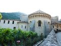
- The parish church is the former abbey church of the abbey of Gellone where we find the best preserved French organ of .
- The cloister of the abbey. A large part of this cloister was sold and dismantled during the French Revolution and exported to the United States, where some of it is in the New York Cloister Museum.
- The town is on the roads of Santiago de Compostela.
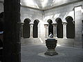
- The Abbey Museum was the dining room of the monks, is presented the collection of sculptures of the cloister, the sarcophagi of St. Guilhem and his sisters.
- The tower of the prisons and the castle of the Giant, elements of fortification and defence of the borough.
- The , "one of the most beautiful caves in France.[3]
Culture[]
In summer, the abbey of Saint-Guilhem-le-Désert and the chapel of the Penitents are the venues for concerts, especially those of the Rencontres Musicales of Saint-Guilhem-le-Désert, those of the Friends of Saint-Guilhem-le-Désert. Guilhem and the Camerata Mediterranea[citation needed].
Population[]
| Year | Pop. | ±% |
|---|---|---|
| 1962 | 197 | — |
| 1968 | 229 | +16.2% |
| 1975 | 274 | +19.7% |
| 1982 | 236 | −13.9% |
| 1990 | 190 | −19.5% |
| 1999 | 245 | +28.9% |
| 2008 | 256 | +4.5% |
Miscellaneous[]
Saint-Guilhem-le-Désert is one of the Plus Beaux Villages de France ("The most beautiful villages of France"), and the Abbey of Gellone, along with the nearby Pont du Diable were designated UNESCO World Heritages sites in 1999.[4]
A part of the cloister of the monastery was moved to The Cloisters museum in New York City.[5] A new sculpture museum, containing stone works from the abbey, was dedicated on June 26, 2009. In coordination with this event, a weekend of music and a colloquium was organized in large part by the Camerata Mediterranea.[citation needed]
Gallery[]


A sign marking the Way of Saint James in Saint Guilhem le Désert


La mairie de Saint-Guilhem-le-Désert

Secrétariat de la mairie

Rue du bourg de Saint-Guilhem-le-Désert

La tour des prisons
L'église abbatiale vue de l'aval

L'église abbatiale et le cloître

Le chevet de l'abbatiale de Saint-Guilhem

Orgue Jean-Pierre Cavaillé de l'abbaye de Gellone
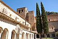
Cloître du monastère
Cloître reconstruit au musée The Cloisters aux États-Unis
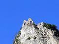
Les ruines du géant
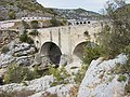
Pont du Diable (ou Pont de Saint Guilhem datant du Moyen Âge) enjambant l'Hérault

Nouveau pont sur l'Hérault (1932), à l'entrée des gorges de l' ; au fond, l'aqueduc.

Pont du canal « de Gignac » (env. 1890) et gorges de l'Hérault.


See also[]
References[]
- ^ "Populations légales 2018". INSEE. 28 December 2020.
- ^ Des villages de Cassini aux communes d'aujourd'hui: Commune data sheet Saint-Guilhem-le-Désert, EHESS. (in French)
- ^ Grotte de Clamouse.
- ^ Unesco: Routes of Santiago de Compostela in France. https://whc.unesco.org/en/list/868/multiple=1&unique_number=1019
- ^ Daniel Kletke, The cloister of St.-Guilhem-le-Désert at The Cloisters in New York City, Köster, Berlin, 1997.
External links[]
| Wikimedia Commons has media related to Saint-Guilhem-le-Désert. |
| show Villages in the association Les Plus Beaux Villages de France |
|---|
| show Authority control |
|---|
- Communes of Hérault
- Plus Beaux Villages de France
- World Heritage Sites in France
- Burial sites of the Carolingian dynasty