Le Triadou
Le Triadou | |
|---|---|
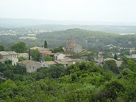 A general view of Le Triadou | |
 Coat of arms | |
show Location of Le Triadou | |
 Le Triadou | |
| Coordinates: 43°44���27″N 3°51′09″E / 43.7408°N 3.8525°ECoordinates: 43°44′27″N 3°51′09″E / 43.7408°N 3.8525°E | |
| Country | France |
| Region | Occitanie |
| Department | Hérault |
| Arrondissement | Lodève |
| Canton | Saint-Gély-du-Fesc |
| Intercommunality | Grand Pic Saint-Loup |
| Government | |
| • Mayor (2020–2026) | Pascal Vabre |
| Area 1 | 6.3 km2 (2.4 sq mi) |
| Population (Jan. 2018)[1] | 519 |
| • Density | 82/km2 (210/sq mi) |
| Time zone | UTC+01:00 (CET) |
| • Summer (DST) | UTC+02:00 (CEST) |
| INSEE/Postal code | 34314 /34270 |
| Elevation | 63–142 m (207–466 ft) (avg. 100 m or 330 ft) |
| 1 French Land Register data, which excludes lakes, ponds, glaciers > 1 km2 (0.386 sq mi or 247 acres) and river estuaries. | |


Le Triadou (French pronunciation: [lə tʁijadu]; Occitan: Lo Triador) is a commune in the Hérault department in the Occitanie region in southern France.
Population[]
| Year | Pop. | ±% |
|---|---|---|
| 1962 | 85 | — |
| 1968 | 93 | +9.4% |
| 1975 | 125 | +34.4% |
| 1982 | 143 | +14.4% |
| 1990 | 262 | +83.2% |
| 1999 | 328 | +25.2% |
| 2008 | 378 | +15.2% |
See also[]
References[]
- ^ "Populations légales 2018". INSEE. 28 December 2020.
| Wikimedia Commons has media related to Le Triadou. |
This Hérault geographical article is a stub. You can help Wikipedia by . |
Categories:
- Communes of Hérault
- Hérault geography stubs